OT: 2025 Above Normal Atlantic Basin Tropical Activity Forecasts from CSU/NOAA; Erin a Cat 5, but should stay well off the east coast

RU848789

Heisman
Jul 27, 2001
64,200
43,325
113
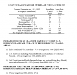
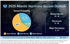
Well, this post on the coming tropical season in the Atlantic Basin is a little late, as I usually send these out in mid-June, but I’ve been busy having fun and goofing off instead. Anyway, CSU's and NOAA's 2025 Atlantic Basin Tropical Activity Predictions, which are both for “above average” levels of activity, are below, including some discussion. Will keep track of the seasonal count in this thread (3 weak TS's so far) and will start separate threads on any significant storms.

The forecasts from both Colorado State University (CSU, where the late Dr. Gray pioneered seasonal predictions, which are much more accurate than random guessing) and the National Oceanic and Atmospheric Administration (NOAA) have been for a busy season since early spring and now that the tropical season has officially started, the latest updates (5/22 from NOAA and 6/11 from CSU) from the two major sources continue to predict an active tropical season for the Atlantic Basin; see the links and graphics below. Also, note that the 3rd link, below, has a summary of predictions from about 20 different sources, with all of them predicting a moderately above normal season.

CSU's prediction is for 17 named storms (vs. the 30-year average of 14.4), 9 hurricanes (7.2 avg) and 4 major hurricanes (3.2 avg), while NOAA's forecast is very similar to CSU's, with predictions of 13-19 (mean of 16) named storms, of which 6-10 (mean of 8) are expected to become hurricanes, including 3-5 (mean of 4) major hurricanes; see the graphics and links below. These predictions from both CSU and NOAA are a bit above normal for tropical storms, hurricanes and major hurricanes, although not “way above” normal. It’s also worth noting that CSU includes a prediction of ACE, or the Accumulated Cyclone Energy Index for the all of the storms in the seaons, which is also decently above normal at 155 vs. 123 for a typical season.

However, note that whether a tropical season is considered above or below normal or just normal, what's most important, usually, is landfalling hurricanes, especially major ones (or ones with extraordinary rainfall), which is why last year's very active season wasn't particularly impactful, as only Idalia made US landfall as a major hurricane (and fortunately in the sparsely populated Big Bend area of Florida); similarly, in a below normal or normal year, all it takes is one monster, catastrophic landfalling storm, like Ian a couple of years ago, to make a season impactful. On the other hand, a season full of small, weak systems without major landfalls would not be considered that “bad” which is what we’ve had so far this season with 3 short-lived, weak tropical storms.

Also, as an FYI, last year’s forecasts by both CSU and NOAA were for an extremely active tropical season and we ended up with 18 named storms (14.4 avg), 11 hurricanes (7.2 avg) and 5 major hurricanes (3.2 avg), all of which are well above average and would mean the seasonal forecasts from most sources, like CSU and NOAA were reasonably accurate, despite the slow start to the season. CSU predicted 23 named storms, 11 hurricanes and 5 major hurricanes, so they were a bit low on named storms, but spot-on for hurricanes and major hurricanes, which most would argue are more important. And NOAA predicted 21 named storms, 10.5 hurricanes and 5.5 major hurricanes, which is also quite close to actual.

Both CSU and NOAA use much of the same combination of analog-based forecasts (looking back at key tropical indicators, like El Nino and tropical Atlantic sea surface temps (SSTs) for past seasons with similar indicators) and forward-looking dynamical/statistical global weather models. Both cite the ENSO (El Nino/Southern Oscillation indicator) state with its generally expected neutral conditions, i.e., there will likely be neither El Nino (warmer than normal equatorial Pacific Ccean temps) nor La Nina conditions (cooler than normal equatorial Pacific Ocean temps), which usually means more tropical activity, due to lowered wind shear over the Atlantic Basin, and they also cite the current and expected warmer-than-normal subtropical Atlantic SSTs (which also usually means more tropical activity and the potential for more powerful storms, as hurricanes use warmer waters as "fuel" for intensification) as keys to their forecasts.

We'll see soon, but keep in mind that the CSU group, in particular, has been far more accurate (near 70%) with their above normal, normal, below normal predictions than simple climatological guessing would be (1 in 3, on average, if guessing). Let's see how it all goes, but the predictions are a bit concerning, especially for coastal communities in the Gulf of Mexico, the US (and Canada) East Coast, and the Caribbean.

https://tropical.colostate.edu/forecasting.html
https://www.noaa.gov/.../noaa-predicts-above-normal-2025...
https://seasonalhurricanepredictions.org/.../seasonal...
1752033432466.png

1752033446395.png
 
Last edited:

RU848789

Heisman
Jul 27, 2001
64,200
43,325
113
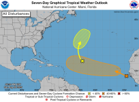
Well, looks like the tropics are heating up. We just had Tropical Storm Dexter form off the Carolinas a week ago, which headed harmlessly NE across the Atlantic, and now we have Invest 97L, a strong tropical wave just off the African coast, which could become Erin in the next 5-7 days (NHC says 60% chance of becoming a named storm in the next 7 days, as per the graphic below).

There are models showing this storm having the potential to impact the Caribbean in 8-10 days and maybe even the US east coast in 10-12 days, but there are also models that don't even show a storm or show a storm that stays out to sea. Modeling a storm that hasn't even formed yet is a highly uncertain endeavor with a huge number of possible outcomes that far out. So, no need to worry, yet, but this one needs to be watched closely.

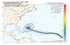
The 2nd graphic below is the output from the "superensemble" model, which includes the range of perturbed model outcomes in 8 day from multiple models, just to give a sense of the range of these outcomes; 10-12 days out would show even greater spread in outcomes. The link below is to the AmericanWx thread on this.

https://www.americanwx.com/bb/topic/62128-invest-97-now-at-1060/page/3/#comments

1754801751530.png

1754801773376.png
 
  • Like
Reactions: MADHAT1

RU848789

Heisman
Jul 27, 2001
64,200
43,325
113
Invest 97L, which is just west of the Cabo Verde Islands off the coast of Africa, is now forecast to become tropical storm Erin within the next day or so (and could already be one), as it has become better organized with more convection/storms. The big questions are its future track and intensity, although it's worth noting that even if it were to impact the US (possible, but not likely as of now, as most models and ensemble runs show the storm staying off the US east coast), that wouldn't be for 10-12 days.

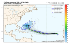
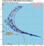
Currently, the global and hurricane models and their ensemble runs are showing that the storm is likely to become a hurricane by late this week (with warm ocean temps and light shear allowing strengthening) and is likely to move WNW to an area likely north of the Caribbean Islands by about 8 days from now, as per the superensembles (looks at perturbed runs of the major models to evaluate sensitivity to initial/boundary conditions) graphic below.

This is as far out as it's worth looking at models, given the fairly large spread in outcomes at even 8 days, as indicated by the blue ellipse, which shows the storm being anywhere from the Bahamas to east of Bermuda 7-8 days from now. So, while there is some chance of Erin impacting the US east coast, most of the data indicate the storm staying well offshore - but that being 10+ days out means a US landfall can't be ruled out yet. Links below are to the NHC site and Tomer Burg's (a very good met) excellent tropical site.

https://www.nhc.noaa.gov/
http://arctic.som.ou.edu/tburg/products/realtime/tropical/?storm=AL972025

1754923251796.png
 

DJ Spanky

Heisman
Jul 25, 2001
398,838
55,014
113
 

RU848789

Heisman
Jul 27, 2001
64,200
43,325
113
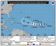
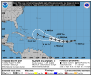
So, the NHC just named 97L Tropical Storm Erin with winds at 45 mph and forecast to reach 115 mph in 5 days at the end of its forecast (new graphic below, along with the track/intensity table. NHC won't really speculate beyond 5 days, so no new info on that.

FORECAST POSITIONS AND MAX WINDS

INIT 11/1500Z 17.4N 28.0W 40 KT 45 MPH
12H 12/0000Z 17.5N 31.2W 45 KT 50 MPH
24H 12/1200Z 17.4N 35.1W 50 KT 60 MPH
36H 13/0000Z 17.1N 38.7W 55 KT 65 MPH
48H 13/1200Z 17.1N 41.7W 60 KT 70 MPH
60H 14/0000Z 17.4N 45.0W 70 KT 80 MPH
72H 14/1200Z 18.0N 48.4W 80 KT 90 MPH
96H 15/1200Z 19.6N 54.0W 90 KT 105 MPH
120H 16/1200Z 21.5N 60.0W 100 KT 115 MPH

https://www.nhc.noaa.gov/graphics_at5.shtml?start#contents

1754924686981.png
 

RU848789

Heisman
Jul 27, 2001
64,200
43,325
113
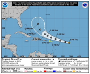
Erin moved a bit south of west since last night and might continue to do so today, so the model means and the NHC forecast have shifted a bit south since yesterday with the northern Leeward Islands and Puerto Rico (and likely Hispaniola) now just within the southern edge of the track cone at ~5 days, when Erin is also forecast to become a major (~115 mph winds) hurricane. Almost all of the models still show Erin moving NW then N after 5 days, meaning a track near or just west of Bermuda (and well of the US east coast) seems likely, but we're still 6-7 days from that turn, where model errors get quite large, so a landfall or close call for the US east coast from FL to New England (and the Canadian Maritimes) can't be ruled out yet, even if quite unlikely.

FORECAST POSITIONS AND MAX WINDS

INIT 12/1500Z 17.2N 36.3W 40 KT 45 MPH
12H 13/0000Z 16.8N 39.1W 40 KT 45 MPH
24H 13/1200Z 16.5N 42.3W 40 KT 45 MPH
36H 14/0000Z 16.6N 45.2W 45 KT 50 MPH
48H 14/1200Z 17.1N 48.3W 55 KT 65 MPH
60H 15/0000Z 17.8N 51.3W 65 KT 75 MPH
72H 15/1200Z 18.5N 54.4W 75 KT 85 MPH
96H 16/1200Z 19.8N 60.3W 90 KT 105 MPH
120H 17/1200Z 21.4N 65.0W 100 KT 115 MPH

1755011320788.png
 

DJ Spanky

Heisman
Jul 25, 2001
398,838
55,014
113
I'm worried about whether the Raritan will be flooding for the Friday night game against Iowa.
 
  • Sad
Reactions: RutgersNJ

bac2therac

Hall of Famer
Jul 30, 2001
236,299
165,618
113
i have to drive up to Burlington county on August 23rd at 3:30 PM, do you think the roads will be OK?
likely fine but we cannot rule flooding rain from a pop up severe cell or from any number of tropical systems that might form
 

RU848789

Heisman
Jul 27, 2001
64,200
43,325
113
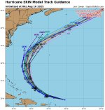
There is now more confidence that Tropical Storm Erin will become a major hurricane in a few days and after lashing the northern Caribbean islands over the next few days with rain/wind (but nowhere near a direct hit) Erin will very likely take a path between the US east coast and Bermuda in the next 7-8 days, staying well off the US east coast, as per every model (graphic below), but possibly coming close to Bermuda as a major hurricane. The chances of a US landfall aren't zero, but they're getting close to that.

After that the storm is forecast to head NE into the Atlantic, eventually becoming an extratropical storm that may impact Newfoundland and then shoots across the Atlantic towards Europe. However, it's a given that most of the east coast will experience large swells, heavy surf and dangerous riptides much of next week. So far, this storm has been predicted quite well by the NHC.

Also, there's now a 50% chance that a tropical entity in the SW Gulf of Mexico will develop into a tropical storm over the next day or so (would be named Fernand), which could then impact south Texas with heavy rains/flooding.

https://www.nhc.noaa.gov/

1755216809704.png

1755216826840.png
 

RUGuitarMan1

All-Conference
Apr 5, 2021
2,107
3,230
73
Friends of ours were scheduled for a cruise out of NYC to Bermuda on Monday. They’ve been contacted that a change in destination is very probable and may be heading to Canada. I mentioned to my wife a few weeks ago regarding their cruise, that the cutoff for me for a tropical cruise would be very early August. Mid August to mid October would be off limits.
 
  • Like
Reactions: RU848789

WillieTheSilent

Freshman
Jul 5, 2025
156
83
28
Hey look at me! NimberSan lol
C'mon, this could be something to watch. The length is a bit much.. I'd think this audience could use just the highlights and assume he knows what he's talking about. We know his sources by now... no need to quote them.
 

RU848789

Heisman
Jul 27, 2001
64,200
43,325
113
Friends of ours were scheduled for a cruise out of NYC to Bermuda on Monday. They’ve been contacted that a change in destination is very probable and may be heading to Canada. I mentioned to my wife a few weeks ago regarding their cruise, that the cutoff for me for a tropical cruise would be very early August. Mid August to mid October would be off limits.
smart man...
 
  • Like
Reactions: runrutgersrun

RU848789

Heisman
Jul 27, 2001
64,200
43,325
113
Holy rapid intensification Batman! Sharing the link to an incredible visible satellite loop (I hope the link works) of Hurricane Erin from around 8-9 am this morning as it was undergoing explosively rapid intensification from a 75 mph hurricane yesterday at 5 pm to a Cat 3 hurricane of 120 mph at 5 am this morning to a Cat 5 hurricane with 160 mph winds (at 915 mbar central pressure) at 11:20 am this morning. One of the fastest intensifications ever seen, especially before September. Erin has since weakened slightly to a strong Cat 4 storm with 150 mph winds (at 934 mbar), due to undergoing an eyewall replacement cycle, which was expected given how tiny the storm and its eye is (~10 miles across).

https://www.facebook.com/share/v/1BCoXa46hS/

Erin was able to strengthen so quickly due to the combination of anomalously high ocean temps in the Atlantic and very favorable conditions (low shear and minimal dry air). All I can say is that folks along the US east coast and in Bermuda look like they'll be incredibly lucky as Erin's track (see below), which has moved west a bit, is still forecast to have Erin pass about midway between the NC OBX and Bermuda (300+ miles from both points), meaning it's very likely that the only effects for the east coast (including Canada) and Bermuda will be very strong swells, heavy surf, dangerous riptides and beach erosion for much of the coming week (starting by Tuesday for the DE/NJ/NY area). A couple of links below...

https://www.nhc.noaa.gov/graphics_at5.shtml?start#contents
https://www.wunderground.com/.../2025-08-16-major...

user generated
 
  • Like
Reactions: RUGuitarMan1

T2Kplus20

Heisman
May 1, 2007
29,888
17,868
113
Holy rapid intensification Batman! Sharing the link to an incredible visible satellite loop (I hope the link works) of Hurricane Erin from around 8-9 am this morning as it was undergoing explosively rapid intensification from a 75 mph hurricane yesterday at 5 pm to a Cat 3 hurricane of 120 mph at 5 am this morning to a Cat 5 hurricane with 160 mph winds (at 915 mbar central pressure) at 11:20 am this morning. One of the fastest intensifications ever seen, especially before September. Erin has since weakened slightly to a strong Cat 4 storm with 150 mph winds (at 934 mbar), due to undergoing an eyewall replacement cycle, which was expected given how tiny the storm and its eye is (~10 miles across).

https://www.facebook.com/share/v/1BCoXa46hS/

Erin was able to strengthen so quickly due to the combination of anomalously high ocean temps in the Atlantic and very favorable conditions (low shear and minimal dry air). All I can say is that folks along the US east coast and in Bermuda look like they'll be incredibly lucky as Erin's track (see below), which has moved west a bit, is still forecast to have Erin pass about midway between the NC OBX and Bermuda (300+ miles from both points), meaning it's very likely that the only effects for the east coast (including Canada) and Bermuda will be very strong swells, heavy surf, dangerous riptides and beach erosion for much of the coming week (starting by Tuesday for the DE/NJ/NY area). A couple of links below...

https://www.nhc.noaa.gov/graphics_at5.shtml?start#contents
https://www.wunderground.com/.../2025-08-16-major...

user generated
Waste of a thread, just another fish storm.
 

RU848789

Heisman
Jul 27, 2001
64,200
43,325
113
Waste of a thread, just another fish storm.
You lost all credibility on hurricanes back when you kept downplaying Sandy, saying it was going to be a fish storm several days out when it was looking likely to hit the NE US and then saying its impacts would be minor, even when it was clear it was going to be catastrophic.
 
  • Like
Reactions: cioffineverrana43

RUinPinehurst

All-American
Aug 27, 2011
8,351
7,874
113
Waste of a thread, just another fish storm.
C'mon, man. Look at this as a pre-season storm thread, serious but an organized scrimmage to work out the kinks and get ready for the regular season that's just ahead.

All that said, here in western NC, we still have a long way to go to recover from Helene, which hit late last Sept. FEMA has come through in many ways, but we're still waiting on a private road repair program to assist. Our multi-home application was completed last November. Per FEMA, it's in process. The state of NC rolled out a similar program for private roads and bridges; we're accounted for there, as well, but no assistance yet in view.

The thought of a new storm season now upon us has many silently but very concerned.
 

T2Kplus20

Heisman
May 1, 2007
29,888
17,868
113
C'mon, man. Look at this as a pre-season storm thread, serious but an organized scrimmage to work out the kinks and get ready for the regular season that's just ahead.

All that said, here in western NC, we still have a long way to go to recover from Helene, which hit late last Sept. FEMA has come through in many ways, but we're still waiting on a private road repair program to assist. Our multi-home application was completed last November. Per FEMA, it's in process. The state of NC rolled out a similar program for private roads and bridges; we're accounted for there, as well, but no assistance yet in view.

The thought of a new storm season now upon us has many silently but very concerned.
Didn’t Helene come in from a completely different direction. This storm was fishy from the beginning. BTW, any updates on WOLF? :)
 

Scarlet4Shore

Senior
Feb 27, 2009
2,259
554
63
Looks like some fish are gonna be traumatized.
Yes, but the rip currents will be all along the shore for days. Let this serve as a PSA -- listen to the lifeguards, and don't go in the water when they are off duty! A 13 y/o girl drowned Friday night in Belmar after the lifeguards were gone. Lifeguards have been making saves all over the shore the past few weeks.
 
  • Like
Reactions: ldwnmas and Smols

DJ Spanky

Heisman
Jul 25, 2001
398,838
55,014
113
Yes, but the rip currents will be all along the shore for days. Let this serve as a PSA -- listen to the lifeguards, and don't go in the water when they are off duty! A 13 y/o girl drowned Friday night in Belmar after the lifeguards were gone. Lifeguards have been making saves all over the shore the past few weeks.

Well...........as a former lifeguard all I can say is that sometimes you just can't cure stupidity.
 

bac2therac

Hall of Famer
Jul 30, 2001
236,299
165,618
113
Water was fine and calm down the shore today. No rip tides. That will change starting Tuesday if not tomorrow
 
  • Like
Reactions: T2Kplus20

Scarlet4Shore

Senior
Feb 27, 2009
2,259
554
63
And where were their parents? That's the stupidity.
Per the Asbury Park Press:

Was the girl by herself?​

Belmar Beach Patrol Chief Harry Harsin said he understood that the girl, who was with family members, was reported to be visibly in distress just before she disappeared beneath the water.
 
  • Sad
Reactions: newell138

newell138

Heisman
Aug 1, 2001
35,030
44,044
112
Yes, but the rip currents will be all along the shore for days. Let this serve as a PSA -- listen to the lifeguards, and don't go in the water when they are off duty! A 13 y/o girl drowned Friday night in Belmar after the lifeguards were gone. Lifeguards have been making saves all over the shore the past few weeks.
The percent of drownings when lifeguards are on duty is basically zero. Its amazing how stupid some people are, especially those with no swimming skills who aren't familiar w/ the ocean.
 
  • Like
Reactions: Smols