“Now let’s talk snow. The January 15-16 signal (next Monday-Tuesday) has been very strongly advertised on long-range model guidance. The developing trough pattern supports a much colder precipitation type for whatever does happen.”
OT: Snow? - January 15-16?
- Thread starter Tango Two
- Start date
You are using an out of date browser. It may not display this or other websites correctly.
You should upgrade or use an alternative browser.
You should upgrade or use an alternative browser.

Models seem all over the place which is quite usual 5 days out so individual model outputs are useless at this point and anyone posting them are doing a disservice to forecasting
We know there is a potential for a snowstorm. There is also a potential for a whiff and a supression to the south
Prudently we wait until Friday nights cutter gets out of the way to see how the models play out
We know there is a potential for a snowstorm. There is also a potential for a whiff and a supression to the south
Prudently we wait until Friday nights cutter gets out of the way to see how the models play out
Thanks to TT and Bac for leading the way and keeping us informed! Should be interesting to track over the next few days.
“Now let’s talk snow. The January 15-16 signal (next Monday-Tuesday) has been very strongly advertised on long-range model guidance. The developing trough pattern supports a much colder precipitation type for whatever does happen.”
Was going to start a thread, but looks like Tango already has. No big deal, although it would be great, @Tango Two if you could update the title as appropriate. Anyway, here's what I had drafted...
Well, the coming cold has been mentioned numerous times and it's now a lock for this Saturday (pm after the front/rainstorm) through at least next week, with below normal temps (but not the brutal temps they're about to get in the Plains/Midwest); see the CPC graphic below for Days 6-10 (and this continues out to day 14 for the most part). More importantly, for most, is that we now have a pretty strong signal from all of the models for a some snow or mix (or a miss is still possible) next Tuesday, although the details are quite variable as one would expect 5 days out.
The Euro has consistently been showing a decent snowfall (3-6" or more range) for most of the area on Tuesday, 1/16, including the 95 corridor and the coast, for several model runs, while the other models have been all over the map (with most runs being complete misses or mostly rain), but their ensembles have been signaling a possible snowfall.
However, today's 12Z Euro shows a much flatter, suppressed whiff with all of the precip well to our SE, whereas the rest of today's 12Z model suite is showing something close to consensus, at least with regard to getting some snow for the whole area, with the GFS looking as snowy as the Euro has been for everyone (4-8" range) and the UK showing a decent snowstorm from 95 and NW, with less towards the coast due to mixing, while the CMC shows 95 being the battleground with good snows NW of 95 and nada just SE of 95 (like last Sat). But it's important to note that the 12Z Euro ensembles still show decent snow for everyone, possibly indicating that the 12Z Op run is a bit of an outlier. And the 18Z GFS is showing a significant snowstorm for everyone (6"+).
Also, the NWS has been pretty bullish on snow for Tuesday, as per the most recent guidance, below, and the map below showing an unusually high 30-50% probability of more than 2.5" of snow for our area on Tuesday, 5 days out. Still way too early for predictions, but this is the first time we've had a strong signal for cold and precip at the same time for the whole area in maybe 2 years (since 1/29/22). Biggest risk, IMO, is the strong confluence (high P) suppressing the storm to our south and missing or mostly missing us, as the Euro shows. Stay tuned as things will change, as they always do.
Area Forecast Discussion
National Weather Service Mount Holly NJ
429 PM EST Thu Jan 11 2024
High pressure will only briefly be in control as attention then
turns to a potential coastal low that looks to impact the area
sometime early to mid next week. Uncertainty remains with this
system, and model spread has actually increased with today`s 12z
guidance vs the 00z guidance. Although slight timing differences,
the GFS and Canadian are similar and closest to the coast with the
low. However, their ensembles are farther south and east. The latest
ECMWF is a big change from the previous run and shows a much weaker
low well offshore, leaving the area dry. This is the result of a
less amplified upper level trough and any energy out ahead of the
trough staying farther south off the southeast coast. Stuck
relatively close to NBM given the spread across guidance. PoPs are
capped at low end likely for the southern half of the area. Given
the cold air in place, taking a mean track between the ensembles and
deterministic guidance, excluding the ECMWF, precip type looks to be
snow across much of the area, with rain and/or snow across Long
Island. Did no want to jump on the ECMWF outlier yet, but this trend
will have to be monitored. At this time it is too early to talk
specific amounts. Behind this system, brief high pressure looks to
build in.
You think I would've been able to put all that together in a few minutes? No, it was all typed up over the past hour or so, while looking at a bunch of weather sites - I had said earlier today that I was going to start a thread...
Didn’t see it apologies
No need to apologize, thanks. You're not responsible for reading every post.Didn’t see it apologies
Think there is the possibility of a 3rd storm(1st one being this weekend) that rolls in late next week.
That one also having snowfall potential.
Bring it I say.
That one also having snowfall potential.
Bring it I say.
The 18Z Euro Ensemble Mean snowfall axis moved back NW a decent amount vs. 12Z, perhaps indicating that the suppressed 12Z Op run was a bit of an outlier. It's possible. For those not familiar, many pros put more stock in ensemble forecasts over the single "operational" run at this range, since the ensemble features 20-50 (depending on the model) variations on the op model run, using slightly perturbed initial conditions to gauge sensitivity of the model.
And when the Op model outcome is far different from the ensemble mean outcome, as it was for 12Z, where the Euro Op run showed a suppressed system, it's a bit of a red flag that the Op run might be a bit of an outlier, but not a guarantee that it is, which is why we need to see a few more model cycles to see if there are real trends or not.
In addition, we're still 5 days out and don't even know yet exactly where the big cutter rainstorm is going and its path may significantly impact the path/evolution of Tuesday's storm - plus the energy for Tuesday's storm still is out in the Pacific, so it's not being well sampled by the RAOB (radiosonde observation) network, meaning initial conditions are likely not robust, which can lead to odd outcomes at times. We'll know a ton more by Friday night/Saturday, but even then, it would be nice to see a bit more consensus tonight or tomorrow.
Summary of tonight's 0Z models below - probably not worth posting maps until we get within good range of the NAM/RGEM around Saturday night, which is also when we should have better initial conditions with the primary energy coming ashore in Oregon.
GFS is a significant to major snowstorm with 3-6" NW of 95 and 6-9" from 95 to the coast for most (less well N/W), as it's a classic Miller A (originating out of the Gulf of Mexico after meandering from Cali to Utah to south Texas starting Saturday night) which has a nearly perfect offshore track to the benchmark (40N/70W), which allows the cold air to be in place the whole event (Tues pm through Weds am) with temps in the mid/upper 20s the whole storm - this would likely mean snow/liquid ratios > 10:1.
CMC is a hugger along the coast/just inland, bringing an initial thump of 3-6" of snow for 95 and 6-9" NW of 95 (less at the coast) with a changeover to sleet, freezing rain and rain, especially along/SE of 95. It's faster than the GFS with all precip falling on Tuesday.
The UK is also a pretty big hit with 10"+ not far NW of 95, 6-10" for the 95 corridor and 3-6" towards the coast, due to some mixing with sleet and maybe rain; most precip falls on Tuesday.
Edit: Euro just came out and, again, is flat and suppressed with almost all of the precip off the coast - maybe just 20-40 miles closer to the NJ shore, but nada for everyone (and cold). Interestingly, the Euro was a bit of an outlier last night as the snowiest and now, tonight, it's a major outlier as the only non-snowy solution. Impossible to know what's going to happen, but I'd rather be in the camp with 3 of the 4 major global models than one, even if that one is the Euro - the best model by a bit, not by an overwhelming amount - and they measure that accuracy by assessing 5-day forecasts of pressure anomalies at 500 mbar, about 18K feet up (not via performance in east coast cyclones). If the Euro Op run is still at odds with its ensemble mean, as it was at 12Z, that'll be a continuing red flag that perhaps the Op is an outlier.
Anyway, so far this model suite looks pretty healthy for a winter storm, but we're still 4+ days out so quite a bit can change, especially up until Saturday night when the main energy comes into Cali.
P.S. both the Euro and CMC have a signal for another winter storm on 1/19...
Last edited:
Is this allowed?
“Now let’s talk snow. The January 15-16 signal (next Monday-Tuesday) has been very strongly advertised on long-range model guidance. The developing trough pattern supports a much colder precipitation type for whatever does happen.”

worth a checkShould I check the snow blower (Mercer County)?
Should I check the snow blower (Mercer County)?
I moved mine to front of garage so that means no snow. You can thank me later.
Numbers can help you wish it to happenI moved mine to front of garage so that means no snow. You can thank me later.
why dont you want some snowGive me some suppression Euro or whatever you call it.
a nice 2-3 inches every few days would be awesome
all I read/need. Truly a picture worth a thousand words. Thanks for including.
I think I got you beat. I just finished putting this little kit together. Definitely not snowing.I moved mine to front of garage so that means no snow. You can thank me later.

It's just a general pain in the ***.why dont you want some snow
a nice 2-3 inches every few days would be awesome

Continuing with the model mayhem today as the 6Z GFS was also a significant snowstorm for everyone, like last night's 0Z run, but the 12Z GFS came in much weaker and a bit SE with only about 1-3" of snow for most (a bit more offshore), while the 12Z CMC is colder than it was last night, so a general 6-10" for everyone with no mixing issues. And the UK shows 4-8" NW of 95, 1-4" for 95 corridor and very little at the coast, due to warmer temps/rain/mix. Euro up next.Summary of tonight's 0Z models below - probably not worth posting maps until we get within good range of the NAM/RGEM around Saturday night, which is also when we should have better initial conditions with the primary energy coming ashore in Oregon.
GFS is a significant to major snowstorm with 3-6" NW of 95 and 6-9" from 95 to the coast for most (less well N/W), as it's a classic Miller A (originating out of the Gulf of Mexico after meandering from Cali to Utah to south Texas starting Saturday night) which has a nearly perfect offshore track to the benchmark (40N/70W), which allows the cold air to be in place the whole event (Tues pm through Weds am) with temps in the mid/upper 20s the whole storm - this would likely mean snow/liquid ratios > 10:1.
CMC is a hugger along the coast/just inland, bringing an initial thump of 3-6" of snow for 95 and 6-9" NW of 95 (less at the coast) with a changeover to sleet, freezing rain and rain, especially along/SE of 95. It's faster than the GFS with all precip falling on Tuesday.
The UK is also a pretty big hit with 10"+ not far NW of 95, 6-10" for the 95 corridor and 3-6" towards the coast, due to some mixing with sleet and maybe rain; most precip falls on Tuesday.
Edit: Euro just came out and, again, is flat and suppressed with almost all of the precip off the coast - maybe just 20-40 miles closer to the NJ shore, but nada for everyone (and cold). Interestingly, the Euro was a bit of an outlier last night as the snowiest and now, tonight, it's a major outlier as the only non-snowy solution. Impossible to know what's going to happen, but I'd rather be in the camp with 3 of the 4 major global models than one, even if that one is the Euro - the best model by a bit, not by an overwhelming amount - and they measure that accuracy by assessing 5-day forecasts of pressure anomalies at 500 mbar, about 18K feet up (not via performance in east coast cyclones). If the Euro Op run is still at odds with its ensemble mean, as it was at 12Z, that'll be a continuing red flag that perhaps the Op is an outlier.
Anyway, so far this model suite looks pretty healthy for a winter storm, but we're still 4+ days out so quite a bit can change, especially up until Saturday night when the main energy comes into Cali.
P.S. both the Euro and CMC have a signal for another winter storm on 1/19...
I expect to see continued signficant fluctuations until maybe Sat night, when the main energy for the storm comes ashore in Oregon, plus we'll be only 48 hours out at that point, which greatly decreases the error bars for the models. Until then, we do at least have a potential winter storm on the table, but too much model variabiliity to have high confidence in snow/precip amounts. So we track...
Edti: the 12Z Euro just came out and it shifted its precip field NW about 150 miles, bringing 1-2" amounts to much of our area, but the 3-6" amounts are still over 100 miles SE and the 10"+ amounts are 150 miles SE. Looks quite similar to the GFS, but we at least now have every model showing at least some snow, with significant snowfall still on the table for everyone.
Last edited:
Needs more lights. ; )I think I got you beat. I just finished putting this little kit together. Definitely not snowing.
a nice 2-3 inches every few days would be awesome
It's just a general pain in the ***.
That’s NOT what she said


I love it when a plan comes together.
yeah my son was laughing at me too. Got the whole system off an old beat up mower from my father's estate couple years ago. Everything was brand new and I felt obligated lol.Needs more lights. ; )
But hey now. I can cut my grass at midnight now. :WooHoo:
Ukie is a 2-4 inch type storm for central jersey a bit more in nw jersey and basically inch or less toward the coast and south jersey
Dan Zarrow - With fresh cold air in place, we have to watch a potential storm system around Tuesday-Wednesday of next week. Statewide accumulating snow is a possible scenario. Still far from a slam dunk though — it could swing completely out to sea. (If there's something there, we'll start talking seriously about this one on Sunday.)
Because the usage I'm using is mayhem representing disorder and chaos and if you had experience with numerical model prediction of deterministic, but non-linear and chaotic systems like the weather, you'd know why we're seeing such varied outcomes given similar models and similar initial conditions. I've done very similar modeling for chemical reactors (similar to the weather, just on a much smaller scale, which decreases complexity vs. global weather, but with changing materials over time, which adds complexity) and it's amazing how much small starting point changes (and model physics) can influence eventual outcomes.it really isnt model mayhem so not sure why you catagorize it that way.
Snow blower is prepped and good to go. Gotta love an Ariens, always starts right up.
Thank you for your service.I moved mine to front of garage so that means no snow. You can thank me later.
Dan Zarrow - With fresh cold air in place, we have to watch a potential storm system around Tuesday-Wednesday of next week. Statewide accumulating snow is a possible scenario. Still far from a slam dunk though — it could swing completely out to sea. (If there's something there, we'll start talking seriously about this one on Sunday.)
Wait, there other sources of weather besides the RU FB board??!!
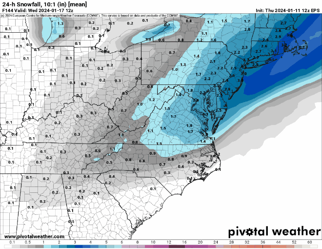
NWS still fairly bullish on this system, fwiw, as 30-50% on getting ~2.5" of snow 4 days out is pretty bullish...Continuing with the model mayhem today as the 6Z GFS was also a significant snowstorm for everyone, like last night's 0Z run, but the 12Z GFS came in much weaker and a bit SE with only about 1-3" of snow for most (a bit more offshore), while the 12Z CMC is colder than it was last night, so a general 6-10" for everyone with no mixing issues. And the UK shows 4-8" NW of 95, 1-4" for 95 corridor and very little at the coast, due to warmer temps/rain/mix. Euro up next.
I expect to see continued signficant fluctuations until maybe Sat night, when the main energy for the storm comes ashore in Oregon, plus we'll be only 48 hours out at that point, which greatly decreases the error bars for the models. Until then, we do at least have a potential winter storm on the table, but too much model variabiliity to have high confidence in snow/precip amounts. So we track...
Edti: the 12Z Euro just came out and it shifted its precip field NW about 150 miles, bringing 1-2" amounts to much of our area, but the 3-6" amounts are still over 100 miles SE and the 10"+ amounts are 150 miles SE. Looks quite similar to the GFS, but we at least now have every model showing at least some snow, with significant snowfall still on the table for everyone.

These images are so 2D. You need to find some interactive 3D stuff that illustrates the depth of the forecast snowfall across a particular geographic region. Where we can move around to the locations we want to check out, and drill down and see what it's going to look like at various points in the forecast storm.NWS still fairly bullish on this system, fwiw, as 30-50% on getting ~2.5" of snow 4 days out is pretty bullish...
What with AI assisted image production these days, it shouldn't be hard. And this way, we can do cool stuff like check out @DJ Spanky's backyard to see if the alligator is going to be fully covered by the snowfall and, if so, at what time of day during the storm.
A combination of Google earth imaging and 3D rendered snowfall over the satellite images, is what I'm talking about here.
So yeah. Put that on your list along with figuring out how to actually control the weather. Thanks, man.
Calling for dud here in South Jersey. My weatherunderground app is already backing off their predictions from yesterday.
What with AI assisted image production these days, it shouldn't be hard. And this way, we can do cool stuff like check out @DJ Spanky's backyard to see if the alligator is going to be fully covered by the snowfall and, if so, at what time of day during the storm.
As long as that alligator doesn't start humping my rain gauge, we're good. Of course, after the rain tonight and tomorrow, the gauge will come in so it doesn't split from the water freezing.
Calling for dud here in South Jersey. My weatherunderground app is already backing off their predictions from yesterday.
weather.com went from 3-5 inches to 1-3 inches within the last hour or so FWIW
That’s what my wife says.why dont you want some snow
a nice 2-3 inches every few days would be awesome