Weather buffs, give us an update on what
- Thread starter redfish66
- Start date
You are using an out of date browser. It may not display this or other websites correctly.
You should upgrade or use an alternative browser.
You should upgrade or use an alternative browser.
There have been some tornado warnings early today in Holmes County but I havent heard anything from there because it's still raining its *** off there.And as I write this another tornado warning issued for Holmes county.
Southernand East Central MS, along with most of ALis where we should keep our eye on for most of the rest of the day. Theseare going to be the best areas for isolated supercells with tornadic potential. Vicksburg and southern Warren Countyshould also watch out for that storm about to cross the river. This line going across the center of the state right now bears watching still. High winds and hail, along with a chance for tornadoes still possible with this line.
Southernand East Central MS, along with most of ALis where we should keep our eye on for most of the rest of the day. Theseare going to be the best areas for isolated supercells with tornadic potential. Vicksburg and southern Warren Countyshould also watch out for that storm about to cross the river. This line going across the center of the state right now bears watching still. High winds and hail, along with a chance for tornadoes still possible with this line.
Storm with a very real chance of producing a tornado. Those near Shubuta should be looking out for this. Also very large hail. They just warned on it as I was typing this.
Just issued a tornado warning on this storm. Jackson is right in the line of fire for this one. This one is a pretty big storm with a good chance of producing a tornado.
This one has the potential to head for Starkville as well. This storm has been alive for a while and is still moving good with some pretty decent hail.
This is a very strong storm and is very ugly on radar. There could be a lot of damage from this one.
All on campus should get inside and take cover. Also some damage reports coming in from Hinds County. Semis overturned, numerous houses destroyed, and gas leaks. This is very bad.
It is raining cats and dogs in Starkville. Sirens just went off but it has lightened up slightly since. Still looking bad for the time being
<div style="margin-left: 40px;">
</div>
<div style="margin-left: 40px;">
</div>
This storm has a couplet of rotation on it. This one could head right for campus. Folks in Choctaw and Oktibbeha need to watch closely.
Everyone be careful. Tornado Vortex Signature spotted on radar, so there is rotation with a possible tornado headed that way. It's just north of Sturgis now, so Starkville is right in the path.

Probably a tornado on the groundwith this one right now. Gatesville is in line for this to go right over it. There is going to be some impressive hail with this too. This is a sick storm.
ETA: Radar indicated possible baseball sized or larger hail.That could set some records I would think if someone canactually find a piece that large.
ETA: Radar indicated possible baseball sized or larger hail.That could set some records I would think if someone canactually find a piece that large.
<span> <embed src="http://www.youtube.com/v/jrkzBpeybkc?f=videos&app=youtube_gdata" type="application/x-shockwave-flash" wmode="transparent" width="425" height="355" allowScriptAccess="never" ></embed> </span>
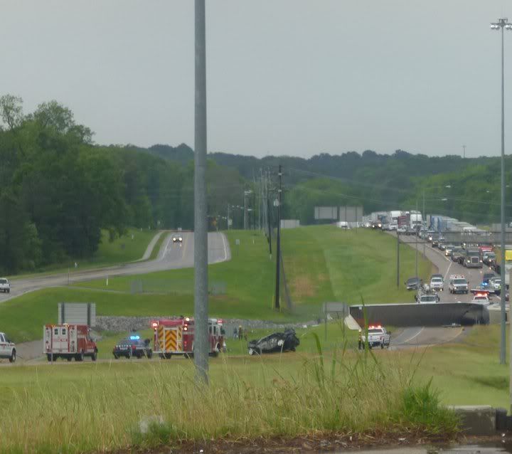
keep your eyes looking right under the bridge, you can see a car fly across both lanes of the interstate. This car came from the Bank Plus parking lot. I believe it's the black car you see in the photo below. Incredible.
I didn't see that the first couple of times I watched it. I only saw a car (same car?) get picked up a couple of seconds earlier, to the right of the bridge in the video.<div>
</div><div>You say the car came from the bank parking lot. Was anyone in the car or was it just parked in the lot?</div>
</div><div>You say the car came from the bank parking lot. Was anyone in the car or was it just parked in the lot?</div>