great- supposed to rain Friday
- Thread starter Coach34
- Start date
You are using an out of date browser. It may not display this or other websites correctly.
You should upgrade or use an alternative browser.
You should upgrade or use an alternative browser.
Might be a good thing, UF's Friday starter hasn't given up an earned run in his last 30 innings, and has only given up 3 earned runs in his 7 starts this season.
</a>
<table align="center" border="0" cellpadding="0" cellspacing="0" width="670"><tbody><tr valign="top"><td rowspan="2"><a href="http://www.noaa.gov/"> </td><td height="20">
 </td><td rowspan="2" align="right">
 </td></tr><tr align="center"><td class="white1" background="/images/wtf/forecast_blank.jpg" height="57">3 Miles E Mississippi State MS
 </td></tr></tbody></table><table align="center" background="/images/wtf/navbkgrnd.gif" border="0" cellpadding="0" cellspacing="0" width="670"><tbody><tr><td>
 </td><td class="searchinput" align="left"><span class="yellow">Enter Your "City, ST" or zip code </span><span class="searchinput"></span> </td><td align="right">
 </td></tr></tbody></table><table align="center" border="0" width="670"><tbody><tr><td><table align="center" border="0" cellpadding="0" cellspacing="0" width="100%"><tbody><tr><td align="left" valign="center">NWS Jackson, MS
Point Forecast: 3 Miles E Mississippi State MS
33.46°N 88.74°W</td><td align="right" valign="bottom">Mobile Weather Information | En Español
Last Update: 10:41 am CDT Apr 4, 2011
Forecast Valid: 12pm CDT Apr 4, 2011-6pm CDT Apr 10, 2011</td></tr></tbody></table><table align="center" border="0" cellpadding="0" cellspacing="0" width="100%"><tbody><tr><td align="left">
</td><td align="right">
</td></tr><tr><td colspan="2" align="left">

</td></tr></tbody></table></td></tr><tr><td><table align="center" border="0" cellpadding="0" cellspacing="0" width="100%"><tbody><tr align="center" valign="top"><td width="11%">This
Afternoon

Severe
Tstms
Hi <font color="#ff0000">77 °F</font>
 </td><td width="11%">Tonight

Chance
Tstms
Lo <font color="#0033cc">40 °F</font></td><td width="11%">Tuesday

Sunny
Hi <font color="#ff0000">64 °F</font></td><td width="11%">Tuesday
Night

Clear
Lo <font color="#0033cc">39 °F</font></td><td width="11%">Wednesday
Sunny
Hi <font color="#ff0000">75 °F</font></td><td width="11%">Wednesday
Night

Mostly
Clear
Lo <font color="#0033cc">52 °F</font></td><td width="11%">Thursday

Partly
Sunny
Hi <font color="#ff0000">78 °F</font></td><td width="11%">Thursday
Night

Partly
Cloudy
Lo <font color="#0033cc">63 °F</font></td><td width="11%">Friday
Mostly
Cloudy
Hi <font color="#ff0000">84 °F</font></td></tr></tbody></table><table align="center" border="0" cellpadding="0" cellspacing="0" width="100%"><tbody><tr valign="top"><td align="left" valign="top" width="50%">

<a name="contents"></a>
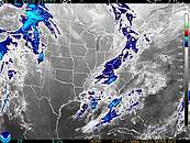
Hazardous weather condition(s):
<div align="center">
<span class="warn">Tornado Watch</span>
<span class="warn">Wind Advisory</span>
<span class="warn">Hazardous Weather Outlook</span>
<span class="warn">Short Term Forecast</span>
</div>
This Afternoon: Showers and thunderstorms, mainly after 1pm. Some
storms could be severe, with damaging winds. Temperature falling to
around 72 by 5pm. Southwest wind between 10 and 20 mph, with gusts as
high as 30 mph. Chance of precipitation is 90%. New rainfall amounts
between 1 and 2 inches possible.
Tonight: A 50 percent
chance of showers and thunderstorms before 10pm. Cloudy during the
early evening, then gradual clearing, with a low around 40. Northwest
wind 15 to 20 mph decreasing to between 5 and 10 mph. Winds could gust
as high as 30 mph. New rainfall amounts between a quarter and half of an
inch possible.
Tuesday: Sunny, with a high near 64. North northwest wind between 5 and 10 mph.
Tuesday Night: Clear, with a low around 39. Calm wind becoming south southeast around 5 mph.
Wednesday: Sunny, with a high near 75. South wind between 5 and 15 mph, with gusts as high as 20 mph.
Wednesday Night: Mostly clear, with a low around 52. South wind between 5 and 10 mph.
Thursday: Partly
sunny, with a high near 78. South wind 5 to 10 mph increasing to
between 15 and 20 mph. Winds could gust as high as 25 mph.
Thursday Night: Partly cloudy, with a low around 63. South wind between 10 and 15 mph.
Friday: Mostly cloudy, with a high near 84. South wind around 10 mph.
Friday Night: Mostly cloudy, with a low around 64.
Saturday: Partly sunny, with a high near 87.
Saturday Night: Partly cloudy, with a low around 65.
Sunday: A 30 percent chance of showers. Mostly cloudy, with a high near 84.
</td><td align="center" valign="top" width="50%">
 <map name="ccbanner"><area shape="rect" coords="268,0,325,19" target="_blank" href="http://forecast.weather.gov/MapClick.php?lat=33.45206821659518&lon=-88.73451232910156&site=jan&smap=1&unit=0&lg=en&FcstType=text&mp=0" alt="Move point forecast map up, and current conditions, radar, and satellite down." title="Move point forecast map up, and current conditions, radar, and satellite down."></map><table border="0" cellspacing="0" width="100%"><tbody><tr align="center"><td><p align="right">view Yesterday's Weather</p><span class="blue1">George M Bryan Airport</span>
Lat: 33.43 Lon: -88.85 Elev: 333
<font color="#ff0000">
Not a Current Observation
</font></td></tr><tr><td colspan="2"><table border="0" cellpadding="0" cellspacing="0"><tbody><tr><td class="big" align="center" width="120">NULL
NULL</td><td rowspan="2" width="200"><table border="0" cellpadding="2" cellspacing="0" width="100%"><tbody><tr bgcolor="#b0c4de"><td>Humidity:</td><td align="right">NULL</td></tr><tr bgcolor="#ffefd5"><td>Wind Speed:</td><td align="right">NULL</td></tr><tr bgcolor="#b0c4de"><td>Barometer:</td><td align="right" nowrap="nowrap">NULL</td></tr><tr bgcolor="#ffefd5"><td>Dewpoint:</td><td align="right">
</td></tr><tr bgcolor="#b0c4de"><td>Visibility:</td><td align="right">NULL</td></tr><tr><td nowrap="nowrap">More Local Wx:</td><td align="right" nowrap="nowrap">3 Day History:</td></tr></tbody></table></td></tr>
</tbody></table></td></tr><tr valign="top"><td align="center" valign="top" width="50%">


</td></tr></tbody></table>
 <map name="dpbanner"><area shape="rect" coords="268,0,325,19" target="_blank" href="http://forecast.weather.gov/MapClick.php?lat=33.45206821659518&lon=-88.73451232910156&site=jan&smap=1&unit=0&lg=en&FcstType=text&mp=0" alt="Move point forecast map up, and current conditions, radar, and satellite down." title="Move point forecast map up, and current conditions, radar, and satellite down."></map><table class="noprint" border="0" width="100%"><tbody><tr><td align="center">Click Map for ForecastDisclaimer</td></tr><tr><td align="center" valign="top"><div style="width: 320px; text-align: left;"><div id="gmap" style="width: 320px; height: 250px; position: relative; background-color: rgb(229, 227, 223);"><div><div><div><div>
 </div></div><div><div>
 </div></div><div>
 </div></div><div class="gmnoprint">
 </div><div class="gmnoprint">
 </div></div><div class="gmnoprint">
 </div><div dir="ltr"><span>Map data ©2011 Google - </span>Terms of Use</div><div class="gmnoprint"><div title="Show street map"><div style="font-size: 12px; border-width: 1px; border-style: solid; border-color: white rgb(176, 176, 176) rgb(176, 176, 176) white;">Map</div></div><div title="Show satellite imagery"><div style="font-size: 12px; border-width: 1px; border-style: solid; border-color: white rgb(176, 176, 176) rgb(176, 176, 176) white;">Satellite</div><div title="Show imagery with street names"><div style="font-size: 11px; padding-left: 2px; padding-right: 2px;">Show labels</div></div></div><div title="Show street map with terrain"><div style="font-size: 12px; border-width: 1px; border-style: solid; border-color: rgb(52, 86, 132) rgb(108, 157, 223) rgb(108, 157, 223) rgb(52, 86, 132); font-weight: bold;">Terrain</div></div></div><div class="gmnoprint">
 </div></div></div><div>
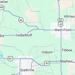
 </div>Lat/Lon: 33.46°N 88.74°W Elevation:249 ft


 </td></tr></tbody></table></td></tr></tbody></table></td></tr></tbody></table>
<table align="center" border="0" cellpadding="0" cellspacing="0" width="670"><tbody><tr valign="top"><td rowspan="2"><a href="http://www.noaa.gov/">
</td><td height="20">
</td></tr><tr align="center"><td class="white1" background="/images/wtf/forecast_blank.jpg" height="57">3 Miles E Mississippi State MS
</td></tr></tbody></table><table align="center" background="/images/wtf/navbkgrnd.gif" border="0" cellpadding="0" cellspacing="0" width="670"><tbody><tr><td>
</td></tr></tbody></table><table align="center" border="0" width="670"><tbody><tr><td><table align="center" border="0" cellpadding="0" cellspacing="0" width="100%"><tbody><tr><td align="left" valign="center">NWS Jackson, MSPoint Forecast: 3 Miles E Mississippi State MS
33.46°N 88.74°W</td><td align="right" valign="bottom">Mobile Weather Information | En Español
Last Update: 10:41 am CDT Apr 4, 2011
Forecast Valid: 12pm CDT Apr 4, 2011-6pm CDT Apr 10, 2011</td></tr></tbody></table><table align="center" border="0" cellpadding="0" cellspacing="0" width="100%"><tbody><tr><td align="left">
</td><td align="right">
</td></tr><tr><td colspan="2" align="left">
</td></tr></tbody></table></td></tr><tr><td><table align="center" border="0" cellpadding="0" cellspacing="0" width="100%"><tbody><tr align="center" valign="top"><td width="11%">This
Afternoon
Severe
Tstms
Hi <font color="#ff0000">77 °F</font>
Chance
Tstms
Lo <font color="#0033cc">40 °F</font></td><td width="11%">Tuesday
Sunny
Hi <font color="#ff0000">64 °F</font></td><td width="11%">Tuesday
Night
Clear
Lo <font color="#0033cc">39 °F</font></td><td width="11%">Wednesday
Sunny
Hi <font color="#ff0000">75 °F</font></td><td width="11%">Wednesday
Night
Mostly
Clear
Lo <font color="#0033cc">52 °F</font></td><td width="11%">Thursday
Partly
Sunny
Hi <font color="#ff0000">78 °F</font></td><td width="11%">Thursday
Night
Partly
Cloudy
Lo <font color="#0033cc">63 °F</font></td><td width="11%">Friday
Mostly
Cloudy
Hi <font color="#ff0000">84 °F</font></td></tr></tbody></table><table align="center" border="0" cellpadding="0" cellspacing="0" width="100%"><tbody><tr valign="top"><td align="left" valign="top" width="50%">
<a name="contents"></a>
Hazardous weather condition(s):
<div align="center">
<span class="warn">Tornado Watch</span>
<span class="warn">Wind Advisory</span>
<span class="warn">Hazardous Weather Outlook</span>
<span class="warn">Short Term Forecast</span>
</div>
This Afternoon: Showers and thunderstorms, mainly after 1pm. Some
storms could be severe, with damaging winds. Temperature falling to
around 72 by 5pm. Southwest wind between 10 and 20 mph, with gusts as
high as 30 mph. Chance of precipitation is 90%. New rainfall amounts
between 1 and 2 inches possible.
Tonight: A 50 percent
chance of showers and thunderstorms before 10pm. Cloudy during the
early evening, then gradual clearing, with a low around 40. Northwest
wind 15 to 20 mph decreasing to between 5 and 10 mph. Winds could gust
as high as 30 mph. New rainfall amounts between a quarter and half of an
inch possible.
Tuesday: Sunny, with a high near 64. North northwest wind between 5 and 10 mph.
Tuesday Night: Clear, with a low around 39. Calm wind becoming south southeast around 5 mph.
Wednesday: Sunny, with a high near 75. South wind between 5 and 15 mph, with gusts as high as 20 mph.
Wednesday Night: Mostly clear, with a low around 52. South wind between 5 and 10 mph.
Thursday: Partly
sunny, with a high near 78. South wind 5 to 10 mph increasing to
between 15 and 20 mph. Winds could gust as high as 25 mph.
Thursday Night: Partly cloudy, with a low around 63. South wind between 10 and 15 mph.
Friday: Mostly cloudy, with a high near 84. South wind around 10 mph.
Friday Night: Mostly cloudy, with a low around 64.
Saturday: Partly sunny, with a high near 87.
Saturday Night: Partly cloudy, with a low around 65.
Sunday: A 30 percent chance of showers. Mostly cloudy, with a high near 84.
</td><td align="center" valign="top" width="50%">
Lat: 33.43 Lon: -88.85 Elev: 333
<font color="#ff0000">
Not a Current Observation
</font></td></tr><tr><td colspan="2"><table border="0" cellpadding="0" cellspacing="0"><tbody><tr><td class="big" align="center" width="120">NULL
NULL</td><td rowspan="2" width="200"><table border="0" cellpadding="2" cellspacing="0" width="100%"><tbody><tr bgcolor="#b0c4de"><td>Humidity:</td><td align="right">NULL</td></tr><tr bgcolor="#ffefd5"><td>Wind Speed:</td><td align="right">NULL</td></tr><tr bgcolor="#b0c4de"><td>Barometer:</td><td align="right" nowrap="nowrap">NULL</td></tr><tr bgcolor="#ffefd5"><td>Dewpoint:</td><td align="right">
</td></tr><tr bgcolor="#b0c4de"><td>Visibility:</td><td align="right">NULL</td></tr><tr><td nowrap="nowrap">More Local Wx:</td><td align="right" nowrap="nowrap">3 Day History:</td></tr></tbody></table></td></tr>
</tbody></table></td></tr><tr valign="top"><td align="center" valign="top" width="50%">
</td></tr></tbody></table>
</div><div dir="ltr"><span>Map data ©2011 Google - </span>Terms of Use</div><div class="gmnoprint"><div title="Show street map"><div style="font-size: 12px; border-width: 1px; border-style: solid; border-color: white rgb(176, 176, 176) rgb(176, 176, 176) white;">Map</div></div><div title="Show satellite imagery"><div style="font-size: 12px; border-width: 1px; border-style: solid; border-color: white rgb(176, 176, 176) rgb(176, 176, 176) white;">Satellite</div><div title="Show imagery with street names"><div style="font-size: 11px; padding-left: 2px; padding-right: 2px;">Show labels</div></div></div><div title="Show street map with terrain"><div style="font-size: 12px; border-width: 1px; border-style: solid; border-color: rgb(52, 86, 132) rgb(108, 157, 223) rgb(108, 157, 223) rgb(52, 86, 132); font-weight: bold;">Terrain</div></div></div><div class="gmnoprint">
</td></tr></tbody></table></td></tr></tbody></table></td></tr></tbody></table>