I hate Tony Mastro
- Thread starter vhdawg
- Start date
You are using an out of date browser. It may not display this or other websites correctly.
You should upgrade or use an alternative browser.
You should upgrade or use an alternative browser.
What was sad was Saturday afternoon during both games there was a Tornado WATCH (not warning) for Madison and North. They never moved the crawled they never minimized it to just a map rather the top half of both games listed (or crawled) with the names of the counties for all 7 hours...
I mean if you cant pick out your county on a map of Mississippi I think its natural selection the tornado take you away. And it was just a watch not a warning so I doubt that you would have been hit anyway. It was sunny the entire time saturday in Madison which was part of the watch.
I mean if you cant pick out your county on a map of Mississippi I think its natural selection the tornado take you away. And it was just a watch not a warning so I doubt that you would have been hit anyway. It was sunny the entire time saturday in Madison which was part of the watch.
watt weather show is the hottest game in town. They are so scared that some weather event may happen and they, God forbid, had normal programming going.
I was watching Bama in the NIT, never a weather interruption on ESPN2....
I am just glad we didn't have any bad weather the last two weeks of the NCAA tourney, there is always this Saturday though...
I am just glad we didn't have any bad weather the last two weeks of the NCAA tourney, there is always this Saturday though...
Actually there is likely this upcoming week. We are in the heart of the severe weather season in the spring and well the troughs have all went through Arkansas area...We had instability on Saturday but no forcing feature whatsoever. This time on Monday though is the most significant trough I've seen since the Yazoo City tornado day almost 1 year ago. Usually the Storm Prediction Center (btw they do tornado watches and collaborate w/ the National Weather Service offices to put whatever counties in those watch boxes) doesn't talk much about Day 3,4, 5 outlook unless its a significant event. This happened last year during the Yazoo City tornado day..It was known many days in advance something was significant. This system will have the forcing, the instability, and the shear. I'm a meteorologist who graduated from MSU, is in grad school in meteorology and GIS and also work w/ the NWS office in Jackson..But I understand you being upset but there was massive hail the other day. Reports of tennis ball size hail in Simpson County and my parents and girlfriend in Florence and Richland, respectively, got pea size hail. The hail was golf ball size and some places was between 4inches to 1 foot deep near Crystal Springs!<div>
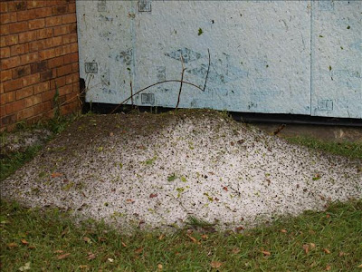 </div><div>This was hail the next afternoon! It wasn't even melted thats how thick it was...It was crazy!</div>
Not the weather stuff, I defer to you on that and take it for all its worth.
I am talking about dumbass Tony Mastro and the rest of WJTV 12. Like you said there was some instability (some is a very generous word) Saturday during the games. However, there was no 17ing reason for them to run the scroll the entire 7 hours. A simple map would have sufficed. All the scroll did was list the counties affected and informed them that there was a tornado watch in effect until 10 pm that night, they did this IN ADDITION to keeping the map and their VIPER weather logo up the entire 17ing time. The combination of those covered the BASKETS, which are important in BASKETball.
Would it have killed them to turn off the scroll and just leave the map and their gay Viper logo up? I understand warning people but they had no reason to leave the scroll up for 7 hours STRAIGHT essentially killing the viewing pleasure of those games. If you can't pick out your county on a map of Mississippi natural selection dictates you should go anyway. But, in all this keep in mind in Madison county one of the affected counties IT WAS SUNNY for all 7 hours the 17ing WATCH (not WARNING) lasted.
Don't take your job too seriously all the time. Know when to back off on the warnings. Don't be obtrusive to your programming unless the situation is DIRE like you know an actual 17ing Tornado Warning!!!!!!!!!!!!
Rant over.
I agree a simple map would be better...BTW I don't do anything w/ TV thats for Mastro and all and the broadcast meteorologists that graduate from MSU, as I graduated in operational meteorology...I will eventually be the one issuing the warning someday, which is not what Mastro does. He gives information that our office relays to them...Our office issues warnings and collaborates w/ the SPC over watch areas..I'll say this, though...I'm not at all hyping this Monday cause the forcing is much better as its not through Arkansas, but the heart of MS...We'll see though but its looking pretty rough on Monday...That will be a day where breaking in will pretty much need to be done, if it pans out...I agree that the scrolling stuff added to everything else can be very distracting so I agree w/ you on that...
Has there been a statistical jump in the number of weather-related deaths since everybody got cable or satellite? Because out of the hundreds of channels available now, only three of them go all out to warn you when your life is (in their opinion) in imminent danger. Sure, there's some other channels that you can go to if you hear thunder and you're curious, but where are all the dead people that were caught unawares in bad weather because they were watching ESPN or the Kardashians?
Last Saturday was a confusing scenario..All the forcing went through Memphis but there was over 2500 CAPE here in Starkville along that warm front..Southwesterly winds made me think nah tornado watch should not have been warranted as thats not that great...But the instability of 2500 is significant..Why storms initiated more in Alabama than here I'm not sure but when they initiated and went into Alabama and even in North MS, they produced massive hail and rotated quite a bit in Alabama...We were very lucky that we didn't get hit by a storm just north of Columbus produced large hail just to our northeast and tracked into Alabama and became a hook echo that produced a wall cloud that almost produced a tornado...We were very lucky to be just to the south of that warm front... There was a report of over 3 inch hail in Alabama and 4.25 inch hail in Georgia. So yeah my forecast of large hail was warranted as the NWS also forecast this.<div>
 </div><div><table cellspacing="5" cellpadding="0" width="525" border="0" style="font-family: Arial, Helvetica, sans-serif; font-size: 12px; "><tbody><tr><td class="rpttext" style="font-size: 8pt; font-family: monospace; ">1955</td><td class="rpttext" style="font-size: 8pt; font-family: monospace; ">425</td><td class="rpttext" style="font-size: 8pt; font-family: monospace; ">9 W SENOIA</td><td class="rpttext" style="font-size: 8pt; font-family: monospace; ">COWETA</td><td class="rpttext" style="font-size: 8pt; font-family: monospace; ">GA</td><td class="rpttext" style="font-size: 8pt; font-family: monospace; ">3331</td><td class="rpttext" style="font-size: 8pt; font-family: monospace; ">8471</td><td class="rpttext" style="font-size: 8pt; font-family: monospace; ">(FFC)
</td></tr></tbody></table><table cellspacing="5" cellpadding="0" width="525" border="0" style="font-family: Arial, Helvetica, sans-serif; font-size: 12px; "><tbody><tr><td class="rpttext" style="font-size: 8pt; font-family: monospace; ">2005</td><td class="rpttext" style="font-size: 8pt; font-family: monospace; ">300</td><td class="rpttext" style="font-size: 8pt; font-family: monospace; ">EAGLE CREEK</td><td class="rpttext" style="font-size: 8pt; font-family: monospace; ">TALLAPOOSA</td><td class="rpttext" style="font-size: 8pt; font-family: monospace; ">AL</td><td class="rpttext" style="font-size: 8pt; font-family: monospace; ">3294</td><td class="rpttext" style="font-size: 8pt; font-family: monospace; ">8575</td><td class="rpttext" style="font-size: 8pt; font-family: monospace; ">THREE AND ONE HALF INCH HAIL.(BMX)</td></tr></tbody></table>
</div><div>So I wasn't kidding when I said it was producing very large hail. That system on Saturday all the forcing went through Memphis and north so I was still skeptical of it but w/ 2500 CAPE and an erosion of the cap, all the forecasters around believed we were going to get something at least...But this system on Monday there is a strong forcing feature coming through all of MS so I'm fairly confident in a severe weather event Monday for our area..</div>
Thats a strong trough..The yellows and red are called highe vorticity or rotation in the atmosphere..They pretty much get storm systems going at the surface..The stronger the vorticity and the winds crossing that area of vorticity, the stronger the surface system will be. This is about 17,000 feet up in the atmosphere..Anywho, when the troughs move through Arkansas, like they have lately, its a much tougher forecast than when it comes plowing into MS. Seeing this run after run, consistently, I'm pretty confident in a severe weather event on Monday for all of MS. This is 12UTC, or 12Z or 7AM on Tuesday...It would likely be an overnight event if the GFS forecast pans out...This is how we make forecasts btw w/ many maps of many levels of the atmosphere...Just one of many things we use..<div>
 </div>
Those places attract tornados, hail, sleet,etc. It'd be news if NOTHING happened there.msubulldog0610 said:..But I understand you being upset but there was massive hail the other day. Reports of tennis ball size hail in Simpson County and my parents and girlfriend in Florence and Richland, respectively, got pea size hail. The hail was golf ball size and some places was between 4inches to 1 foot deep near Crystal Springs!
<div></div><div>This was hail the next afternoon! It wasn't even melted thats how thick it was...It was crazy!</div>
viper 17ing radar. LOL. they could have given the info in 2 minutes and done just as much good as going over, and over, and over, and over, and.......well nevermind.
the weather, the weather, whats it gonna be? Here is Ready Killowatt, to show you on TV!
Somehow I can remember that from when I was a kid. And it is/was really as awful as it sounds! Even worse, all of us, as their customers, paid for that!@#@
Somehow I can remember that from when I was a kid. And it is/was really as awful as it sounds! Even worse, all of us, as their customers, paid for that!@#@