Mississippi River flooding update...

Nov 16, 2005
27,032
19,438
113
All the crests have been bumped up yet again. Memphis is now forecast to crest at 48 feet which is up from I believe 45 feet. There will be serious flooding in and around Memphis.

It appears that about 2 miles of the levee in Missouri will be blown up sometime within the next day or so by the Corp of Engineers. It doesn't matter if the did blow it up not because they are forecasting the river to crest 2 inches higher than what the Missouri levee can hold. Its going over one way or another and will flood thousands and thousands of acres of farmland in the bootheel of MO and even parts of NE Arkansas.
 
Nov 16, 2005
27,032
19,438
113


</p>
 

WP4

Redshirt
Sep 2, 2010
81
0
0
Where this levee is all but inevitably going to be blown. It's scary and it's real. My parents live just a couple hundred yards on the "safe" side of the secondary levee and I'm stressed the 17 out about it. I'm in Memphis and have been stir crazy all day, can't imagine what everyone back home is feeling. They've got national guard in their front yard making sure no one enters the spillway. The worst part is all of the unknowns. I mean who's to say that the secondary levee will hold, hasn't been tested since the 1937 flood.

As I'm typing, Dad just texted....Army Corps of Engineers planning on blowing the levee at 9 pm tonight. I told him to get the hell out of there.
 

AssEndDawg

Freshman
Aug 1, 2007
3,183
54
48
I believe the previous record was 47.1 feet so this will be something we haven't seen in modern times. Scary stuff.
 

maroonmadman

Senior
Nov 7, 2010
2,530
853
113
They live in the Eagle lake area and have been packing up and buggin out since last week. Good luck to you folks who live along old man river.
 

dudehead

Senior
Jul 9, 2006
1,515
575
113
What does "latest stage" on the map mean? I tried google but had no luck (plus I'm lazy).
 

WP4

Redshirt
Sep 2, 2010
81
0
0
It's really heartbreaking knowing what some people are going to have to deal with.
 
Nov 16, 2005
27,032
19,438
113
Alot of that farmland that will be flooded will not be farmed for years because of the amount of silt that will be dumped onto it. It will fill up all the ditches and streams that drain the land. Incredibly sad to see. Those farmers lives will be forever changed by this.
 

thatsbaseball

All-American
May 29, 2007
17,776
6,381
113
webpage regularly with all kinds of info. This has all the markings of a potentiallyhuge disaster.
 

WP4

Redshirt
Sep 2, 2010
81
0
0
Was one of the more overwhelming moments of my life and I was just watching the live feed online.I can't imagine being back home. Just knowing that at that moment the entire physical, economical, and emotional landscape of my hometown was just changed for what could be forever. It was intense to see. The blast was felt as far away as Dexter, MO and Paducah, KY.
 

AssEndDawg

Freshman
Aug 1, 2007
3,183
54
48
"If you have ever flooded before, you are going to flood now." Just a good way of keeping people from trying to wait it out if they have seen this kind of thing before. Hell, I'm getting nervous even though I know there is no way my house can flood. It's starting to get to me.
 

AssEndDawg

Freshman
Aug 1, 2007
3,183
54
48
WP4 said:
Was one of the more overwhelming moments of my life and I was just watching the live feed online.I can't imagine being back home. Just knowing that at that moment the entire physical, economical, and emotional landscape of my hometown was just changed for what could be forever. It was intense to see. The blast was felt as far away as Dexter, MO and Paducah, KY.
And the craziest thing is that this isn't going to do anything for the current river predictions. They are doing this to allow the reservoirs upstream on the Mississippi and Missouri rivers release their water holds. They said it would have very little and probably no effect on the crest estimates. There is simply more water in the watershed than we have ever seen. Of course as I type this it is still pouring rain in Memphis...

I really hate it for the farmers in MO. I don't think this is going to be the only levee system they take out during this thing.
 

dudehead

Senior
Jul 9, 2006
1,515
575
113
I have family in Helena and Clarksdale and was thinking about you folks this evening. I can't imagine this slow wait on potential devastation. That's weird and spooky in a strange way. I wish you all the best.
 
Nov 16, 2005
27,032
19,438
113
http://www.k5jaw.com/2011/05/ms-river-flooding-522011.html?spref=fb

<h2 class="date-header"><span>Monday, May 2, 2011</span></h2>

<a name="7697569214705791132"></a><h3 class="post-title entry-title">
MS River Flooding - 5/2/2011
</h3><div class="post-header">

</div><div class="post-body entry-content">
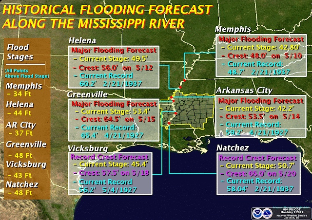
The Mississippi River is expected to crest very near 1927 record flood
levels in the coming weeks. A river stage forecast is included at the
end of this email for reference. Arkansas City is currently expected to
crest on 5/14/11 at 53.5ft. Arkansas City record flood was 4/21/1927 at 59.2ft. The river at Greenville, MS is expected to crest on 5/15/11
at 64.5ft. The record stage there was 4/21/1927 at 65.4ft. These are
crest dates only. There will be a rise prior to, and a fall after the
crest date.

While difficult to predict, some areas could remain flooded for 30 days.

The potential problem for a large portion of the Delta comes not from
the Mississippi River, but from the Yazoo River. Some geography
first: Areas generally west of Indianola are drained by streams that
empty into the Yazoo River through Steele Bayou north of Vicksburg.
Floodgates on Steele Bayou are closed, keeping the Mississippi from
backing up stream.

The Yazoo River, however, is not gated, and therefore empties directly
into the Mississippi at Vicksburg. With the Mississippi River forecast
to go so high, it will back up into the Yazoo Basin. Areas to the
east and south of the immediate Indianola area are drained by the
Yazoo.

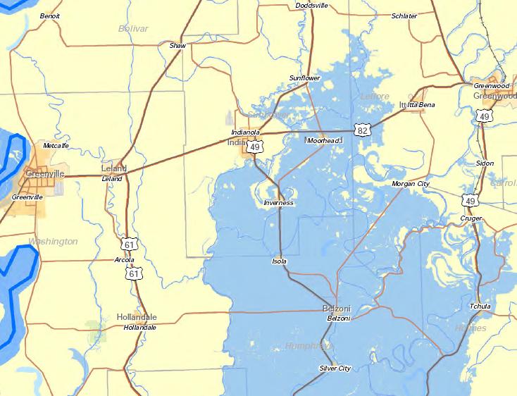
This image was produced over the weekend, when flood stages were
predicted to be lower. It illustrates the projected maximum area of
flooding from Yazoo backwater. NOTE: This is a projection only, and is being revised, and will likely include more areas.
There is no way to predict flooding on a street-by-street level, as
roadways, highways, and other features may block waters in any given
area. Blue areas are forecast flood areas. (More text following
picture)
<div class="separator" style="clear: both; text-align: center;"> </div>
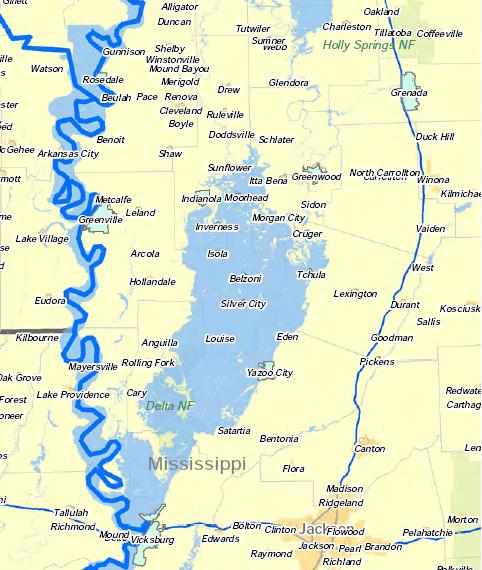
This next image illustrates the full Delta area (more text following picture).
<div class="separator" style="clear: both; text-align: center;"> </div>


I do NOT wish to sound alarmist. I cannot ever recall seeing flood
projections like this for the heart of the Delta. I encourage you to
begin work today to take whatever steps necessary to protect you
valuables, your homes, and you family. Granted, these floods may not
materialize, and may not be terribly deep. But we certainly could
expect to see issues develop regarding infrastructure (transportation -
road closures, possible water/sewer issues, etc.)

Other things you can consider:
  • Drinking water - 1 gallon per person, per day. One case of 16oz water (24 bottles) is enough for 3 people per day.
  • Non-perishable, high-energy foods (anybody in the family have special diets?)
  • Cash-on-hand, should power be lost.
  • Battery-powered lights & radios
  • Well-documented medical information (medical history, current prescriptions, etc).
  • Adequate supply of prescription medications
  • Pets? Relocate them to family outside of the area?
There are a host of online resources for more information on family disaster planning. You can start with http://www.ready.gov/america/<wbr>beinformed/floods.html

The graphic below illustrates the current forecast for Mississippi
River stages. No further text occurs beyond the image. I'll provide
you another update as more information becomes available.

<div class="separator" style="clear: both; text-align: center;"> </div>
<div style="color: red;"><span style="font-size: x-small;">***DO NOT USE
THIS WEBSITE AS YOUR SOLE SOURCE OF WEATHER INFORMATION, ESPECIALLY
WATCHES AND WARNINGS. THIS WEBSITE DELIVERS FOCUSED INFORMATION FOR A
SPECIFIC GEOGRAPHIC AREA AND IS NOT INTENDED TO PROVIDE TIMELY WEATHER
WARNING INFORMATION***</span></div>

</div>

<span class="post-author vcard">
Posted by
<span class="fn">Jim Whitfield</span></span><span class="post-timestamp">
at
<abbr class="published" title="2011-05-02T21:54:00-05:00">9:54 PM</abbr>
</span><span class="post-comment-link"></span>
 

coach66

Junior
Mar 5, 2009
12,679
289
83
Levee board yesterday and he said he believed the pumps would keep everything on the East side of the Yazoo River dry. He said the further south you went toward Vicksburg on the west side of the Yazoo the more problems you were going to have. He said it was going to be close even on the east side of the Yazoo. History in the making!</p>
 

fishwater99

Freshman
Jun 4, 2007
14,072
54
48
It is really going to be bad for many Delta Towns....

<h6 class="uiStreamMessage"><span class="messageBody">UPDATE – May 3, 2011
The
overtopping of the Yazoo Backwater (YBW) Levee might only last for a
week – if the River doesn’t go any higher and the duration doesn’t last
longer and the levee doesn’t breach – it will inundate the YBW Area up
to 95’ with normal rainfall.

If the River goes up higher and the duration last longer this number co<span class="text_exposed_show">uld go up to as high as 107’. If the levee breaches it could go up to 107’.

The YBW Levee is predicted to be overtopped around May 15th.
Sorry to scare everyone with my incorrect 109’ elevation yesterday.

Levee
will be CLOSED to everyone starting at Saturday night at Midnight. No
exceptions! Only Levee Board, Corps of Engineers, Highwater Inspectors,
Game Wardens & Law Enforcement Officers will be allowed on top.
Anyone else will be arrested.

Peter Nimrod
Chief Engineer
MS Levee Board
(662)334-4813
(662)378-9592 fax
[email protected]</span></span></h6>
 

coach66

Junior
Mar 5, 2009
12,679
289
83
much jives with what Fishwater just posted, it seems that 107' mark is the target elevation for peak water right now. Our place on the Yazoo River at Eden is around 108' to 109' feet I believe.
 

coach66

Junior
Mar 5, 2009
12,679
289
83
City as a crow flies. Here is what the levee board gentlmen said below:

<p class="MsoNormal" style="MARGIN: 0in 0in 0pt"><span style="FONT-SIZE: 10pt; COLOR: navy; FONT-FAMILY: 'Arial','sans-serif'">Steve,</span></p>

</p><p class="MsoNormal" style="MARGIN: 0in 0in 0pt"><span style="FONT-SIZE: 10pt; COLOR: navy; FONT-FAMILY: 'Arial','sans-serif'">I would guess Eden is 112’ +. Your property will be a few feet lower than Eden. Normal rainfall, with the operation of Drainage District’s backwater pumps should protect all structures and most crops in the Eden watershed. This will be a Ms. River flood and not a Yazoo River flood. Obviously, the closer you get to Vicksburg the more influence the Ms has on the Yazoo. All resources and concerns, at this time, are focused on the area West of the Yazoo and closer to Vicksburg. Inundation maps should be out today, based on yesterday’s forecast. We probably will not be a part of that coverage.</span></p>

</p><p class="MsoNormal" style="MARGIN: 0in 0in 0pt"><span style="FONT-SIZE: 10pt; COLOR: navy; FONT-FAMILY: 'Arial','sans-serif'"></span></p>

</p><p class="MsoNormal" style="MARGIN: 0in 0in 0pt"><span style="FONT-SIZE: 10pt; COLOR: navy; FONT-FAMILY: 'Arial','sans-serif'">I must spend a little time on the Eden watershed, over the next couple of days, if anything changes I will let you know. If you need an exact elevation, an engineer would be needed and everyone I know is working in the projected flood area. </span></p>

</p><p class="MsoNormal" style="MARGIN: 0in 0in 0pt"><span style="FONT-SIZE: 10pt; COLOR: navy; FONT-FAMILY: 'Arial','sans-serif'"></span></p>

</p>
 

MarydelHiskey

Redshirt
May 13, 2011
5
0
0
Do any of you know if the catfish farms west of Eden on Money Sunk road have flooded? I spent every spare moment of my childhood on with my aunt and uncle Chat and Louise Phillips on that land in the bend of the river there.
 

coach66

Junior
Mar 5, 2009
12,679
289
83
The east side of the river. If levee breaks then you know how the song goes.
 

MarydelHiskey

Redshirt
May 13, 2011
5
0
0
Thanks, coach66,

Is Jack's land dry on the other side? I heard on one internet report that there was some flooding in Carter. Wow, small world. I'm up here in Longmont, Colorado and there you are where I spent so many happy summers.

Md
 

MarydelHiskey

Redshirt
May 13, 2011
5
0
0
If the levee breaks, Chat's house will be flooded, too. You know how it sits right beside the levee. I used to keep my horse on that levee, and that's where the washwoman had her big black pot. I'm showing my age now.
 

thatsbaseball

All-American
May 29, 2007
17,776
6,381
113
Water isstarting to fill the ditches in town. Won`t be long now.The big difference in this year and 73 is this year the water is coming in from the south and will be about 4 feet deeper. About half the homes have levees around them.
 

MarydelHiskey

Redshirt
May 13, 2011
5
0
0
Dear Coach66,

Crest today at Vicksburg; How is you land; the Chat Phillips property at Belle Prairie next to yours and the Jack Phillips property on the other side? Delta Council photos near Carterand 49 W look awful, expectedly. I pray ya'll don't have lots of catfish swimming free! A friend of mine in Greenville says there are live deer trapped intrees and a gator or two spotted next to the levee. That's pretty far north for gators.
 

coach66

Junior
Mar 5, 2009
12,679
289
83
I did not make it to Eden. I hear all is well on east side
Of levee. I saw several flood pictures from vicksburg today with some rather large gators. Folks might want to
Be carefulcrawfishing as water recedes.