OT: The Summer Weather Thread: Is Summer "Over?"

RU848789

Well-known member
Jul 27, 2001
64,182
43,310
113
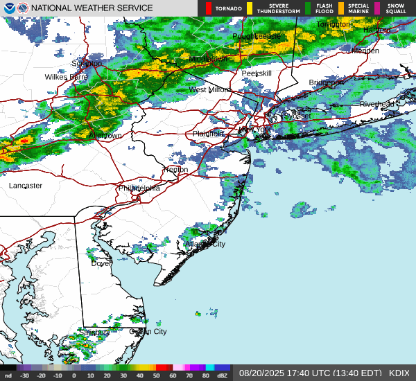
Heads up folks - tornado warnings currently in EPA, heading towards Mercer and Hunterdon Counties and maybe further than that with severe t-storm watches up for the whole Philly-NJ-NYC region, which could bring high winds, lightning and heavy downpours in some locations (as always impossible to predict where mesoscale events like these will occur). Could see a repeat tomorrow afternoon, as the atmosphere is tropical with very high precipitable water amounts in the column due to heat and high humidity and we have a forcing mechanism to set off storms (the approaching "cold" front). Stay safe out there folks. Will use this thread and change the title as needed for specific summertime threats, mostly for storms.

https://www.weather.gov/phi
 
Last edited:

RU848789

Well-known member
Jul 27, 2001
64,182
43,310
113
Well, while the 2 tornado warnings were just dropped, a new one was just issued for SW of Trenton in PA (the red splotch on the map). Could be a crazy day.

No photo description available.
 

RU848789

Well-known member
Jul 27, 2001
64,182
43,310
113
We should also create a consolidated RIP/death thread. New board, new rules! :)
Agree on a consolidated RIP thread, but many won't like just one weather thread, as you know, but for summertime threats, which can be almost every day, it makes sense to me.
 
  • Like
Reactions: T2Kplus20

T2Kplus20

Well-known member
May 1, 2007
29,835
17,802
113

ClassOf02v.2

Well-known member
Sep 30, 2010
13,408
14,574
103
Nasty line of storms, radar shows that the worst of it just passed through southern Hunterdon (near New Hope PA).
 

Postman_1

Well-known member
Mar 12, 2017
6,929
11,271
113
Ended up with 0.32” in Hamilton. Lots of lighting was going on
 

e5fdny

Well-known member
Nov 11, 2002
96,385
44,278
102
I was watching my Ring cam at work...looked like my neighbor's tree was coming down with the wind.

Interested to see if my sprinklers go on tomorrow morning or the sensor says...ya got enough for the day.
 

RU848789

Well-known member
Jul 27, 2001
64,182
43,310
113
Nasty line of storms, radar shows that the worst of it just passed through southern Hunterdon (near New Hope PA).
Yeah, the worst of it ended up staying south of about a New Hope to Sandy Hook (where there was a 63 mph gust) line.
 

RU848789

Well-known member
Jul 27, 2001
64,182
43,310
113
16 of the last 21 days in Newark have seen high temps of 90+F, including 4 days of 100F+ highs, which is pretty unusual. Fortunately, no major heat waves in the cards for the next ~10 days (will still likely be warm and often humid with lots of chances for t-storms, but that's summer).
 
  • Haha
Reactions: Caliknight

T2Kplus20

Well-known member
May 1, 2007
29,835
17,802
113
16 of the last 21 days in Newark have seen high temps of 90+F, including 4 days of 100F+ highs, which is pretty unusual. Fortunately, no major heat waves in the cards for the next ~10 days (will still likely be warm and often humid with lots of chances for t-storms, but that's summer).
 

RU848789

Well-known member
Jul 27, 2001
64,182
43,310
113
Big, severe t-storms with high winds, frequent lightning, and torrential, possibly flooding downpours (with flash flood warnings in dark red in the map below and more might come) from DC to about Trenton right now, including northern DE, most of SEPA and SW parts of SNJ with at least SW parts of CNJ likely under the gun. The severe t-storm watch only goes up to about 78, so most of NNJ/NYC Metro will likely escape significant storms (and we might also escape them in northern Middlesex County).

https://www.weather.gov/phi


1752106091265.png
 
Last edited:
  • Haha
Reactions: Caliknight

RU848789

Well-known member
Jul 27, 2001
64,182
43,310
113
Looks like some heavy but not quite severe storms are making it up to 78. Also a tornado warning was just issues for Middletown DE area, where our poster YesRutgerslsjdlfasjlfkdadlf (can't recall the exact name, now, lol) moved to. And the flash flood warnings have been extended up to the Trenton area - some significant flooding going on now.

Severe Weather Statement
National Weather Service Mount Holly NJ
905 PM EDT Wed Jul 9 2025

DEC003-100115-
/O.CON.KPHI.TO.W.0025.000000T0000Z-250710T0115Z/
New Castle DE-
905 PM EDT Wed Jul 9 2025

...A TORNADO WARNING REMAINS IN EFFECT UNTIL 915 PM EDT FOR
SOUTHWESTERN NEW CASTLE COUNTY...

At 905 PM EDT, a severe thunderstorm capable of producing a tornado
was located near Green Spring, or near Middletown, moving northeast
at 20 mph.

HAZARD...Tornado.

SOURCE...Radar indicated rotation.

IMPACT...Flying debris will be dangerous to those caught without
shelter. Mobile homes will be damaged or destroyed. Damage
to roofs, windows, and vehicles will occur. Tree damage is
likely.

Locations impacted include...
Middletown and Townsend.
 

RU848789

Well-known member
Jul 27, 2001
64,182
43,310
113
Looks like NNJ/NYC Metro aren't going to escape.
They're not going to escape rain, but nobody thought they were - they are, now, very likely to escape severe t-storms, as is everywhere along/N of 78, as the severe t-storm watches have been dropped for everyone except along/SE of 95.

1752113270925.png
 
  • Like
Reactions: bac2therac

mdk02

Well-known member
Aug 18, 2011
25,732
18,177
113
They're not going to escape rain, but nobody thought they were - they are, now, very likely to escape severe t-storms, as is everywhere along/N of 78, as the severe t-storm watches have been dropped for everyone except along/SE of 95.

View attachment 840144

Apparently things have changed since that 8:37 radar shot
 

bac2therac

Well-known member
Jul 30, 2001
236,144
165,376
113
Got only .32 IMBY as the heavy rains focused south of I95 and 2 inch amounts well south of that

Pretty nice summery weekend coming up. Mix of sun and clouds warm humid highs in mid to upper 80s with perhaps a thundershower in the afternoon but nothing to postpone plans . Next week another heat pulse and heat wave possible
 
Last edited:

RULoyal

Well-known member
Jul 28, 2001
14,452
16,825
113
Got only .32 IMBY as the heavy rains focused south of I95 and 2 inch amounts well south of that

Pretty nice summery weekend coming up. Mix of sun and clouds warm humid highs in mid to upper 80s with perhaps a thundershower in the afternoon but nothing to postpone plans . Next week another heat pulse and heat wave possible
Not much in So. Bruns. probably similar.
 

RU848789

Well-known member
Jul 27, 2001
64,182
43,310
113
Flood watches are up for most of our region from the NWS and the WPC (Weather Prediction Center) has much of the area, especially along/NW of 95 in NJ/PA/DE, under a "moderate" risk of excessive rainfall with 3-5" possible from heavy downpours from t-storms from mid-afternoon through late evening for the areas in pink in the graphic below. Keep in mind, though, that predicting mesoscale storms is extremely difficult, so it's very possible some areas in the pink shading will get 1" or less of rain while other areas will get the 3-5" - and it's also possible that 3-5" amounts could easily be seen outside of the pink shaded area. The flooding risks are also exacerbated by the recent heavy rains for most of the area, meaning soils are saturated and streams/rivers are already at high levels, such that it will take less rain than usual to lead to urban/stream/river flooding. The rest of the week will continue with warm/hot and humid conditions with more heavy downpours possible in some locations, typically in the afternoon/evening after the atmosphere heats up and destabilizes.


RU848789

Well-known member
Jul 27, 2001
64,182
43,310
113

Wow, they got that wrong. There's a flood watch in effect statewide for tonight, but not a flash flood warning, as those are issued when flash flooding is imminent or ongoing and that's only the case, currently, for much of Union to Bergen and most of Warren as per the map (deep red areas).

1752526950086.png
 
  • Like
Reactions: Knight Shift

bac2therac

Well-known member
Jul 30, 2001
236,144
165,376
113
Quick gullywasher here imby out of nowhere but for now main focus is n nj...that likely to change as we go through the next several hours

Keep your eye to the sky
 
  • Like
Reactions: Knight Shift

bac2therac

Well-known member
Jul 30, 2001
236,144
165,376
113
Flash flood warning much of central jersey..2 inches plus rain has fallen i. An hour

Getting pummeled now and its way worse than radar indicates

Pray for those on the roads
 
  • Like
Reactions: runrutgersrun

RU848789

Well-known member
Jul 27, 2001
64,182
43,310
113
It's a torrential deluge out there in Middlesex County and many other locations. Could easily see 2-5" at this rate in many locations, which is why so many flash flood warnings are already up - the dark red counties..

1752532455034.png
 
  • Like
Reactions: runrutgersrun