It says .3 in your post, but then I reply to your post and it says .1.
Is there an edit in there somewhere?
Sigh.
It says .3 in your post, but then I reply to your post and it says .1.
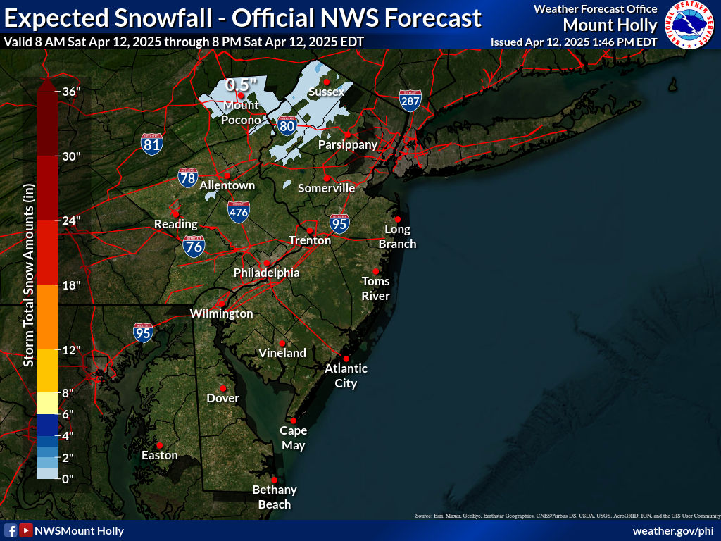
Why are you posting snowfall maps from yesterday? For those interested, here's the latest snowfall map, showing <1" of snow or the area tomorrow (and really, <0.3" for most if you dive into their details). However, most of the models (especially the short range mesoscale models that should do better with this mesoscale event, are now showing snow showers and/or periods of light snow for most from about 4 pm through midnight tomorrow, especially N of 276/195, with 1/4-3/4" of light powdery snow for most, but with some spots getting 1"+ where the heavier bands hit from the upper level low approaching from the NW.


bac apparently posted the wrong graphic from yesterday, this evening, but these source graphics are "live" meaning one will eventually see the current graphic from today (and if one looked at a graphic posted a month ago for a different storm in an old thread, right now it would show the current NWS graphic). That's why I go through the extra step of posting all my graphics to a hosting site (imgur), so that they're no longer "live" graphics. Although to be fair, in this case, there's not a lot of difference between 0.1 and 0.3" lol...It says .3 in your post, but then I reply to your post and it says .1.
Is there an edit in there somewhere?
Sigh.
Had dinner at Federico's in Belmar next to St. Rose HS last night around 7:00pm. The wind was incredible to say the least. On my phone it said wind gust were hitting 65+, crazy. PS. They have the best chicken Francese

People making maps with tenths of a % is beyond silly!bac apparently posted the wrong graphic from yesterday, this evening, but these source graphics are "live" meaning one will eventually see the current graphic from today (and if one looked at a graphic posted a month ago for a different storm in an old thread, right now it would show the current NWS graphic). That's why I go through the extra step of posting all my graphics to a hosting site (imgur), so that they're no longer "live" graphics. Although to be fair, in this case, there's not a lot of difference between 0.1 and 0.3" lol...
Well done! You earned it.Did that Dr. reschedule all those appointments that he was going to do after reading numbers doomsday snow from Saturday?¹
")

Did that Dr. reschedule all those appointments that he was going to do after reading numbers doomsday snow from Saturday?¹


Are you really going to deny that you're clueless with regard to how to post "current" graphics? We've covered numerous times how the NWS snowfall maps are "live" graphics that update at some point after the NWS changes the graphic. Right now your two posts on page 6, from Monday at 11:34 pm and last night at 6:40 pm, both show graphics showing they were "issued Feb 19th, 2025 at 9:46 pm," which means either you are able to post maps well into the future or I'm right.Imagine quibbling over a non event map and accusing me of the posting an outdated graphic while I posted the actual current map
You've been running around like a crazy person over snowshowers
I think he's triggered.Are you really going to deny that you're clueless with regard to how to post "current" graphics? We've covered numerous times how the NWS snowfall maps are "live" graphics that update at some point after the NWS changes the graphic. Right now your two posts on page 6, from Monday at 11:34 pm and last night at 6:40 pm, both show graphics showing they were "issued Feb 19th, 2025 at 9:46 pm," which means either you are able to post maps well into the future or I'm right.
And they'll both probably soon show the updated graphics from this morning. Every one of my NWS graphics still shows the original graphic from that time. Also, you did erroneously post the graphic from Tuesday night in your post last night, but now it shows the graphic from 9:46 pm last night in your post from 6:40 pm last night and any NWS graphic you've posted in the past now shows the most recent or a very recent snowfall map, like your post on the 2/6 storm also shows last night's NWS graphic.
https://rutgers.forums.rivals.com/t...n-rain-likely-until-12-pm.288790/post-7125742
It doesn't really matter much for this storm, but for a real storm with changing snowfall maps from the NWS it leads to misinformation and confusion. If you can't figure out how to post maps that don't change, you shouldn't post any maps at all from the NWS in these threads.
That would be impressive and at least they would get used. Good for promoting the brand too.Oh what could have been.... Until next time. Someone with a truck should sponsor a road trip to the jackpot zone and take a bunch of guys and their snowblowers. We could roll in like line repairmen, but with white R magnets on our red snowblowers.
Aren't you specialAre you really going to deny that you're clueless with regard to how to post "current" graphics? We've covered numerous times how the NWS snowfall maps are "live" graphics that update at some point after the NWS changes the graphic. Right now your two posts on page 6, from Monday at 11:34 pm and last night at 6:40 pm, both show graphics showing they were "issued Feb 19th, 2025 at 9:46 pm," which means either you are able to post maps well into the future or I'm right.
And they'll both probably soon show the updated graphics from this morning. Every one of my NWS graphics still shows the original graphic from that time. Also, you did erroneously post the graphic from Tuesday night in your post last night, but now it shows the graphic from 9:46 pm last night in your post from 6:40 pm last night and any NWS graphic you've posted in the past now shows the most recent or a very recent snowfall map, like your post on the 2/6 storm also shows last night's NWS graphic.
https://rutgers.forums.rivals.com/t...n-rain-likely-until-12-pm.288790/post-7125742
It doesn't really matter much for this storm, but for a real storm with changing snowfall maps from the NWS it leads to misinformation and confusion. If you can't figure out how to post maps that don't change, you shouldn't post any maps at all from the NWS in these threads.
Time to upgrade! The kids love this:Oh what could have been.... Until next time. Someone with a truck should sponsor a road trip to the jackpot zone and take a bunch of guys and their snowblowers. We could roll in like line repairmen, but with white R magnets on our red snowblowers.
School bus special. Like knocking over kids at a college basketball game to desperately get a free t-shirt.Aren't you special
7 page thread on a non event that was modeled as such by Sunday Afternoon
Talk about "misinformation and confusion'" You were hinting at a historical storm. last week. Dr's were taking ur info and rescheduling appointments for yesterday and today and possibly tomorrow,Are you really going to deny that you're clueless with regard to how to post "current" graphics? We've covered numerous times how the NWS snowfall maps are "live" graphics that update at some point after the NWS changes the graphic. Right now your two posts on page 6, from Monday at 11:34 pm and last night at 6:40 pm, both show graphics showing they were "issued Feb 19th, 2025 at 9:46 pm," which means either you are able to post maps well into the future or I'm right.
And they'll both probably soon show the updated graphics from this morning. Every one of my NWS graphics still shows the original graphic from that time. Also, you did erroneously post the graphic from Tuesday night in your post last night, but now it shows the graphic from 9:46 pm last night in your post from 6:40 pm last night and any NWS graphic you've posted in the past now shows the most recent or a very recent snowfall map, like your post on the 2/6 storm also shows last night's NWS graphic.
https://rutgers.forums.rivals.com/t...n-rain-likely-until-12-pm.288790/post-7125742
It doesn't really matter much for this storm, but for a real storm with changing snowfall maps from the NWS it leads to misinformation and confusion. If you can't figure out how to post maps that don't change, you shouldn't post any maps at all from the NWS in these threads.
I'm not sure what's more disturbing - the flame thrower or the bathrobe/boots look.Time to upgrade! The kids love this:
How dare you question the accuracy of 7 day model run...EVERY snow weenie poster on americanwx.com said it was unprecedented...don't you know what that meansTalk about "misinformation and confusion'" You were hinting at a historical storm. last week. Dr's were taking ur info and rescheduling appointments for yesterday and today and possibly tomorrow
That's crazy - thought they would see something significant out of this. Well, I guess 4 inches is somewhat significant for Richmond.This storm really underperformed down south also: Tyler got all of an inch or so, although the schools closed yesterday and today up until noon; my friend SE of Richmond, in the 6-7 inch projected zone, did get about 4 inches. Schools are closed until further notice down there.
Why are you posting snowfall maps from yesterday? For those interested, here's the latest snowfall map, showing <1" of snow or the area tomorrow (and really, <0.3" for most if you dive into their details). However, most of the models (especially the short range mesoscale models that should do better with this mesoscale event, are now showing snow showers and/or periods of light snow for most from about 4 pm through midnight tomorrow, especially N of 276/195, with 1/4-3/4" of light powdery snow for most, but with some spots getting 1"+ where the heavier bands hit from the upper level low approaching from the NW.
For these kinds of mesoscale events, it's nearly impossible to know who might get 1/4" and who might get 1"+ (much like it's usually impossible to know where summertime showers and t-storms will hit). None of this will have much impact, although anywhere that gets more than maybe 1/2" of snow will likely have slippery spots on untreated side roads, sidewalks and driveways, as temps will be in the upper 20s. Of course, it's also still possible that most will get 1/4" or even nada, as these systems are difficult to forecast.
Personally, I think the NWS is a bit underdone on this with <0.3" snow for most, given the model outputs I just mentioned and Lee Goldberg clearly agrees, as per the 2nd map below showing widespread 0.5-1" amounts N of 276/195. He also mentioned how predicting who gets more and who gets less in this setup is nearly impossible.

Nice deflection from your inability to post correct NWS maps. I could teach you how to do that if you like. It might take a few hours given how challenged you are with anything remotely scientific, but I'm wiling to put the time in.Aren't you special
7 page thread on a non event that was modeled as such by Sunday Afternoon
Maybe you shouldn't post maps at all from model sites on this thread lest there be misinformation and confusion
I hope that doctor didn't cancel his appointments
Way less than DT/WxRisk and the NWS forecasted, but still significant. It happens. Here's a better snowfall map than the one I posted above, for the eastern VA/NC and southern MD/DE region.That's crazy - thought they would see something significant out of this. Well, I guess 4 inches is somewhat significant for Richmond.

To summarize (not even worthy of the bouncy kind):Way less than DT/WxRisk and the NWS forecasted, but still significant. It happens. Here's a better snowfall map than the one I posted above, for the eastern VA/NC and southern MD/DE region.

Yeah, that's just bad. You might get a dusting later today.My local radio station is saying 2-5 inches today??? Are they also broadcasting old news?
accuweather also saying 2-4 inchesYeah, that's just bad. You might get a dusting later today.
That's almost criminally bad and wrong...accuweather also saying 2-4 inches
Yet here you are discussing.Light flurries with bright skies
Low bar for discussion
He refused to do a bacetology analysis for the BIG Ten tournament for out most hyped men’s basketball team everYet here you are discussing.


