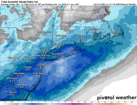
OT: Moderate to Significant Snowfall Incoming for Late Sat through Sunday Morning (12/14)

RU848789

Heisman
Jul 27, 2001
64,486
43,595
113
Summary for Sunday Snowfall: looking like a 1-3/2-4" event for most in the Philly-NJ-NYC area. We should get full event NWS snow maps at 4 pm, although they appear to be on board for a 1-3" event based on their discussion. Links to the NWS site and the AmericanWx forum thread on this event are below.

Still about 60 hours from the start of the event late Saturday night, which will last through Sunday late morning and almost every model shows at least 1-3" for most of the Philly-NJ-NYC region, with some of the models showing 2-5" for most. Temps should be cold enough for snow for everyone, except perhaps SENJ (where some rain/mix could fall) and with snow falling at night on sub-32F surfaces with air temps at or below 32F, any snow that falls will accumulate on untreated surfaces, so driving conditions will be slippery on Sunday, even if we only get an inch or two. For areas along/NW of 95 the snow will likely be fairly dry and fluffy with ratios above the usual 10:1, snow:liquid.

Too far out to know if we get the lighter amounts or the heavier amounts, as the uncertainty is still too high this far in advance, but it's looking quite likely that we get get at least the 1-3" amounts, with a complete miss now looking unlikely. The difference is in whether all of the precip comes from the upper level vortmax (vorticity/intense rotation that often fuels precip) approaching from the midwest and forecast to go over/near our area by Sunday or whether that system will be enhanced by a surface low pressure system expected to form off the DelMarVa. If that low tracks close enough to our area, we could easily get 3-5" of snow, but if it tracks too far off the coast, we'd likely only get the 1-3" amounts.

https://www.weather.gov/phi

https://www.americanwx.com/bb/topic/62443-minor-snow-possible-sunday-121425/page/5/
 
Last edited:

  • Like
Reactions: Knight Shift

e5fdny

Heisman
Nov 11, 2002
113,784
52,480
102
Ill Allow It Spanish GIF
 

RU848789

Heisman
Jul 27, 2001
64,486
43,595
113
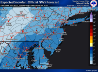
The NWS finally issued their first snowfall map that goes through the end of the storm and, as expected, they're generally in the 1-3" range with the lower amounts well NW of 95 (less precip) and the higher end of the range along and SE of 95, as well as SW towards Philly. Still some chance for 3-5" in some locations if some models are correct showing more precip/snow, but confidence is very high in at least 1-2" for everyone. NWS discussion highlighting the range of possibilities is below.

Area Forecast Discussion
National Weather Service Mount Holly NJ
231 PM EST Thu Dec 11 2025

The forecast gets more complicated for the Saturday night through
Sunday period as there will be several different things at play. In
the upper levels, there will be an upper level trough digging as it
moves from the Great Lakes region towards the east coast. Meanwhile
at the surface level, there will be an arctic front pushing into the
area from the NW as low pressure pivots through Quebec into northern
New England. Forecast guidance continues to indicate that a wave of
low pressure will form farther south near the front as it`s moving
through the mid Atlantic region Saturday night into Sunday morning.
However there are differences regarding the strength and track of
this system. The latest GFS continues to indicate that the low may
not really get going until it`s off the coast and if this were to
verify, most of the precip with the system would be near and south
of the I-95 corridor but mainly fall as snow. The NAM is at the
other end of the spectrum indicating a stronger low forming near
Delmarva. This would keep the heaviest precip with the system north
of the urban corridor with lighter amounts and more of a
snow/rain mix farther south. The 12z RGEM lies in between these
two extremes. There`s also a wide variation in the ensembles.
Given this continuing uncertainty, we largely stayed close to
the NBM. And the bottom line with this forecast is that we do
expect precip to move in either late Saturday evening or
overnight Saturday night. It should be mainly snow except near
the coast where some mixing with rain is likely...especially at
the onset. And if arrives early enough Saturday evening, some
rain or mixing could also occur near the urban corridor. The
bulk of the precip falls overnight Saturday night through the
first half of Sunday morning. This had been looking like a light
precip event but some of the latest guidance has also beefed up
QPF amounts into the .25 to .50 inch range. The big questions
though are where the highest amounts will fall and how this will
translate to snowfall. We admittedly still lean a little on the
conservative side with forecast snow amounts and continue to
indicate a fairly widespread 1-3 inches falling across the area.
There is the potential though that some areas could see snow
amounts in the 3 to 5 inch range given the general uptick in
forecast QPF. The big question though is where these amounts
occur. A more northern track would result in these higher
occuring over eastern PA into northern NJ where a more southern
track would favor higher amounts along the coastal plain. At
this point, the main thing to stress is this continuing
uncertainty in the details despite overall moderate confidence
in there being an accumulating snowfall event affecting the
area.

1765494721561.png
 

Knight Shift

Heisman
May 19, 2011
86,707
84,257
113
Yes there is - on the high side, as most forecasters are being conservative with 1-3" calls for most, but the potential for 3-5" is significantly greater than the potential for <1", as I discussed above.
Just for that, I'm going to add fuel to my snowblower, start it and have it ready by the garage door. That will keep the totals down. It has been 3 plus years since we have used the snowblower.
 

RU848789

Heisman
Jul 27, 2001
64,486
43,595
113
Just for that, I'm going to add fuel to my snowblower, start it and have it ready by the garage door. That will keep the totals down. It has been 3 plus years since we have used the snowblower.
What were you doing from 2000-2018, the golden age of NJ snowstorms? Many of the models have Monmouth Co. being in the bullseye, with your area getting 3-6".
 
  • Like
Reactions: Knight Shift

Knight Shift

Heisman
May 19, 2011
86,707
84,257
113
What were you doing from 2000-2018, the golden age of NJ snowstorms? Many of the models have Monmouth Co. being in the bullseye, with your area getting 3-6".
Have had the same snowblower for 20 years or so. Maybe it will get a long overdue workout. I appreciate your updates.
 

bac2therac

Hall of Famer
Jul 30, 2001
240,324
170,153
113
This just feels like a 2-3 inch event for much of Northern and Central Jersey with some dollops of 4 -5 in south jersey and toward the coast

All models at thus time are basically 2-4 except the GFS which is a coating to an inch
 
  • Like
Reactions: RU848789

Knight Shift

Heisman
May 19, 2011
86,707
84,257
113
Looks like up to 4" for at least 1/3 of the state in central and south Jersey. Fairly significant amount considering the past couple of winters. This will not stop the troublemakers and mean girls from honking bust if they get little in their locale.
 

RU848789

Heisman
Jul 27, 2001
64,486
43,595
113
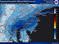
Sunday Snowfall: still looking like a 2-4" snowfall for most of the Philly-NJ-NYC area, as per the NWS map below, with areas well NW of 95 (NW Sussex/Warren, Poconos, NW Hudson Valley) likely only getting 1-2", due to less precip and SENJ (south of LBI) possibly only getting 1-2" due to some rain/mixing and along/near the 95 corridor and towards the coast looking most likely to get the 3-4" amounts.

Temps should be below 32F for the duration of the storm for most, which should start around 10-11 pm Saturday and be mostly over by 9-10 am Sunday, so every flake will accumulate and untreated roads/surfaces will be snow covered and slippery. After the storm, we head into the icebox with temps not going above freezing until Wednesday, but we may finally see our first 50s this December by Thursday.

We're still 40+ hours from the start of the storm, meaning there is still some uncertainty on the forecast, so it's possible the track moves SE and the 1-2" swath moves SE into the 95 corridor with <1" well NW of 95 or that the track moves NW and brings the 2-4" snows to the far NW areas, while bringing more rain/mix to the coast; there are 1-2 models showing less snow towards the NW and 1-2 showing less snow at the coast, but most are fairly well aligned with the NWS forecast. To illustrate the potential boundaries of the forecast, the NWS shows a 10% chance of only an inch or so for 95 and shows a 10% chance of 5-7" for 95.

chrome-extension://efaidnbmnnnibpcajpcglclefindmkaj/https://www.weather.gov/media/phi/current_briefing.pdf

https://www.weather.gov/phi

1765547229654.png
 
  • Like
Reactions: Postman_1

Knight Shift

Heisman
May 19, 2011
86,707
84,257
113
Sunday Snowfall: still looking like a 2-4" snowfall for most of the Philly-NJ-NYC area, as per the NWS map below, with areas well NW of 95 (NW Sussex/Warren, Poconos, NW Hudson Valley) likely only getting 1-2", due to less precip and SENJ (south of LBI) possibly only getting 1-2" due to some rain/mixing and along/near the 95 corridor and towards the coast looking most likely to get the 3-4" amounts.

Temps should be below 32F for the duration of the storm for most, which should start around 10-11 pm Saturday and be mostly over by 9-10 am Sunday, so every flake will accumulate and untreated roads/surfaces will be snow covered and slippery. After the storm, we head into the icebox with temps not going above freezing until Wednesday, but we may finally see our first 50s this December by Thursday.

We're still 40+ hours from the start of the storm, meaning there is still some uncertainty on the forecast, so it's possible the track moves SE and the 1-2" swath moves SE into the 95 corridor with <1" well NW of 95 or that the track moves NW and brings the 2-4" snows to the far NW areas, while bringing more rain/mix to the coast; there are 1-2 models showing less snow towards the NW and 1-2 showing less snow at the coast, but most are fairly well aligned with the NWS forecast. To illustrate the potential boundaries of the forecast, the NWS shows a 10% chance of only an inch or so for 95 and shows a 10% chance of 5-7" for 95.

chrome-extension://efaidnbmnnnibpcajpcglclefindmkaj/https://www.weather.gov/media/phi/current_briefing.pdf

https://www.weather.gov/phi

View attachment 1070000
Hoping coastal warming creeps further north as it often tends to do, cutting down the amounts in coastal Monmouth/Ocean County
 

MulletCork

All-Conference
Sep 1, 2012
2,634
3,156
113
At least it's finally supposed to warm up in the Wednesday / Thursday time frame, so whatever of this frozen piss that falls will be melted and gone in short order.
 

RU848789

Heisman
Jul 27, 2001
64,486
43,595
113
12z nam came in way less amped keeping higher totals in central and southern nj
NAM a decent amount less, but GFS a decent amount more (they're now similar to each other with 1-2" for 95 and NW of 95 but 2-4" SE of 95 to the coast, while the RGEM and RRFS (the new NAM soon, which is finally being replaced) still have a general 2-4" for just about everywhere except well NW. Will be interesting to see if the Euro/CMC remain in the 2-4" for most camp. Will see soon, but the Euro, in particular has been rock solid for a few days with only minor deviations.

Edit: CMC mostly the same, i.e., still in the 2-4" camp for most, Euro cut back a tad to 2-3" for most, UK remained the same (in the 1-3" for most range) and the AIFS bumped up a little, but is still 2-3" for most. I don't see much that would change the NWS forecast of 2-3" for most with 3-4" for some, especially along/SE of 95. I'd expect to see advisories go up at 4 pm for just about the entire area (probably not far NWNJ/Poconos and NW Hudson Valley).
 
Last edited:

RU848789

Heisman
Jul 27, 2001
64,486
43,595
113
I have tickets to the WhyHunger benefit concert at the Stone Pony Sunday night. Hopefully, the roads are clear by then.
Can't imagine any issues by then on any major/secondary roads, but some local roads could be slick in spots given the possibility of snow blowing back onto them with gusty winds later on Sunday.
 
  • Like
Reactions: LeapinLou

Knight Shift

Heisman
May 19, 2011
86,707
84,257
113
I have tickets to the WhyHunger benefit concert at the Stone Pony Sunday night. Hopefully, the roads are clear by then.
I'll pick you up in my pickup truck if you have an extra ticket. Any word on if HE will be there?

Hope the wind is whipping down the boardwalk.

 
  • Like
Reactions: BossNJ

RU848789

Heisman
Jul 27, 2001
64,486
43,595
113
NAM a decent amount less, but GFS a decent amount more (they're now similar to each other with 1-2" for 95 and NW of 95 but 2-4" SE of 95 to the coast, while the RGEM and RRFS (the new NAM soon, which is finally being replaced) still have a general 2-4" for just about everywhere except well NW. Will be interesting to see if the Euro/CMC remain in the 2-4" for most camp. Will see soon, but the Euro, in particular has been rock solid for a few days with only minor deviations.

Edit: CMC mostly the same, i.e., still in the 2-4" camp for most, Euro cut back a tad to 2-3" for most, UK remained the same (in the 1-3" for most range) and the AIFS bumped up a little, but is still 2-3" for most. I don't see much that would change the NWS forecast of 2-3" for most with 3-4" for some, especially along/SE of 95. I'd expect to see advisories go up at 4 pm for just about the entire area (probably not far NWNJ/Poconos and NW Hudson Valley).
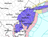
The NWS offices in Philly and NYC just issued advisories for 2-4" of snow late Saturday night through mid-morning on Sunday for every county in blue, below, i.e. SEPA (and northern DE/MD Eastern Shore), all of CNJ/SNJ, NENJ up to Hudson and all of NYC/LI. This means they're thinking there will be more precip along/SE of 95 (vs. NW of 95 and N of 78) and especially at the coast, such that even though it will likely start as a period of rain for the coast, they'll more than make up for that with more snow later in the storm (even for SENJ).

They didn't issue advisories for most of northern NJ (N of 78 mostly), the Lehigh Valley, the Poconos or the Hudson Valley, where <3" (the advisory criterion) is expected, although they are still forecasting a range of 1-3" for counties neighboring the blue counties to the west and north in PA/NJ/NY and 1-2" a little further inland than that to the west and the north. The snowfall map has not been updated, but I think it's going to be very similar to this morning's when it comes out in 2-3 hours. In the meantime, below is the NBM (National Blend of Models) map, which the NWS relies heavily upon and it hasn't changed much since this morning when it was very similar to the NWS map.

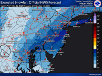
Edit: added in the new NWS snow map, reflecting the lower amounts to the W and N, where there are no advisories, but showing the jackpot swaths SE of 95 towards the coast in NJ and for E LI. And FWIW, I'm thinking 4" for my house, as I think this may overperform slightly for the 95 corridor, including Metuchen (NWS forecast is for 3.3").

https://www.weather.gov/phi

URGENT - WINTER WEATHER MESSAGE
National Weather Service Mount Holly NJ
137 PM EST Fri Dec 12 2025

New Castle-Kent-Kent MD-Queen Annes-Talbot-Caroline-Hunterdon-
Somerset-Middlesex-Western Monmouth-Eastern Monmouth-Mercer-Salem-
Gloucester-Camden-Northwestern Burlington-Ocean-Cumberland-
Atlantic-Cape May-Atlantic Coastal Cape May-Coastal Atlantic-
Coastal Ocean-Southeastern Burlington-Delaware-Philadelphia-
Western Chester-Eastern Chester-Western Montgomery-Eastern
Montgomery-Upper Bucks-Lower Bucks-
Including the cities of Sandy Hook, Pottstown, Media, West
Chester, Camden, Morrisville, Pennsville, Wharton State Forest,
Jackson, Easton, New Brunswick, Freehold, Somerville,
Collegeville, Dover, Cape May Court House, Mount Holly, Honey
Brook, Glassboro, Perkasie, Hammonton, Norristown, Moorestown,
Lansdale, Ocean City, Millville, Oxford, Kennett Square,
Chalfont, Denton, Atlantic City, Centreville, Cherry Hill,
Chestertown, Flemington, Trenton, Philadelphia, Long Beach
Island, Wilmington, and Doylestown
137 PM EST Fri Dec 12 2025

...WINTER WEATHER ADVISORY IN EFFECT FROM 7 PM SATURDAY TO 1 PM EST
SUNDAY...

* WHAT...Snow expected. Total snow accumulations between 2 and 4
inches.

* WHERE...Portions of central and northern Delaware, northeast
Maryland, central, northern, northwest, and southern New Jersey,
and southeast Pennsylvania.

* WHEN...From 7 PM Saturday to 1 PM EST Sunday.

* IMPACTS...Plan on slippery road conditions.


URGENT - WINTER WEATHER MESSAGE
National Weather Service New York NY
139 PM EST Fri Dec 12 2025

Hudson-Eastern Essex-Western Union-Eastern Union-New York
(Manhattan)-Bronx-Richmond (Staten Island)-Kings (Brooklyn)-
Northwest Suffolk-Northeast Suffolk-Southwest Suffolk-Southeast
Suffolk-Northern Queens-Northern Nassau-Southern Queens-Southern
Nassau-
139 PM EST Fri Dec 12 2025

...WINTER WEATHER ADVISORY IN EFFECT FROM 10 PM SATURDAY TO 1 PM EST
SUNDAY...

* WHAT...Snow expected. Total snow accumulations between 2 and 4
inches.

* WHERE...Portions of northeast New Jersey and southeast New York.

* WHEN...From 10 PM Saturday to 1 PM EST Sunday.

* IMPACTS...Roads, and especially bridges and overpasses, will
likely become slick and hazardous.


1765566884855.png

1765570416568.png

1765568016977.png
 
Last edited:
  • Wow
Reactions: LeapinLou