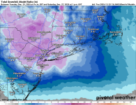
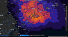
Been discussing this for a few days on the other thread and figured it's time for a separate thread given strong model consensus on a moderate (2-4" is my definition of moderate) snowfall and some models showing a significant snowfall of 4-7" (my definition of significant is 4-8"). There are always things that can go awry with a still-not-yet-even-formed storm 3+ days out, but this is about as good as it gets for the EPA-NJ-NYC-LI region with regard to model consensus, as 2-4" is shown by all the major global models (Euro, AIFS, GFS, CMC, and UK at least) with the AIFS (the Euro AI model) and the GFS (and the others in spots) showing widespread 4-7" amounts; the GFS, by the way, has led the way on this one, consistently showing a sizable snowstorm for a couple of days, so it could pull a modeling coup if it ends up being close to right (after crapping the bed on the 12/14 storm, but doing pretty well with today's event).
At this point the energy for this future storm is still over the Pacific and poorly sampled, so model uncertainty is still appreciable (uncertainty on initial conditions propagates and increases for model outputs with time) and it's always possible we see more of a snow to sleet to rain event, especially for 95 and the coast (and especially south of 276/195), as we see on the CMC model up through Philly and SNJ keeping accumulations way down and that possibly even moves futher north into CNJ, but that's only 1 of 5 models showing that. The CMC scenario results from the upper level shortwave approaching from the Ohio Valley, eventually, taking a more northern track to the DelMarVa, where surface cyclogenesis is likely to fuel the storm (not too different from 12/14) bringing warm air further north. The other possibility is that the track is further south than the NC/VA border, leading to less precip/snow for CNJ and northward and more towards Philly/SNJ/Balt. Plenty of time to sort all of this out, but having a decent consensus close to 3 days out is fairly unusual. Here's what the NWS said this morning and below is a link to the AmericanWx thread for those who want to see all the model maps.
Finally, it's been fascinating to watch this system evolve, as there were individual model runs 8-10 days out showing a significant snowstorm, but the models all were showing warmth and rain from then until Sunday night when we started seeing models showing a colder, snowier solution. If anyone wants to see a deep diver into what, exactly, happened meteorologically to drive that big change in modeled outcomes take a look at the Twitter thread from meteorologist Tomer Burg, below.
https://forecast.weather.gov/produc...&format=CI&version=1&glossary=1&highlight=off
https://www.americanwx.com/bb/topic/62460-snow-potential-dec-26-27/page/5/
Area Forecast Discussion
National Weather Service Mount Holly NJ
1222 PM EST Tue Dec 23 2025
It appears that a shortwave embedded within northwesterly flow
aloft will pass through the area Friday afternoon into Saturday
morning. At the surface, low pressure looks to track out of the
Ohio Valley and towards our region, with additional surface
cyclogenesis possible somewhere off the Eastern Seaboard Friday
night. There remains significant spread amongst GEFS and EPS
members in where this will occur, ranging from just east of
North Carolina to east of the New Jersey coastline. Where this
occurs will depend in large part on a strong area of high
pressure centered over Quebec, and how quickly it retreats
northeastward. Latest trends have been favoring a stronger high,
and therefore low placement farther south. Widespread
precipitation is expected across our area with this system, and
with the trends towards a stronger and slower retreating high,
the forecast has also continued to trend colder. It is too soon
and model spread remains too high to speculate on specifics, but
the odds of impactful wintry precipitation are increasing.


