Bigger thanks to the other poster that started the first thread on this storm.Yes, thanks to numbers and you for providing a heads up. Appreciated.
OT: Significant snowstorm on Friday night into Saturday
- Thread starter Mikemarc
- Start date
You are using an out of date browser. It may not display this or other websites correctly.
You should upgrade or use an alternative browser.
You should upgrade or use an alternative browser.
Those throwing those amounts are now are irresponsible including the dog who needs a time out
And already a thread on this:

OT: Significant snowstorm on Friday night into Saturday - Forums
A light dusting to a few inches possible tonight and tomorrow it seems - not a big deal at all. Friday - models are showing a larger storm that may be a bit more significant. Our weather folks - is this accurate? I know alot of people traveling this week so figured I’d ask. Thanks!www.on3.com
Lee Goldberg predicted. 3-6 for our area and he’s usually pretty accurate.A sleetfest is very possible. Throwing out those amounts too early. More uncertainty with this system than you are letting on
Yes. And that became a big problem with the Boxing Day storm of 2010, although this doesn’t look like nearly as big a deal as that one.One thing that is likely to happen people wont be focused too much on the event because not a lot of hype until maybe tonight. With focus on X Mas peeps are distracted but should get their ducks in a row if they have major traveling to do on Friday
Will this be the usual anything south of Princeton gets mostly rain? Living in Mercer this always seems to be the case.
We like our rain in the Greater P-Ton area.Will this be the usual anything south of Princeton gets mostly rain? Living in Mercer this always seems to be the case.
Why would you merge threads? We have 33 threads on dead people, but we can't have 2 threads on an impactful storm? I had been enjoying a weather thread without trolls for awhile. Do us all a favor and thread ban the king of the dipshits, Troll2K - the weather threads were so much better when @DJ Spanky used to thread-ban him. Otherwise these threads always get derailed and the silent majority finds that annoying.
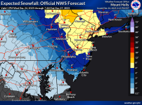
NWS just updated their discussion, which is similar to what I posted above; the one thing they mention that I didn't was that there is a decent chance some folks will get some freezing rain - where and when that is is hard to know, but interior locations usually get that more often. The NWS will likely issue their first snowfall map at 4 am tomorrow (they issue 72-hr maps), but until then, the NBM (model blend) is worth looking at to see what the NWS is looking at (they use the NBM a lot) - note that 1-2" of the snow north of about 80 is snow that is falling today, since it's total projected snow from this morning at 8 am through 1 pm Saturday.
View attachment 1090597
Area Forecast Discussion
National Weather Service Mount Holly NJ
226 PM EST Tue Dec 23 2025
.LONG TERM /FRIDAY THROUGH MONDAY/...
An active and unsettled period is ahead for the weekend and
potentially into next week. Main period to watch will be Friday and
Friday Night as well as Sunday and Sunday Night as two systems
impact the region, likely bringing some form of wintry weather.
The first system comes in Friday into Friday Night. There is a
lot of uncertainty with this system as high pressure off the
north will result in some cold air in place, but warm air aloft
will be trying to erode that cold air. There likely will be a
transition zone setting up over our area between all rain,
sleet/freezing rain, and snow. The track and timing of the
surface low will make all the difference, and hopefully that
will come into focus over the next few forecast cycles. The
trend as of late has been a bit slower and further south with
the track of the surface low, which would actually result in
more impacts for our region. The potential is certainly there
for accumulating snow, possibly significant, for areas north of
Philadelphia. A wide variety of outcomes exist still among
deterministic guidance, with the GFS bringing significant
accumulations from Philadelphia on north, the GEM having minor
snowfall limited to northern areas, and the ECWMF and its AI
counterpart going more in the middle of those solutions. NBM
Probability of 2" or more of snow is around 50-80% from Philly
on north with probabilities decreasing drastically the further
south you go. Probability of 6" or more of snow is around 15-30%
for the Philly metro, Lehigh Valley, and Poconos, with around a
40-50% chance for North Jersey.
Another component with this storm is the potential for some freezing
rain and measurable ice accumulation. Again, still too early to know
for sure given low confidence, but current probabilistic
guidance from the NBM has around a 30-50% chance of ice
accumulations greater than a tenth of an inch from the I-95
corridor on west.
This evening's 18Z (1 pm data inputs) and 0Z (7 pm data inputs) models continue to show pretty good consensus on a plowable snowfall Friday night into Saturday with most forecasters predicting 2-4/3-6" for most of the Philly-NJ-NYC region, although there are still questions and uncertainty on things like where will there be mixing or changeovers to sleet/rain and maybe freezing rain (more likely towards Philly/SNJ, where it could be a sleetfest - even up into CNJ), who gets all snow (more likely from 78 north) and will there be a sharp precip cutoff somewhere?
Bottom line is that an impactful storm is shaping up, which will very likely make travel difficult. In addition, it should be noted that some models are showing more than 6" for most of the area, so there so a bit more than forecasters are predicting is possible if things play out "right," although nobody is predicting anything close to the Boxing Day Blizzard of 2010), when most of the region got 18-30" of snow. I remember that one quite vividly.
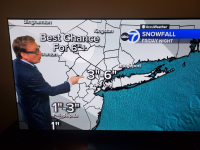
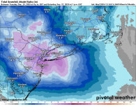
Below is Lee Goldberg's preliminary map with 3-6" for most and 1-3" south of a Bordentown to Barnegat line, which I think is a good preliminary call, and the NBM (National Model Blend which shows the average of most of the models forecasters use (this one is on the high side, but the NWS uses the NBM a fair amount). Note that the NWS put out a map through 7 pm Friday showing 1-2" for most, meaning the Friday evening commute could be a bit snowy with more to come through the nighttime (they only go out 72 hours in their snowfall forecasts, but have discussed 3-6" total amounts for most and I don't like posting partial maps, which can be confusing). Long way to go, so we'll likely see the usual model shifts and gnashing of teeth.
https://www.weather.gov/phi
Since I'm no longer the thread originator, could you update the thread title, since this is likely to be a pretty impactful winter storm? Maybe something like moderate to significant winter storm likely Friday night into Saturday morning. Thanks.A light dusting to a few inches possible tonight and tomorrow it seems - not a big deal at all.
Friday - models are showing a larger storm that may be a bit more significant.
Our weather folks - is this accurate? I know alot of people traveling this week so figured I’d ask. Thanks!
A bit on the cold side, but most will still melt by next week, unless we get more (outside shot)What’s the weather look like after the storm?
Leaving tomorrow for in-laws until next week.
Will all this be melted by the time we get back?
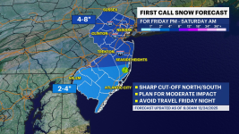
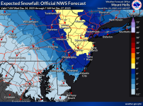
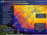
Impactful storm on its way, with plenty of frozen precip, but precip type is still in question for many. First NWS snowfall map for the Friday late afternoon into Saturday morning event, below, looks a lot like the NBM map from last night, which is no surprise given the NWS uses that tool heavily in its forecasts as per the discussion below. Bottom line is it's just about a lock to have significant frozen precip for most of the Philly-NJ-NYC region, but there is significant uncertainty on precip type over time, especially closer to the low pressure system passing by to our SW and then S, as those areas will likely have significant sleet and possibly even freezing rain, i.e., SW of about an Allentown to LBI line. For areas N/E of that line all snow would bring 5-7" (the area in yellow). However, remember while sleet depth is about 1/3 that of 10:1 ratio snow, the frozen mass and impact on roads and removal is the same (it's just not as pretty and has no visibility issues), so areas that get 1-2" of snow and 1-2" of sleet (2-4" total) are getting the equivalnet of 4-8" of 10:1 ratio snow. Snow amounts also are predicted to drop off a bit NE towards NYC/LI/CT/SENY, due to a bit less precip,but those areas are predicted to be all snow. The 2nd map shows more detail on the NWS expected precip types.
Very complex forecast, obviously, and since we're still ~60 hours from the start of the event, some significant changes are still possible, which could mean more snow to the SW of that Allentown to LBI line if the storm track stays further south of our area, but could also mean more sleet/less snow NE of that line if the track goes further N than forecast. The main issue is that temps well aloft and at the surface will be cold enough for snow almost everywhere, but at mid-levels of the atmosphere (from 700-850 mbar several thousand feet up), an above 32F layer is likely for areas that get sleet (if the cold layer below 32F near the surface is deep enough to refreeze the melted snow that is falling) or freezing rain (if the cold layer below 32F near the surface is shallow). Note that the latest 6Z models show more sleet and freezing rain than last night's models for the area in yellow, especially after about 1 am Saturday, i.e., much of the accumulating snow will likely come with a thump from 5 pm to 11 pm with a transition to sleet/freezing rain for many after that. Personally, I think much of the area in yellow, including most of CNJ, except near 78, is likely to get maybe 2-4" of front end snow, followed by an inch or so of sleet vs. 5-7" of all snow - many mets on-line are saying the same. We'll see.
https://forecast.weather.gov/produc...&format=CI&version=1&glossary=1&highlight=off
Area Forecast Discussion
National Weather Service Mount Holly NJ
419 AM EST Wed Dec 24 2025
For the Friday through Friday night winter storm: Bottom line
up front - We are near 100% confident that most of our area will
receive wintry precipitation of some variety, save for our
southern Delmarva zones. The biggest question marks remains the
QPF and precipitation type forecast. Thus, the exact amount of
snow, sleet, and ice that any given location will receive
remains uncertain at this time. Folks with travel plans from
Friday afternoon through Friday night should expect impacts to
their plans, as road conditions will likely deteriorate during
this time with snowy and/or icy roads. Meteorological forecast
details follow below.
An unusual and thus very challenging meteorological forecast
setup for the Friday through Friday night winter storm. A polar
jet ridge will be building into eastern Canada, which will
provide low level cold, dry air from Canadian high pressure
needed for wintry precipitation in our region. Meanwhile, a
subtropical trough will attempt to amplify as it slides just to
our southwest Friday night. This will push a low pressure system
from the lower Great Lakes and upper Ohio Valley region Friday
across the Appalachians Friday night and offshore of the Mid
Atlantic coast by Saturday morning. This setup will result in
widespread precipitation for our region (near 100% chance).
Temperatures will likely be near to well below freezing across
the area Friday night, which will support accumulating wintry
precipitation.
A warm nose around 750 mb will push eastward into the area from
the west as precipitation spreads into the region around midday
Friday or Friday afternoon, with its 0C+ temperatures reaching
as far east as the Lehigh Valley, Philly metro, and southern New
Jersey. East of this line (northern and central NJ),
precipitation will likely remain all or mostly all snow. Near
and west of this line may experience some snow initially on
Friday before changing to sleet, or perhaps some freezing rain
or plain rain depending on surface temperatures and timing. For
precipitation type along and west of this line, it appears sleet
will be most favorable for much of the event, as the melting
layer will be quite high in the atmosphere and have plenty of
well below freezing air and time to refreeze into sleet before
reaching the ground. Some freezing rain is certainly possible
for far western areas in the CWA (SE PA, Philly proper, northern
Delmarva), especially later in the event when low level
temperatures (850-925 mb) warm closer to or above freezing.
As for our current deterministic forecast totals, we stuck
closely with the NBM as uncertainty remains very high on the
exact amounts. QPF amounts range from around 0.5-0.75" in most
areas. Snowfall totals range from 1-3" in northern Delmarva, far
southern NJ, and SE PA to 4-7" in eastern PA and much of NJ.
These totals could end up lower in the transition zone (where
ever that ends up) and areas that experience mostly sleet. It`s
possible some areas get 1-2"+ of pure sleet. Ice amounts are as
much as 0.1-0.25" in portions of SE PA, but these could be too
high if mostly sleet occurs.
Probabilistic amounts likely paint a better picture at this
stage in the forecast. The chance of plowable snow/sleet (2" or
more) is around 50-70% for northern DE, far southern NJ, and
west of I-476 in PA. Elsewhere to the north and east (where
precip is likely all snow), probabilities increase substantially
to around 70-90%. The probability of 5" or more is around
60-70% from Burlington County and north in NJ and adjacent
counties in PA, then drop off precipitously as you go west and
south from there. The probability of 0.10" of ice or more is
around 30-60% in SE PA and northern DE.
So to make this long AFD short, there is nearly a 100% chance
of wintry precipitation that will likely cause travel issues
beginning during the day Friday through Friday night, and
potentially lingering into Saturday morning. A Winter Storm
Watch was considered with this update, but the probability of
warning level snow is not large enough in coverage at this point
for one. Watches may need to be considered in future updates
though.
Very complex forecast, obviously, and since we're still ~60 hours from the start of the event, some significant changes are still possible, which could mean more snow to the SW of that Allentown to LBI line if the storm track stays further south of our area, but could also mean more sleet/less snow NE of that line if the track goes further N than forecast. The main issue is that temps well aloft and at the surface will be cold enough for snow almost everywhere, but at mid-levels of the atmosphere (from 700-850 mbar several thousand feet up), an above 32F layer is likely for areas that get sleet (if the cold layer below 32F near the surface is deep enough to refreeze the melted snow that is falling) or freezing rain (if the cold layer below 32F near the surface is shallow). Note that the latest 6Z models show more sleet and freezing rain than last night's models for the area in yellow, especially after about 1 am Saturday, i.e., much of the accumulating snow will likely come with a thump from 5 pm to 11 pm with a transition to sleet/freezing rain for many after that. Personally, I think much of the area in yellow, including most of CNJ, except near 78, is likely to get maybe 2-4" of front end snow, followed by an inch or so of sleet vs. 5-7" of all snow - many mets on-line are saying the same. We'll see.
https://forecast.weather.gov/produc...&format=CI&version=1&glossary=1&highlight=off


Area Forecast Discussion
National Weather Service Mount Holly NJ
419 AM EST Wed Dec 24 2025
For the Friday through Friday night winter storm: Bottom line
up front - We are near 100% confident that most of our area will
receive wintry precipitation of some variety, save for our
southern Delmarva zones. The biggest question marks remains the
QPF and precipitation type forecast. Thus, the exact amount of
snow, sleet, and ice that any given location will receive
remains uncertain at this time. Folks with travel plans from
Friday afternoon through Friday night should expect impacts to
their plans, as road conditions will likely deteriorate during
this time with snowy and/or icy roads. Meteorological forecast
details follow below.
An unusual and thus very challenging meteorological forecast
setup for the Friday through Friday night winter storm. A polar
jet ridge will be building into eastern Canada, which will
provide low level cold, dry air from Canadian high pressure
needed for wintry precipitation in our region. Meanwhile, a
subtropical trough will attempt to amplify as it slides just to
our southwest Friday night. This will push a low pressure system
from the lower Great Lakes and upper Ohio Valley region Friday
across the Appalachians Friday night and offshore of the Mid
Atlantic coast by Saturday morning. This setup will result in
widespread precipitation for our region (near 100% chance).
Temperatures will likely be near to well below freezing across
the area Friday night, which will support accumulating wintry
precipitation.
A warm nose around 750 mb will push eastward into the area from
the west as precipitation spreads into the region around midday
Friday or Friday afternoon, with its 0C+ temperatures reaching
as far east as the Lehigh Valley, Philly metro, and southern New
Jersey. East of this line (northern and central NJ),
precipitation will likely remain all or mostly all snow. Near
and west of this line may experience some snow initially on
Friday before changing to sleet, or perhaps some freezing rain
or plain rain depending on surface temperatures and timing. For
precipitation type along and west of this line, it appears sleet
will be most favorable for much of the event, as the melting
layer will be quite high in the atmosphere and have plenty of
well below freezing air and time to refreeze into sleet before
reaching the ground. Some freezing rain is certainly possible
for far western areas in the CWA (SE PA, Philly proper, northern
Delmarva), especially later in the event when low level
temperatures (850-925 mb) warm closer to or above freezing.
As for our current deterministic forecast totals, we stuck
closely with the NBM as uncertainty remains very high on the
exact amounts. QPF amounts range from around 0.5-0.75" in most
areas. Snowfall totals range from 1-3" in northern Delmarva, far
southern NJ, and SE PA to 4-7" in eastern PA and much of NJ.
These totals could end up lower in the transition zone (where
ever that ends up) and areas that experience mostly sleet. It`s
possible some areas get 1-2"+ of pure sleet. Ice amounts are as
much as 0.1-0.25" in portions of SE PA, but these could be too
high if mostly sleet occurs.
Probabilistic amounts likely paint a better picture at this
stage in the forecast. The chance of plowable snow/sleet (2" or
more) is around 50-70% for northern DE, far southern NJ, and
west of I-476 in PA. Elsewhere to the north and east (where
precip is likely all snow), probabilities increase substantially
to around 70-90%. The probability of 5" or more is around
60-70% from Burlington County and north in NJ and adjacent
counties in PA, then drop off precipitously as you go west and
south from there. The probability of 0.10" of ice or more is
around 30-60% in SE PA and northern DE.
So to make this long AFD short, there is nearly a 100% chance
of wintry precipitation that will likely cause travel issues
beginning during the day Friday through Friday night, and
potentially lingering into Saturday morning. A Winter Storm
Watch was considered with this update, but the probability of
warning level snow is not large enough in coverage at this point
for one. Watches may need to be considered in future updates
though.
Last edited:
Lol, that usually seems to be the cutoff line. Storms always seem to shift North and West within 36 hours of hitting the Mercer area. You will probably get your wishWe like our rain in the Greater P-Ton area.
Lol, that usually seems to be the cutoff line. Storms always seem to shift North and West within 36 hours of hitting the Mercer area. You will probably get your wish
This one is different, in that the sleet/snow line is oriented more NW to SE as per the NWS map due to the angle of approach of the precip and the upper level low bringing the warmer air in aloft.
Merry Christmas my elderly friend. Enjoy the storm.Why would you merge threads? We have 33 threads on dead people, but we can't have 2 threads on an impactful storm? I had been enjoying a weather thread without trolls for awhile. Do us all a favor and thread ban the king of the dipshits, Troll2K - the weather threads were so much better when @DJ Spanky used to thread-ban him. Otherwise these threads always get derailed and the silent majority finds that annoying.
Some of those maps fly in the face of the latest NWS forecast for South Monmouth . I know you said he uncertainty is high, but so are the forecasted temps.Some other media sources below, plus Channel 7/AccuWeather has not changed their forecast from last night, in the post above.
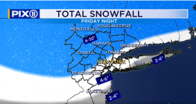
Mike Masco, Channel 11:
View attachment 1091636
News12NJ (Mike Rizzo):
View attachment 1091641
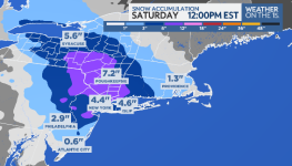
John Davitt:
View attachment 1091677
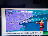
TWC:
View attachment 1091687
Friday Night
A 30 percent chance of showers, mainly after 11pm. Mostly cloudy, with a low around 42. South wind around 11 mph, with gusts as high as 18 mph.
Saturday
Showers likely, mainly after 11am. Mostly cloudy, with a high near 53. Southwest wind around 9 mph. Chance of precipitation is 60%.
Last edited:
I dont like the ICON model in general and usually it loves to put out highest amounts so even as its been the one model consistently showing the lowest amounts I will tossNot a good map for snow lovers if your in Central Jersey.
.png.3ac382851d6bd70cbb37950d1f828e53.png)
Type of frozen is definitely going to ve an issue with this storm. Mt Holly was quite bullish for central jersey but i dont see them changing much even as there is huge uncertainty with what area gets that sweetspot
Not a good map for snow lovers if your in Central Jersey.
.png.3ac382851d6bd70cbb37950d1f828e53.png)

The placement of sweet spot is going to be a huge difference between 2-4 and 5-8 and the models are all over the place at this time
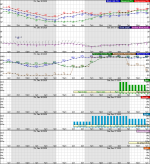
That's just wrong - is it possible you're looking at an old (cached?) version? Here's your point-and-click for Spring Lake, which is about as far south in S Monmouth you can get - 6.8" of snow.Some of those maps fly in the face of the latest NWS forecast for South Monmouth . I know you said he uncertainty is high, but so are the forecasted temps.
Friday Night
A 30 percent chance of showers, mainly after 11pm. Mostly cloudy, with a low around 42. South wind around 11 mph, with gusts as high as 18 mph.
Saturday
Showers likely, mainly after 11am. Mostly cloudy, with a high near 53. Southwest wind around 9 mph. Chance of precipitation is 60%.

Attachments
NJ 101.5 Dan Zarrows write up on it

 nj1015.com

Post-Christmas winter storm could bring heavy snow and ice to NJ
Christmas Eve will be bright and breezy. Christmas Day might feature some showers. On Friday, significant snowy and icy conditions are possible in New Jersey.
That's funny. The "detailed forecast" on my browser for Allenwood just became slightly more optimistic for snow, but the graphic is different. Have no idea what that is the case:That's just wrong - is it possible you're looking at an old (cached?) version? Here's your point-and-click for Spring Lake, which is about as far south in S Monmouth you can get - 6.8" of snow.
View attachment 1091912
View attachment 1091913
Friday
A chance of snow after 1pm. Mostly cloudy, with a high near 35. North wind around 5 mph becoming east in the afternoon. Chance of precipitation is 50%. New snow accumulation of less than one inch possible.
Friday Night
Snow before 1am, then rain and snow. Low around 26. Chance of precipitation is 100%. New precipitation amounts between a half and three quarters of an inch possible.
Mt Holly has hoisted Winter Storm Watches
URGENT - WINTER WEATHER MESSAGE
National Weather Service Mount Holly NJ
111 PM EST Wed Dec 24 2025
NJZ001-007>010-012>015-PAZ055-250900-
/O.NEW.KPHI.WS.A.0006.251226T1800Z-251227T1500Z/
Sussex-Warren-Morris-Hunterdon-Somerset-Middlesex-Western
Monmouth-Eastern Monmouth-Mercer-Monroe-
Including the cities of Freehold, Flemington, Newton, Sandy Hook,
Trenton, Somerville, Morristown, New Brunswick, Stroudsburg, and
Washington
111 PM EST Wed Dec 24 2025
...WINTER STORM WATCH IN EFFECT FROM FRIDAY AFTERNOON THROUGH
SATURDAY MORNING...
* WHAT...Heavy snow possible. Total snow accumulations between 5 and
8 inches possible.
* WHERE...Portions of central, northern, and northwest New Jersey
and northeast Pennsylvania.
* WHEN...From Friday afternoon through Saturday morning.
* IMPACTS...Travel could be very difficult. The hazardous conditions
could impact the Friday evening commute.
Winter storm watches up for most of the region (counties in grey). Map isn't updated yet, but the NBM (model blend) bumped up for most and moved the snow field a bit SW countering the move this morning (see below), so forecast is gaining in confidence, but still some uncertainty in how far north/northeast the warm air aloft makes it, turning snow to sleet for some of the storm (outright plain rain is looking unlikely for any part of CNJ). Watches are up for the following areas for the snow/sleet and ice amounts listed with some comments from looking at the point/click forecasts which are not explicitly listed in the watches.

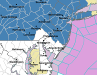
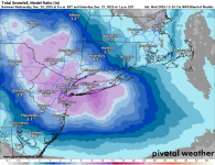
- For 4-6" for Camden, Coastal Ocean, Northwestern Burlington, Ocean, and Southeastern Burlington Counties; for this area, the NWS is expecting some of that to be sleet, which could keep accumulation depth down
- For 4-6" and up to 0.2" ice glaze for Carbon-Berks-Lehigh-Northampton-Philadelphia-Western Montgomery-Eastern Montgomery-Upper Bucks-Lower Bucks Counties; obviously the NWS feels there's more chance of sleet and then freezing rain here
- For 5-8" for Sussex-Warren-Morris-Hunterdon-Somerset-Middlesex-WesternMonmouth-Eastern Monmouth-Mercer-Monroe; NWS is basically calling for all snow for these counties
- For areas SW of the Philly/Camden/Burlco counties, the NWS-Philly is still predicting a few inches of snow, then sleet, then rain as those areas will be closer to the warmer air aloft from the storm; these areas will likely get advisories tomorrow.
- For 4-8" for almost the entire NWS-NYC area, i.e., Northern Fairfield-Southern Fairfield-Western Passaic-Eastern Passaic-Hudson-Western Bergen-Eastern Bergen-Western Essex-Eastern Essex-Western Union-Eastern Union-Orange-Putnam-Rockland-Northern Westchester-Southern Westchester-New York (Manhattan)-Bronx-Richmond (Staten Island)-Kings (Brooklyn)-Northwest Suffolk-Southwest Suffolk-Northern Queens-Northern Nassau-Southern Queens-Southern Nassau; the only exception is eastern Suffolk, where they expect a bit less snow than further west.
- All of the watches are in this link: https://forecast.weather.gov/wwamap/wwatxtget.php?cwa=PHI&wwa=winter storm watch


Last edited:
Don't see any gray on any NJ counties on the map you posted?Winter storm watches up for most of the region (counties in grey). Map isn't updated yet, but the NBM (model blend) bumped up for most and moved the snow field a bit SW countering the move this morning (see below), so forecast is gaining in confidence, but still some uncertainty in how far north/northeast the warm air aloft makes it, turning snow to sleet for some of the storm (outright plain rain is looking unlikely for any part of CNJ). Watches are up for the following areas for the snow/sleet and ice amounts listed with some comments from looking at the point/click forecasts which are not explicitly listed in the watches.
- For 4-6" for Camden, Coastal Ocean, Northwestern Burlington, Ocean, and Southeastern Burlington Counties; for this area, the NWS is expecting some of that to be sleet, which could keep accumulation depth down
- For 4-6" and up to 0.2" ice glaze for Carbon-Berks-Lehigh-Northampton-Philadelphia-Western Montgomery-Eastern Montgomery-Upper Bucks-Lower Bucks Counties; obviously the NWS feels there's more chance of sleet and then freezing rain here
- For 5-8" for Sussex-Warren-Morris-Hunterdon-Somerset-Middlesex-WesternMonmouth-Eastern Monmouth-Mercer-Monroe; NWS is basically calling for all snow for these counties
- For areas SW of the Philly/Camden/Burlco counties, the NWS-Philly is still predicting a few inches of snow, then sleet, then rain as those areas will be closer to the warmer air aloft from the storm; these areas will likely get advisories tomorrow.
- For 4-8" for almost the entire NWS-NYC area, i.e., Northern Fairfield-Southern Fairfield-Western Passaic-Eastern Passaic-Hudson-Western Bergen-Eastern Bergen-Western Essex-Eastern Essex-Western Union-Eastern Union-Orange-Putnam-Rockland-Northern Westchester-Southern Westchester-New York (Manhattan)-Bronx-Richmond (Staten Island)-Kings (Brooklyn)-Northwest Suffolk-Southwest Suffolk-Northern Queens-Northern Nassau-Southern Queens-Southern Nassau; the only exception is eastern Suffolk, where they expect sleet to keep accumulations down.
- All of the watches are in this link: https://forecast.weather.gov/wwamap/wwatxtget.php?cwa=PHI&wwa=winter storm watch
View attachment 1092062
View attachment 1092083

Here are predicted inch counts for towns in Monmouth County:
- Allentown: 1 to 3 inches
- Asbury Park: 3 to 6 inches
- Belmar: 2 to 4 inches
- Eatontown: 3 to 6 inches
- Freehold: 3 to 6 inches
- Highlands: 3 to 6 inches
- Keyport: 3 to 6 inches
- Long Branch: 3 to 6 inches
- Manalapan: 3 to 6 inches
- Manasquan: 2 to 4 inches
- Red Bank: 1 to 3 inches
- Shrewsbury: 1 to 3 inches
- Tinton Falls: 3 to 6 inches
- Union Beach: 3 to 6 inches
- Barnegat Light: coating to 1 inch
- Beach Haven: rain only
- Harvey Cedars: coating to 1 inch
- Jackson: 1 to 3 inches
- Lacey: coating to 1 inch
- Lakewood: 2 to 4 inches
- Little Egg Harbor: coating to 1 inch
- Manchester: some ice
- Point Pleasant: 2 to 4 inches
- Seaside Heights: coating to 1 inch
- Ship Bottom: coating to 1 inch
- Toms River: 2 to 4 inches
- Tuckerton: coating to 1 inch
Snow forecast: Predicted town totals for Monmouth, Ocean counties
Check the latest snow forecast for Monmouth and Ocean counties. Accumulating snow is expected to begin around 1 p.m. Friday.
www.app.com
Are you looking to earn a troll hat with that comment? Sorry, blue-grey, lol.Don't see any gray on any NJ counties on the map you posted?
No troll hat. Was looking for gray. Still trying to figure out the disconnect on NWS text forecast for "Allenwood, NJ" showing little to no snow and the graphical forecast showing a fair amount. I just checked and Allenwood now says 3-7" on the text forecast.Are you looking to earn a troll hat with that comment? Sorry, blue-grey, lol.
We are flying in from Phoenix Saturday night late, and hope all is cleared up by then.
