You know better.........still in its long range..........even though the Nam does a solid job sniffing out WAA events, I wouldn't put a ton of stock into it till 6z tomorrow run.18z NAM says hold everything lol
OT: Significant snowstorm on Friday night into Saturday
- Thread starter Mikemarc
- Start date
You are using an out of date browser. It may not display this or other websites correctly.
You should upgrade or use an alternative browser.
You should upgrade or use an alternative browser.

Still looks like it's creeping away from the Trenton/Mercer area? We are about 60 hours away. Hopefully we get more of an answer tomorrow.Winter storm watches up for most of the region (counties in grey). Map isn't updated yet, but the NBM (model blend) bumped up for most and moved the snow field a bit SW countering the move this morning (see below), so forecast is gaining in confidence, but still some uncertainty in how far north/northeast the warm air aloft makes it, turning snow to sleet for some of the storm (outright plain rain is looking unlikely for any part of CNJ). Watches are up for the following areas for the snow/sleet and ice amounts listed with some comments from looking at the point/click forecasts which are not explicitly listed in the watches.
Edit: NWS snowfall map is out now...
- For 4-6" for Camden, Coastal Ocean, Northwestern Burlington, Ocean, and Southeastern Burlington Counties; for this area, the NWS is expecting some of that to be sleet, which could keep accumulation depth down
- For 4-6" and up to 0.2" ice glaze for Carbon-Berks-Lehigh-Northampton-Philadelphia-Western Montgomery-Eastern Montgomery-Upper Bucks-Lower Bucks Counties; obviously the NWS feels there's more chance of sleet and then freezing rain here
- For 5-8" for Sussex-Warren-Morris-Hunterdon-Somerset-Middlesex-WesternMonmouth-Eastern Monmouth-Mercer-Monroe; NWS is basically calling for all snow for these counties
- For areas SW of the Philly/Camden/Burlco counties, the NWS-Philly is still predicting a few inches of snow, then sleet, then rain as those areas will be closer to the warmer air aloft from the storm; these areas will likely get advisories tomorrow.
- For 4-8" for almost the entire NWS-NYC area, i.e., Northern Fairfield-Southern Fairfield-Western Passaic-Eastern Passaic-Hudson-Western Bergen-Eastern Bergen-Western Essex-Eastern Essex-Western Union-Eastern Union-Orange-Putnam-Rockland-Northern Westchester-Southern Westchester-New York (Manhattan)-Bronx-Richmond (Staten Island)-Kings (Brooklyn)-Northwest Suffolk-Southwest Suffolk-Northern Queens-Northern Nassau-Southern Queens-Southern Nassau; the only exception is eastern Suffolk, where they expect a bit less snow than further west.
- All of the watches are in this link: https://forecast.weather.gov/wwamap/wwatxtget.php?cwa=PHI&wwa=winter storm watch
View attachment 1092107
View attachment 1092062
View attachment 1092083
View attachment 1092108
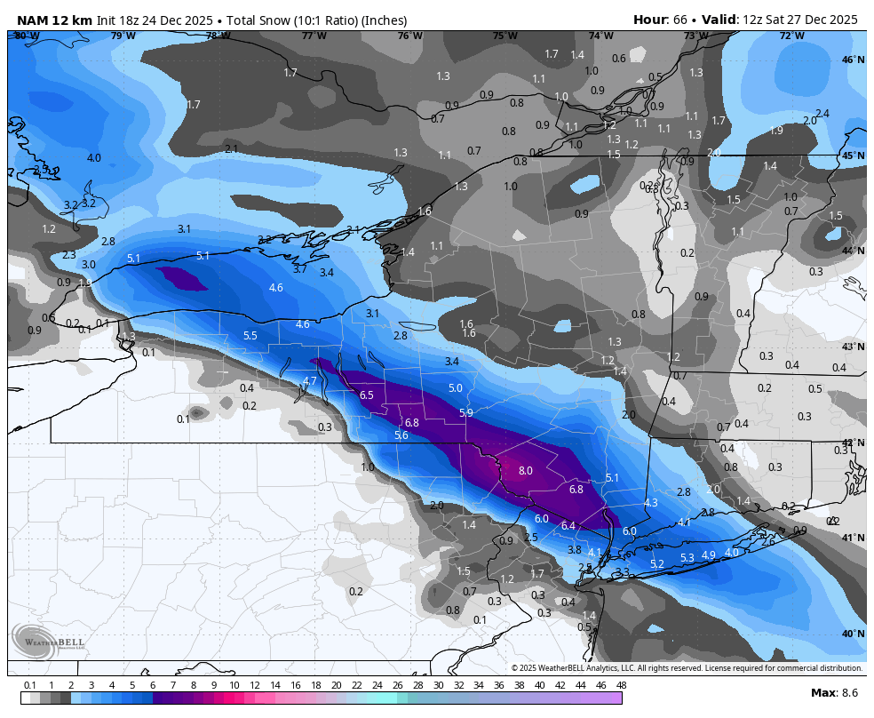
Sorry, but pasting 12km NAM solutions way out of its range simply isn't helpful, especially when the related 3km NAM shows snow only SE of Trenton, which makes zero sense. The globals/ensembles are still the way to go 54 hours out and they're still showing similar outcomea at 18Z, so far. The NAM has sniffed out warm noses before, but not usually this far out - and note that that graphic doesn't include sleet - most of the area down to Philly to LBI still gets 4-6" of "snow" as sleet, i.e., 1-2" sleet on top of maybe 1" or snow Tropical Tidbits shows the sleet as snow.Oof got NAM'ddd

You know better.........still in its long range..........even though the Nam does a solid job sniffing out WAA events, I wouldn't put a ton of stock into it till 6z tomorrow run.
Just one more solution...some support from the euro which has lesser amounts for CJ
Rgem edging closer to that nam run...just domething to watch
In these models as well as the Euro..highest amounts are North Jersey and ny state rather than north and central jerse
In these models as well as the Euro..highest amounts are North Jersey and ny state rather than north and central jerse
Lee Goldberg updated his map (from 3-6" to 4-8" for most). Pretty consistent with the NWS...having trouble posting it for some reason...I can post it elsewhere, but not here and I can post other graphics here, but not that one - weird. @DJ Spanky - ?
Anyway, he has his 4" line from about Allentown PA to Toms River with 2-4" S/W of that line and 4-8" N/E of that line through all of CNJ/NNJ/NYC/LI/SENY.
Anyway, he has his 4" line from about Allentown PA to Toms River with 2-4" S/W of that line and 4-8" N/E of that line through all of CNJ/NNJ/NYC/LI/SENY.
Last edited:
 Most of the 18Z models clearly have reduced snowfall a bit, largely due to decreased precip, not sleet/mixing, as far as I can tell. And after mostly minor fluctuations in the NBM (model blend), the latest 19Z run took a decent hit in snowfall amounts for most, so I'd expect to see the NWS back off amounts at 4 am by at least 1" or so for most if we see similar at 0Z, as they rely pretty heavily on the NBM. We'll see soon.
It should be for most, as it's going to be quite cold for this storm with temps in the mid/upper 20s from Friday afternoon through the duration of the storm; the exception might be anywhere that sees sleet due to warm air aloft, as sleet ain't close to fluffy.Another weekend storm. Ugh !
Weather people saying it ll be a light fluffy snow.
Have to see if these ticks north keep coming in further model nests
I still think for now mt holly will countinue to keep central jersey around 6..i think 8 was always a stretch and not sure why they went so bullish
I still think for now mt holly will countinue to keep central jersey around 6..i think 8 was always a stretch and not sure why they went so bullish
Yeah I was surprised they went with 6-8"; 4-7" would've conveyed the same concern and been enough for watches (and I've always wished they used one more color for 4-5" and then had one for 5-7" with straddles the magic 6" mark for watches/warnings for most (instead of having to pick 4-6" or 6-8"). Anyway, if 0Z is similar to 18Z, I think at 4 am that they'll convert the watches for 4-6" south of 276/195 (where warnings are for 5") to advisories for maybe 3-5" and drop the folks at 5-8" in CNJ/NNJ/NYC to 4-7" but convert those to warnings, while I also think they would put the folks in the Poconos, Lehigh Valley and NWNJ into advisories for 3-6". But if 18Z was just a blip and 0Z looks similar to 12Z, they'll likely just stay with watches where the watches are and wait until 4 pm tomorrow to commit to advisories or warnings.Have to see if these ticks north keep coming in further model nests
I still think for now mt holly will countinue to keep central jersey around 6..i think 8 was always a stretch and not sure why they went so bullish
Weenies like to talk in code and leave people hanging. From what this meteorologist seems to be saying is that that according to the 0Z Nam, snow may be far North of our area and we will be seeing sleet. Time will tell.Y
what happend
I think projected snow totals increased slightly.Y
what happend
Projections now 4-8 inches in CNJ
6-10 inches N and NW
Weenies like to talk in code and leave people hanging. From what this meteorologist seems to be saying is that that according to the 0Z Nam, snow may be far North of our area and we will be seeing sleet. Time will tell.
The NAM is a major outlier right now and Tomer acknowledged he misspoke about applying the NAM in this case, noting the synoptics were too far north - he had been talking about not ignoring the NAMs thermal fields aloft when it's in sync with the track and precip of other models, which is nowhere near the case right now.
Having said that, it's true that there have been some small shifts NE-ward with the sleet line so far on tonight's 0Z runs, but they're not over yet and even if correct, that probably means the NWS doing some of the things bac and I talked about earlier, i.e., cutting down on precip a bit and having more sleet mixing in further to the NE, i.e., towards and probably into CNJ, keeping snowfall depth down, but replacing some snow with some sleet, which is just as impactful as snow (for mass/traffic/removal, but not visibility). Still ~42 hours before the event starts, so things can still change. I do kind of like his general map ideas...

Please, the NAM is a major outlier that's still out of its best range (inside 24-36 hrs) - there are good reasons it's being retired next year.It’s over it seems. To much hype like most
Thanks for bringing some clarity to the code-talking babble above. @bac2therac needs to be better.The NAM is a major outlier right now and Tomer acknowledged he misspoke about applying the NAM in this case, noting the synoptics were too far north - he had been talking about not ignoring the NAMs thermal fields aloft when it's in sync with the track and precip of other models, which is nowhere near the case right now.
Having said that, it's true that there have been some small shifts NE-ward with the sleet line so far on tonight's 0Z runs, but they're not over yet and even if correct, that probably means the NWS doing some of the things bac and I talked about earlier, i.e., cutting down on precip a bit and having more sleet mixing in further to the NE, i.e., towards and probably into CNJ, keeping snowfall depth down, but replacing some snow with some sleet, which is just as impactful as snow (for mass/traffic/removal, but not visibility). Still ~42 hours before the event starts, so things can still change. I do kind of like his general map ideas...
View attachment 1092826
Thanks for bringing some clarity to the code-talking babble above. @bac2therac needs to be better.
No i dont..busy tonight and seeing the nam was a wow reaction
Nah, snow will be over before then, although the snowball fights could be fun to watch, as I doubt they'll be able to clear all the snow before the game...Storm going to cause havoc for Penn State - Clemson game on Saturday at noon on Saturday
Given that most (but not all) of the 0Z models tonight made a decent move (15-30 miles or so) NE with the sleet line and the best snowfall rates vs. 12Z around noon, which the current snowmaps/forecasts are based on from the NWS, I'm guessing we'll see something like what I said in the post above with regard to NWS changes at 4 am. Namely the watches will be converted to advisories for 2-4" of snow/sleet for counties along/S of 276/195 (Ocean, Burlington, Camden Bucks, Montco and Philly) in PA/NJ and for the Lehigh Valley. I could also see advisories for 3-5" of snow/sleet for Hunterdon, Warren, Somerset and Mercer and possibly warnings or watches for 4-7" for Monmouth, Middlesex, Morris, Sussex and the NENJ counties from Union through Bergen, as well as for NYC/SENY/LI, but Monmouth/Middlesex, in particular might also only get advisories for 4-6". These are semi-guesses. Or if they're just unsure they could leave everything as is with watches, since the NWS doesn't typically issue advisories and warnings until about 24 hrs. before an event, which would be 4 pm tomorrow, and see at least 1-2 more model cycles before deciding.Yeah I was surprised they went with 6-8"; 4-7" would've conveyed the same concern and been enough for watches (and I've always wished they used one more color for 4-5" and then had one for 5-7" with straddles the magic 6" mark for watches/warnings for most (instead of having to pick 4-6" or 6-8"). Anyway, if 0Z is similar to 18Z, I think at 4 am that they'll convert the watches for 4-6" south of 276/195 (where warnings are for 5") to advisories for maybe 3-5" and drop the folks at 5-8" in CNJ/NNJ/NYC to 4-7" but convert those to warnings, while I also think they would put the folks in the Poconos, Lehigh Valley and NWNJ into advisories for 3-6". But if 18Z was just a blip and 0Z looks similar to 12Z, they'll likely just stay with watches where the watches are and wait until 4 pm tomorrow to commit to advisories or warnings.
Door #3 - The NWS offices in Philly and NYC punted, lol, keeping all of the watches up and not really reducing snowfall forecasts much in the updated map vs. yesterday afternoon's map, other than trimming back a bit near 276/195, but they also bumped snowfall up a bit in EPA and on LI, although their discussion talks about reduced snowfall due to more sleet in the W/SW counties that have watches and due to more rain possible for the SNJ counties that have watches. Hard to blame them for simply keeping the watches, as there's still almost 36 hours before the event starts and this way they don't have to change twice.Given that most (but not all) of the 0Z models tonight made a decent move (15-30 miles or so) NE with the sleet line and the best snowfall rates vs. 12Z around noon, which the current snowmaps/forecasts are based on from the NWS, I'm guessing we'll see something like what I said in the post above with regard to NWS changes at 4 am. Namely the watches will be converted to advisories for 2-4" of snow/sleet for counties along/S of 276/195 (Ocean, Burlington, Camden Bucks, Montco and Philly) in PA/NJ and for the Lehigh Valley. I could also see advisories for 3-5" of snow/sleet for Hunterdon, Warren, Somerset and Mercer and possibly warnings or watches for 4-7" for Monmouth, Middlesex, Morris, Sussex and the NENJ counties from Union through Bergen, as well as for NYC/SENY/LI, but Monmouth/Middlesex, in particular might also only get advisories for 4-6". These are semi-guesses. Or if they're just unsure they could leave everything as is with watches, since the NWS doesn't typically issue advisories and warnings until about 24 hrs. before an event, which would be 4 pm tomorrow, and see at least 1-2 more model cycles before deciding.


Last edited:
Just great. another perfectly timed weather event to crush my big family holiday gathering. We canceled core event last night because of flu exposure someone had and concern for the 1 year old coming.. (not my decision but understandable since we could have them back on Saturday) and now this. 90 min travel each way from north with said kid also not likely a reality ..daughter is 90+ mins south so that won't be great either. Since Covid we haven't had our gathering due to 1 thing or another. Looks like 0 fer 2 this year... we even added a day this year to mitigate the risk lol of not having any. two days in a row being up at 4am since this crap just makes my mind roll in bed...so sorry if stepping into the weather thread with some personal venting and appreciate the updates.
It’s okay to vent in a weather thread. These storm can piss people off when they are trying to get around during the holidays.Just great. another perfectly timed weather event to crush my big family holiday gathering. We canceled core event last night because of flu exposure someone had and concern for the 1 year old coming.. (not my decision but understandable since we could have them back on Saturday) and now this. 90 min travel each way from north with said kid also not likely a reality ..daughter is 90+ mins south so that won't be great either. Since Covid we haven't had our gathering due to 1 thing or another. Looks like 0 fer 2 this year... we even added a day this year to mitigate the risk lol of not having any. two days in a row being up at 4am since this crap just makes my mind roll in bed...so sorry if stepping into the weather thread with some personal venting and appreciate the updates.
Thanks Pete. It's not just the travel for folks coming here but here in Hunterdon im sure we're getting the high side and there was need to procure and prep..but also I live around older folks and always plow thier driveways so that just puts a lot of pressure on me and worse.my wife.i love the snow but dang.. Timing sucks and don't like making others travel in it.. oh well. Well see. Merry Christmas to you or Happy Holidays.It’s okay to vent in a weather thread. These storm can piss people off when they are trying to get around during the holidays.
Door #3 - The NWS offices in Philly and NYC punted, lol, keeping all of the watches up and not really reducing snowfall forecasts much in the updated map vs. yesterday afternoon's map, other than trimming back a bit near 276/195, but they also bumped snowfall up a bit in EPA and on LI, although their discussion talks about reduced snowfall due to more sleet in the W/SW counties that have watches and due to more rain possible for the SNJ counties that have watches. Hard to blame them for simply keeping the watches, as there's still almost 36 hours before the event starts and this way they don't have to change twice.
Significant trimming back of snowfall for areas south of 78 in PA and W NJ and near/south of 276/195 is what I was expecting to see at 4 am - not sure why it took them a few more hours to do so, but the NWS finally did with this map a few hours later. If this forecast stays like this, my guesses from several hours ago would mostly be correct, with only Monmouth, Middlesex, Morris, Sussex, NENJ from Union to Bergen, SENY, NYC and LI sticking with warnings for 6" of snow (Somerset, Warren and Monroe would be 50/50); the rest of the counties in PA/NJ south/west of those counties would likely be given advisories for lesser amounts of snow/sleet. We'll see at 4 pm, as the 6Z suite has had a slight uptick in snowfall amounts from the global models (the meso models are all over the place). The NWS-Philly discussion from ~4 am (which is what I based my guesses on for future warnings/advisories) is below.
Snow will start for most in the 5-7 pm timeframe tomorrow and come in heavy with most of the storm precip (snow and/or sleet after the initial snow thump) falling before 2-3 am Saturday, but light precip will continue through 10-11 am Saturday. And remember, areas that get significant sleet will still be impacted similarly to those who get all snow, from a traffic and snow removal perspective (same mass of frozen precip in both cases and sleet melts more slowly due to much greater SA/vol) - it's just not nearly as pretty.
https://forecast.weather.gov/produc...&format=CI&version=1&glossary=1&highlight=off
Area Forecast Discussion
National Weather Service Mount Holly NJ
306 AM EST Thu Dec 25 2025
The latest trend in guidance shows a slight push to the north with a
potentially more widespread sleet event with a lower risk of
freezing rain. There remains high uncertainty how much and where the
sleet/snow mix will end up panning out for the region, but the main
takeaway here is that we continue to expect a wintry mess for much
of the region Friday afternoon through Saturday morning.
Current consensus keeps the weather mainly snow along a line from
around Mount Pocono PA down south and east towards Middlesex and
Monmouth counties in NJ and all points north and east. A general 5-8
inches of snowfall (with some sleet mixing possible) remains
possible for most of central and northern NJ from I-195 north as
well as the Pocono Plateau, and locations north and west of the
Lehigh Tunnel/Blue Mountain range. However, some localized areas in
this zone may see amounts higher than forecasted depending on where
the mesoscale banding sets up. The banding will produce snowfall
rates over an inch per hour. Lift should be be quite strong in the
northern half of our area which lies within the left exit region of
the polar jet, coinciding with strong 700 mb frontogenesis nearby.
In general, thermal profiles continue to show freezing temperatures
through the atmosphere across this corridor, though the warmer trend
is showing some locations being impacted by a warm nose aloft
(around the 700-850mb layer), potentially leading to more sleet
mixing in should this warming trend continue. Probability of hitting
warning level snow in these areas ( > 6 inches) has now actually
decreased slightly, down to 50-70%.
Confidence dwindles in the forecast the further south you go towards
Philadelphia. For areas in PA south of I-78, a warm nose aloft will
move in somewhere between 700 and 850 mb. A thicker warm nose would
result more in freezing rain as the surface stays below freezing
with a modestly strong cold air damming setup while a thinner warm
nose and higher up towards 700-750 mb would result in more sleet.
Latest model trends are favoring thinner warm nose with sleet.
Regardless, this warm nose likely will cut into totals, but given a
lower warning criteria in most of those counties south of I-78,
there still is around 30-50% of warning-level snow based on the NBM,
though WPC Probabilistic Guidance has it lower than that.
Nonetheless, a Winter Storm Watch remains in effect for all PA
counties except Delaware and Chester County, where mixed
precipitation totals will cut snow even further. Within this portion
of the Watch, 3-5" of snow is expected, with sleet mixed in. Some of
this Watch may be converted to an Advisory depending how things
trend in subsequent forecast cycles.
East of Philadelphia, but south of I-195, more of a marine influence
will possibly cut into snow totals with some mixing, with a
rain/snow/sleet mix. However, similar to adjacent areas in PA,
probabilistic guidance has decreased in warning-level snow and
sleet, with 30-50% probabilities of reaching criteria. Given the
level of uncertainty, the Winter Storm Watch for Ocean, Burlington,
and Camden County in this part of NJ will remain up. Important to
note that the freezing rain potential in these areas is much lower
compared to SE PA, but the possibility of a rain/snow/sleet mix
cutting into totals is on the table. Looking at 4-6" currently
within the Watch in this part of NJ.
For areas outside the watch in far SE PA, Delmarva, and far South
Jersey, snow is expected at onset, but a quick changeover to sleet,
freezing rain, or all rain is anticipated. This will limit snow
amounts to around a coating over southern Delmarva, and around 3
inches or less in far southern NJ, northern DE, and southeastern PA.
The cutoff in snow amounts likely will be tighter than what the
current forecast has, but did not have the confidence to nail down
exactly where that would be. Would not be a surprise to see
Advisories posted for parts of South Jersey, northern DE, and SE PA
as snow could get to Advisory level. There also likely (60-80%
chance) will be measurable ice over northern DE and SE PA.
Long story short, despite the high uncertainty with the final snow
and sleet totals, disruptions are to be expected Friday afternoon
and Friday Night as this system moves through. Periods of snow,
sleet, and/or freezing rain/ice will make travel dangerous and
anyone with travel plans will see disruptions. Stay tuned to the
updated forecast as changes are likely.
Last edited:
i dont think they will budge much from these higher amounts because its Christmas and the general public even focused on what will happen Friday evening. Likely will err on side of caution rather than downplay. I just dont see how those amounts for the shore area materialize. The meso models are what you look out to sniff out the warm noses and if they keep holding serve pushing it up through northern Nj and even into Ny state than this puppy will not be all snow for many and just how much falls before a switch to sleet or does it thump and then just quit. Still time to work out more details I think a few inches of snow/sleet are still likely but the hows wheres and whys still sketchy
and the latest nam moved further southwest..main sweet spot verbatim stil in NY but unlike its previous 2 runs now brings 3-4 inches back to nyc and northern nj and north of trenton..nada still for philly
the latest hrrr which is way out of range right now is verbatim dumping 6-10 with 12 inches possible around nyc into ny
so we will see how the other models come around today and have we reversed the ticks northward.
the latest hrrr which is way out of range right now is verbatim dumping 6-10 with 12 inches possible around nyc into ny
so we will see how the other models come around today and have we reversed the ticks northward.
Too bad this is going to be another after dark event. It’s great watching a good snowfall in the daytime.
I feel your pain to some extent - we cancelled our fairly small family Christmas gathering today, due to my wife coming down with COVID late Tuesday, probably from the Hanukkah party we went to our son's in-laws threw on Sunday. Fortunately, she's just starting to feel a bit better (been like a flu), so hopefully we can reschedule for this weekend. Best to you and yours.Just great. another perfectly timed weather event to crush my big family holiday gathering. We canceled core event last night because of flu exposure someone had and concern for the 1 year old coming.. (not my decision but understandable since we could have them back on Saturday) and now this. 90 min travel each way from north with said kid also not likely a reality ..daughter is 90+ mins south so that won't be great either. Since Covid we haven't had our gathering due to 1 thing or another. Looks like 0 fer 2 this year... we even added a day this year to mitigate the risk lol of not having any. two days in a row being up at 4am since this crap just makes my mind roll in bed...so sorry if stepping into the weather thread with some personal venting and appreciate the updates.
Merry Christmas to all who celebrate! And while a very impactful winter storm is on our doorstep (so be careful in it), have some fun in it if you can - try to remember what it felt like to be a kid getting snow on the day after Christmas. I feel like that for every snowfall, but I know that most don't, especially as it can make adult responsibilities much harder to tackle.
So, bust for CNJ?i dont think they will budge much from these higher amounts because its Christmas and the general public even focused on what will happen Friday evening. Likely will err on side of caution rather than downplay. I just dont see how those amounts for the shore area materialize. The meso models are what you look out to sniff out the warm noses and if they keep holding serve pushing it up through northern Nj and even into Ny state than this puppy will not be all snow for many and just how much falls before a switch to sleet or does it thump and then just quit. Still time to work out more details I think a few inches of snow/sleet are still likely but the hows wheres and whys still sketchy
south of trenton probably but i still sense a few inches here before some sleet...we appear to not be in the sweet spot unless the most aggressive models have their way with usSo, bust for CNJ?
Oh sorry to hear that. Hope she feels good soon. There's apparently a strain of flu going around they didnt plan on when the current vax was developed. (I know you said Covid). Good luck!I feel your pain to some extent - we cancelled our fairly small family Christmas gathering today, due to my wife coming down with COVID late Tuesday, probably from the Hanukkah party we went to our son's in-laws threw on Sunday. Fortunately, she's just starting to feel a bit better (been like a flu), so hopefully we can reschedule for this weekend. Best to you and yours.