Lee Goldberg appears to be forecasting severe mixing in CNJ.
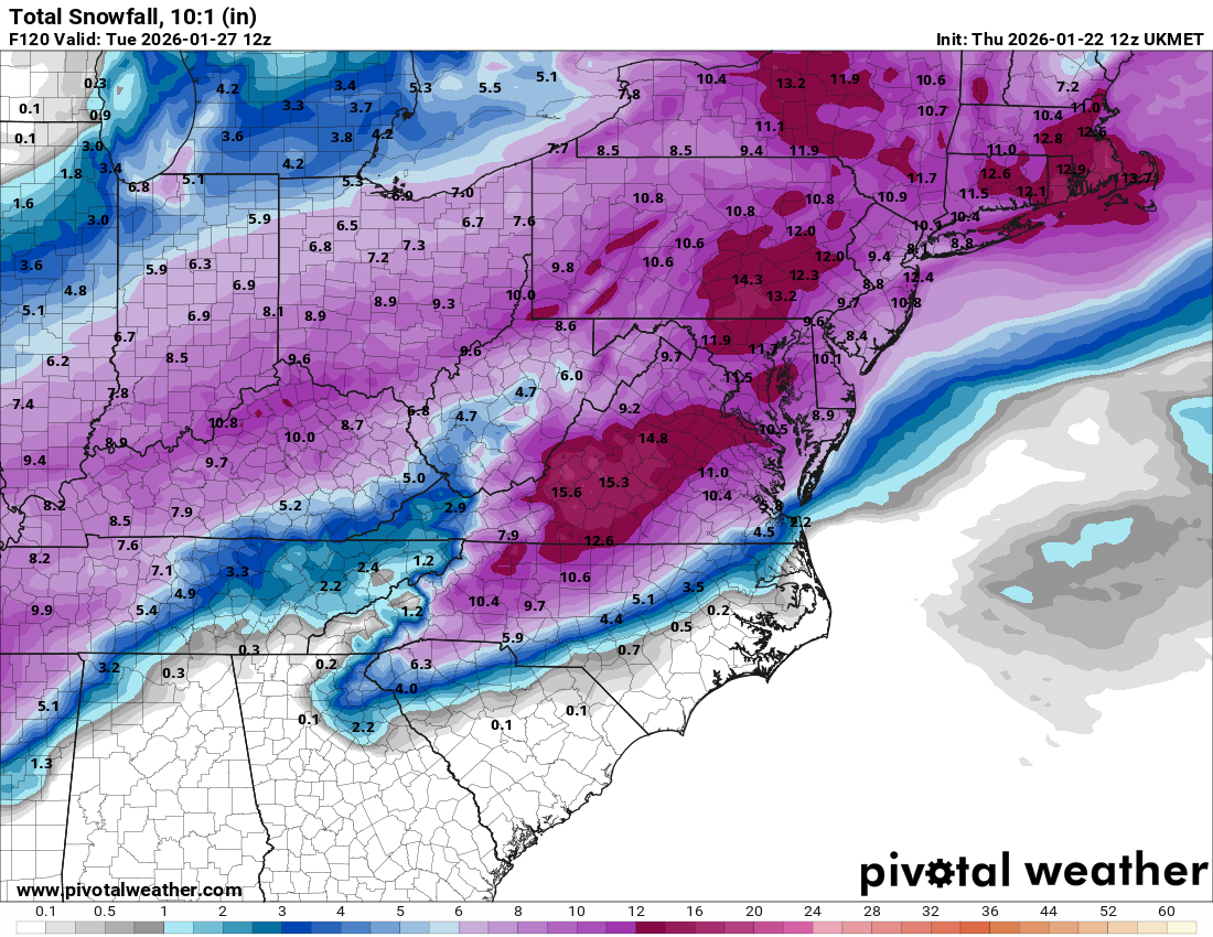
TWC earlier today forecasted approx 12-14 inches for CNJ
TWC earlier today forecasted approx 12-14 inches for CNJ
let's draw him in...Nailed it. But I also enjoy the smack talk. Hoping Nimbers can't help himself and posts a few times in bac's great thread.

let's draw him in...
These might be too “inside baseball” for some in the thread.Offer a free Rutgers t shirt and he'll be here.
Get on it Gov Mikie
You sound salty. Maybe they can run the street sweepers through my town and collect all the loose salt on roadsThere wouldn't be a shortage if they stopped salting in rain.
Based on model trends they will be lowering those percentagesAt 5 a.m.,the National Weather Service in Mount Holly issued the briefing I've linked below. As you can see, the NWS believes at least six inches of snow is a certainty and only a 10% chance of less than 10 inches of snow in the forecast area. There is a 50% chance of more than a foot of snow, according to the briefing. The snow may mix with sleet or freezing rain or perhaps even plain rain in the southern part of the area, which of course would make things worse. Bitter cold is then expected for several nights. Be safe, everyone!
https://www.weather.gov/media/phi/current_briefing.pdf
Highly premature to post those amounts. NWS must be taking info from the other thread.Based on model trends they will be lowering those percentages
Only if he can knock over a little kid to get to it!Offer a free Rutgers t shirt and he'll be here.
Looking more like mix/rain working its way in. It wouldn’t surprise me if they cut totals drastically in the next two days
over salting is the new norm. Can't have any left over for budget reasons I believeThere wouldn't be a shortage if they stopped salting in rain.


yep this is true all over the country, municipalities are buying up all the salt and there is little left for private contractors who then have to absorb an inflated price when they do find salt. In the 70s and 80s there was never this much salt put out. Lol remember they used sand even. It started in the 90s but it was in the 2000s that things became ridiculous. People having it too good, add in an influx of inexperienced drivers not used to snow in this part of the country.over salting is the new norm. Can't have any left over for budget reasons I believe
agree 100% and yes, I remember sand too! I prefer the sand actuallyyep this is true all over the country, municipalities are buying up all the salt and there is little left for private contractors who then have to absorb an inflated price when they do find salt. In the 70s and 80s there was never this much salt put out. Lol remember they used sand even. It started in the 90s but it was in the 2000s that things became ridiculous. People having it too good, add in an influx of inexperienced drivers not used to snow in this part of the country.
yep and some mid to upper 40s as I told you earlier in the week and Numbers was wrong again10 am and 43 out. Feels like spring.
back when i was a youth they used to spread sand all over the road, talk about messing up your sleigh riding!You sound salty. Maybe they can run the street sweepers through my town and collect all the loose salt on roads
Warm air aloft will cause sleet with surface temps below freezing. So it could be 26 and prolonged sleetThis is wild !
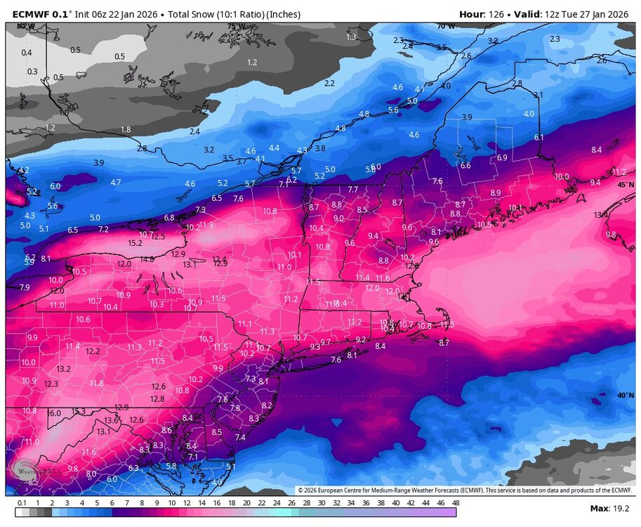
Looks like Bac s model above makes most sense as of now.
7 inches or thereabouts seems feasible / reasonable for CNJ given the mixing which is hard to understand given temps are way below 32.
Guess it’s atmospheric differences etc.
I listed ranges as of this morning early on other thread for Monmouth which were :
Masco : 4-6
Zarriw : 6
TWC : 12-18
FWC : 18-24
Looks like sleet and rain will suppress snow totals
thats decent early...further runs may cut back on totals as these overruning events with warm noses tend to go to sleet earlier than models show.I’m thinking 8-12 is a good bet for central jersey. Even if it dies mix at the end - the initial dump of snow is major.
Could see 12+ in north Jersey and 6-10 in south Jersey.
This would be my first call.

People having it too good, add in an influx of inexperienced drivers not used to snow in this part of the country.
do they even exist anymorePlus does anyone ever get snow tires now?
Actually, my adult kid did this in Wisconsin for a Mazda 3. It's apparently a thing out there, and the tire store places your "regular" tires in storage and changes them in the Spring. The tires mad a big difference on the Mazda 3.Plus does anyone ever get snow tires now?
do they even exist anymore
Actually, my adult kid did this in Wisconsin for a Mazda 3. It's apparently a thing out there, and the tire store places your "regular" tires in storage and changes them in the Spring. The tires mad a big difference on the Mazda 3.
Definitely still a thing If you have a performance car - I run high performance summer tires in the summer and switch to winter performance tires in the fall on my RS5. The summer tires lose traction once you get much below 40F - definitely would be dangerous in snow.Actually, my adult kid did this in Wisconsin for a Mazda 3. It's apparently a thing out there, and the tire store places your "regular" tires in storage and changes them in the Spring. The tires mad a big difference on the Mazda 3.