OT: Tracking Winter Storm Fern 1/25-26

bac2therac

Hall of Famer
Jul 30, 2001
243,501
173,251
113
Gfs still not backing down. 12-20 inches thru much of central and northern nj.

Its less actually more like 12-14 and down to 5-8 at coast south of toms river.it moved ever so slightly to the other models and not as cold especially in latter stages

The models now are all showing the warm air and sleet coming but whats interesting us the qpfs have ticked up so accumulation wise that thump of heavy snow still 7-10 inches constant
 
  • Like
Reactions: T2Kplus20

Mikemarc

Heisman
Nov 28, 2005
69,178
17,866
97
Its less actually more like 12-14..it moved ever so slightly to the other models and not as cold especially in latter stages

The models now are all showing the warm air and sleet coming but whats interesting us the qpfs have ticked up so accumulation wise that thump of heavy snow still 7-10 inches constant

kuchera is 12-20 thruout the top 2/3rds of the state.

 
  • Like
Reactions: thegock

bac2therac

Hall of Famer
Jul 30, 2001
243,501
173,251
113
Ukie a bit weird with dryslotting for nyc cutting their qpf. Not as juicy for rest with sleet toward end but not before thumping 6-10 inches
 

bac2therac

Hall of Famer
Jul 30, 2001
243,501
173,251
113
no what?

it’s significantly more accurate than the 10:1 ratio..especially in a storm like this. And yes, I agree the gfs is on an island but it’s worth noting it’s been consistent all day.
Its not consistent its becoming warmer and its shorter duration
 

bac2therac

Hall of Famer
Jul 30, 2001
243,501
173,251
113
The Euro still to come

But ive seen enough to make my first call 54 hours out...and being a first call this will change at least once before final call

8-12 inches Central Jersey up to Newark/NYC that could see as little as 6 if sleet mix moves in quicker and if sleet is delayed or never materializes we see the 12-14 inch totals

10-14 inches N of 78 to Nw NJ. If sleet reaches these areas could cut down to 8. Colder air could make for high ratios and 16 inch amounts in sweet spots


6-9 inches monmouth/ocean/philly/south jersey. Could approach 12 inches if warm nose does not materialize

Coastal south jersey 3-6.
 

Mikemarc

Heisman
Nov 28, 2005
69,178
17,866
97
The Euro still to come

But ive seen enough to make my first call 54 hours out...and being a first call this will change at least once before final call

8-12 inches Central Jersey up to Newark/NYC that could see as little as 6 if sleet mix moves in quicker and if sleet is delayed or never materializes we see the 12-14 inch totals

10-14 inches N of 78 to Nw NJ. If sleet reaches these areas could cut down to 8. Colder air could make for high ratios and 16 inch amounts in sweet spots


6-9 inches monmouth/ocean/philly/south jersey. Could approach 12 inches if warm nose does not materialize

Coastal south jersey 3-6.

solid call.
 

Mikemarc

Heisman
Nov 28, 2005
69,178
17,866
97
If it was consistent that mix iine wouldnt be moving thru nj

its been consistent with its totals. Obviously no model is gonna be EXACTLY the same run to run. But for the GFS - yes it’s been very consistent. Again, agree to disagree here.
 

bac2therac

Hall of Famer
Jul 30, 2001
243,501
173,251
113
solid call.
Thank you. I think its fair at the moment giving nods to under and over performance

There is alot of qpf. We will thump heavy snow for a time. How long is the question? Alot of times these overrunning events flip to sleet sooner like earlier this year. Sometimes we snow 2inches an hour for several hours. Other times by the time it flip most of precip is done or underperforms
 
  • Like
Reactions: dark_check

Postman_1

Heisman
Mar 12, 2017
7,864
12,713
113
the 0z NAM is warm aloft.....4-9 inches on regular map and only slightly more on kuchera and really slices total south on the other side of GSP

I'm thinking this is more accurate then most. The past few years we have seen these crazy snow maps throw out very high numbers and come storm time the amount most always is less. Every morning the storm seems to be shifting more and more north. By Sunday am it would not shock me if my area (Mercer) was at 4-6" at best
 

bac2therac

Hall of Famer
Jul 30, 2001
243,501
173,251
113
0z Euro really was only 6-9 inches

But 6z nam was even warmer and continues to sniff out the warm nose. Its traditionally deadly. Verbatim it would cut totals drastically. Has Central Jersey in sleet by 3 pm. Sleet all the way through NW Jersey. Only showing 4-8 inches of snow

Weenies are concerned.

Mt Holly even before the 6z NAM seem destined and so stubborn following the NBM they will not budge off their 12-18 forecast but now trying to save some face with a circle down around Central Jersey. There appear to be areas near the coast they will massively bust unless they reduce their map somewhat

Gfs remains on it own with 10-16...even as much as 20 so Mt Holly must be giving it alot of weight
 
Last edited:
  • Like
Reactions: Postman_1

ru109

All-American
Sep 18, 2011
6,887
5,392
113
TWC is still calling for 12-20 inches of snow up by me. My snow blower is gassed up and ready to go so I'm set.
 

Retired711

Heisman
Nov 20, 2001
19,845
10,021
58
The NWS updated its briefing at 5 a.m. It is calling for 12-18 inches for most of NJ, but for that to be closer to 12 inches for an area stretching to almost Morristown in the north, the shore from just south of NYC to Toms River along the shore, and a little south of Wilmington. It projects 8-12 inches for an area stretching along the shore from just south of Toms River to Cape May, and including Easton, Dover and Vineland. The lower amounts, as you would expect, are from changeover from snow to sleet/freezing rain.

The NWS is now saying that "the threat has increased for potentially significant ice accumulations across the
I-95 corridor, Eastern Shore of Maryland, and central/northern Delaware.The combination of heavy snow
followed by sleet/freezing rain could result in downed trees and power outages."

Finally, it is saying that "a prolonged period of well below normal temperatures is expected to continue through next week, with wind chills in the single digits to below zero each night."

https://www.weather.gov/media/phi/current_briefing.pdf

The forecast for my Cherry Hill zip code is for 2-4 inches Saturday night and an additional 7-11 inches on Sunday, with maybe a little more Sunday night and Monday. The changeover from snow to snow/freezing rain is supposed to happen about 1 p.m. on Sunday afternoon.
 

Knight Shift

Heisman
May 19, 2011
87,816
85,505
113
0z Euro really was only 6-9 inches

But 6z nam was even warmer and continues to sniff out the warm nose. Its traditionally deadly. Verbatim it would cut totals drastically. Has Central Jersey in sleet by 3 pm. Sleet all the way through NW Jersey. Only showing 4-8 inches of snow

Weenies are concerned.

Mt Holly even before the 6z NAM seem destined and so stubborn following the NBM they will not budge off their 12-18 forecast but now trying to save some face with a circle down around Central Jersey. There appear to be areas near the coast they will massively bust unless they reduce their map somewhat

Gfs remains on it own with 10-16...even as much as 20 so Mt Holly must be giving it alot of weight
How about in English. WTF is a "warm nose." Models? Any consensus?

Could not find/see Lee Goldberg's updates.
Mike Woods from Fox5NY says 3-6 all the way up to NYC.

Posted at 4:45 a.m. by ABC7NY:
 
Last edited:

bac2therac

Hall of Famer
Jul 30, 2001
243,501
173,251
113
How about in English. WTF is a "warm nose." Models? Any consensus?

Could not find/see Lee Goldberg's updates.
Mike Woods from Fox5NY says 3-6 all the way up to NYC.

Posted at 4:45 a.m. by ABC7NY:
warm nose is warm air pushing aloft...i was mentioning it yesterday and the NAM a mesoscale short term model is very good at it and now its in range. The GFS the snowiest model albeit consistent is terrible at this. The higher rates Mt Holly is clinging to relied on heavy rates for longer duration with high ratios. Well we will get a heavy thump initially with higher ratios but its becoming clear not for as long as other models are backing that up. The Euro wasnt all that impressive last night and no one is talking about that. Still a day of models to go that could change things but we are moving away from a widespread 10-20 inch event

12z nam running now
 

bac2therac

Hall of Famer
Jul 30, 2001
243,501
173,251
113
Zarrow has cut his totals in his morning update


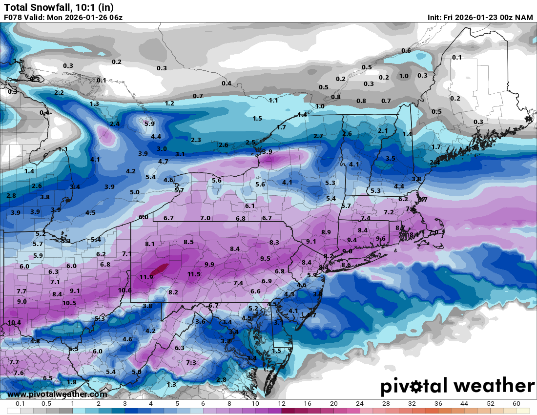
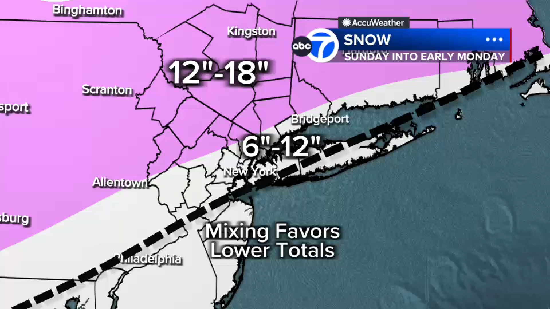
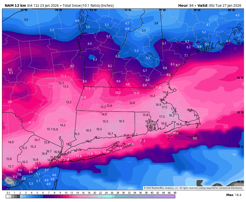
For northern New Jersey, approximately along and north of Interstate 78, 10 to 15 inches of snow is expected. Double-digit snowfall is serious business. It will be dry, powdery snow, accumulating at a rate of 1-2" per hour during the height of the storm. It is not impossible that this area sees a bit of sleet at the tail end of the storm Sunday evening, but snow will still be the dominant precipitation type.

For southwestern and central New Jersey — most of the state — I now believe 7 to 10 inches of a good estimation of total snowfall. Squarely in the "major" winter storm category. It would be more, but the potential switch to sleet Sunday afternoon cuts things off.

Along the southern coast, not only will snow change to icy mix, but also a transition to rain is expected from late Saturday afternoon into Saturday evening as surface temperatures rise into the mid 30s. I have to keep snow totals lower here, around 4 to 7 inches. That falls in the "moderate to heavy" snow category.

Could these snow totals go up again, if the forecast trends colder and snowier? Sure.

Could they go down further, if things keep drifting warmer and icier? Yes.

But this is the best call I can make using the data and information available at this time.

5.) Storm Timeline: Four Phases​

Phase 1: First Flakes... Initial snowflakes could enter southwestern New Jersey as early as Saturday evening, but realistically light snow will hold off until early Sunday morning (after Midnight). It will take a little while for the very cold and dry air to moisten up enough for substantial snow to fall, but it will happen eventually. The ground will be cold enough for snow to stick and accumulate immediately, which could happen by daybreak. That means road conditions will start going downhill by mid-morning Sunday.

Phase 2: Moderate to Heavy Snow... Sunday morning through midday, bands of snow will fall and accumulate. Some models show pockets of 1-2" per hour snowfall is possible, which will lead to low visibility and fast accumulations

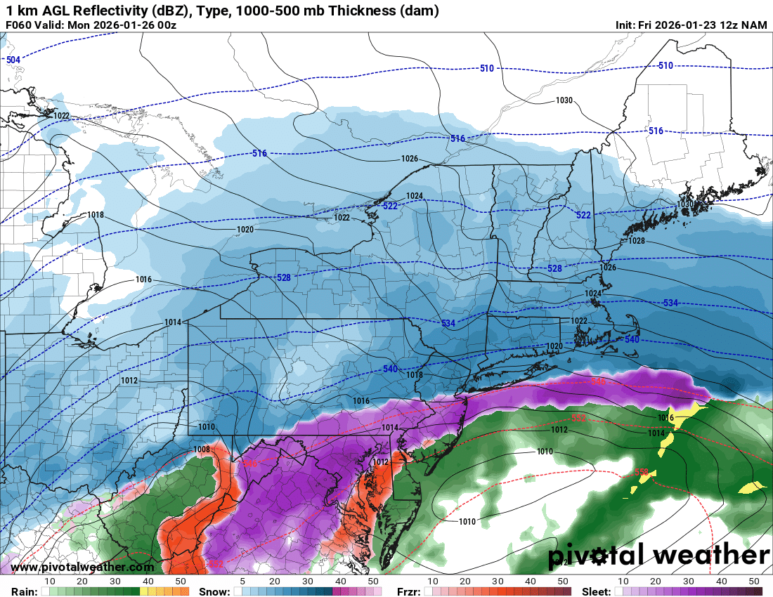
Phase 3: Transition to Icy Mix... As warmer air penetrates the middle layers of the atmosphere, snow will likely changeover to an icy mix of snow and mainly sleet through Sunday afternoon. First along the coast, then progressing across southwestern and central New Jersey. Coastal areas could even warm enough in the lower and middle portions of the atmosphere to flip over to plain rain.

Phase 4: Lingering Snow Showers... It looks like the storm will start to peter out and move away by Sunday evening. I think we should see improving conditions by 9 or 10 p.m. There will still be lingering snow showers through the overnight into Monday morning. And definitely lingering travel disruptions


Read More: 7 things to know about this weekend's wild wintry weather in NJ | https://nj1015.com/nj-weather-cold-snow-ice-weekend/?utm_source=tsmclip&utm_medium=referral
 

NickRU714

Heisman
Aug 18, 2009
13,807
12,569
113
Suggestions on shoveling strateg?

Obviously dont want to wait til its over and spend 7 hours shoveling 12" of snow Monday morning.

Put down salt Sunday morning?
Shovel every couple of inches?
No salt until it's done?
 
  • Wow
Reactions: newell138

Knight Shift

Heisman
May 19, 2011
87,816
85,505
113
warm nose is warm air pushing aloft...i was mentioning it yesterday and the NAM a mesoscale short term model is very good at it and now its in range. The GFS the snowiest model albeit consistent is terrible at this. The higher rates Mt Holly is clinging to relied on heavy rates for longer duration with high ratios. Well we will get a heavy thump initially with higher ratios but its becoming clear not for as long as other models are backing that up. The Euro wasnt all that impressive last night and no one is talking about that. Still a day of models to go that could change things but we are moving away from a widespread 10-20 inch event

12z nam running now
Thank you.
News 12 NJ has 6-9 inches for "Central NJ" with less South of Barnegat
Not trying to derail this, but where the hell is Central Jersey…both the threads only focus on CNJ but I couldn’t tell you where it is
Frustrating, ain't it? For weather reports, it's a sliding boundary.

News12NJ just said down to about Sayreville 9-12+ possible, with higher amounts in NW NJ (Sussex, NW Morris). He drew a diagonal line and said Central NJ stopped in South Middlesex County (probably Jamesburg, etc?).

The problem is nobody knows what will happen with the warm, runny nose (warm air pushing aloft).

Bottom line, is most reports agree a minimum of 6" for all of NJ, except along the coast, especially Ocean County and South, but that could push further north or further South. Monmouth and Ocean will follow with a coating of sleet, which could make cleanup worse.
 

Knight Shift

Heisman
May 19, 2011
87,816
85,505
113
Suggestions on shoveling strateg?

Obviously dont want to wait til its over and spend 7 hours shoveling 12" of snow Monday morning.

Put down salt Sunday morning?
Shovel every couple of inches?
No salt until it's done?
That depends on your level of fitness and your "need" to travel and if you plan to have visitors or deliveries.
For storms like these, we like to clear the driveway for every 4-6". Sometimes, will do a first pass with the snowblower, and then use a 36" teflon snow pusher for every 2 inches after that. The snow pusher has been an awesome addition to our snow clearing tools. My better half wants one too because it is so effective at clearing 2-3" of snow.
 

Sweet Pea's Corner

All-American
Sep 10, 2001
17,432
5,341
113
Suggestions on shoveling strateg?

Obviously dont want to wait til its over and spend 7 hours shoveling 12" of snow Monday morning.

Put down salt Sunday morning?
Shovel every couple of inches?
No salt until it's done?
Do what u can. Sure everyone wants a a clean driveway absolutely sidewalk but is it really imperative that you get it to the bare bone? I'm been in snow removal.for 40 years and I know we won't get everyone down to the bone because of the sleet. We cant do everyone 2 or 3 times..we wait till it ends. Then throw down some salt.
 

bac2therac

Hall of Famer
Jul 30, 2001
243,501
173,251
113
12z NAM play by play

snow moves into NJ shortly after midnight which is quicker than previously modelled.
by 10am mixing showing up in extreme south jersey
by 1 pm mix line rapidly moving to 195 just north of trenton cutting state in half


still a decent thump before that laying down 5-8
however by 4pm the mix line has stalled or even moved south...very interesting development prolonging frozen


nam is a better run for those wanting frozen an improvement from its previous runs. However is it noise or not.
7 pm the sleet line has moved slightly north again around the 195 area


10pm starting to wind down holding sleet line in place


then 1 am dry slot


wow so this is a significant change. Now I see the 3K Nam moves that mix line further north so everything is still up in the air you can see how a small shift 25-50 miles can have a signficant impact.


Huge numbers here and this is just 10-1 not Kuchera.....is it one of those we have been NAMd runs that they always give us. 12-16 north of 78 to Newark NYC. 8-12 trenton to 78 through middlesex county and 4-6 for monmouth, ocean coast and sj


bac2therac

Hall of Famer
Jul 30, 2001
243,501
173,251
113
Suggestions on shoveling strateg?

Obviously dont want to wait til its over and spend 7 hours shoveling 12" of snow Monday morning.

Put down salt Sunday morning?
Shovel every couple of inches?
No salt until it's done?
where do you live..if its north jersey you are likely all snow and you need to do it in stages since 12 inches plus isnt pretty to do

if you are further south where sleet will fall you are in a damned if you do damned if you dont situation...remove some snow before changeover but here is the problem, if you remove all the snow and then 2 inches of sleet falls on the ground its almost impossible to shovel sleet. if there is a little based of snow on the bottom of the sleet you perhaps might be able to chip a tunnel and then be able to lift. Either way it will not be easy

and yes everyone needs to grab wife and kids and get out there because this stuff isnt going away for 2 weeks at least. Its going to be one big glacier of ice everywhere once it freezes sometime monday night, it will still be in the 20s monday morning but you can get alot of it done before it deep freezes...its a shame that i never see kids shovelling anymore...when i was a kid the whole family including my mother was out there and my father did what he could do but he had heart issues and shouldnt have been doing it at all.

we have lazy group of children in society..how dare they pick up a shovel
 

bac2therac

Hall of Famer
Jul 30, 2001
243,501
173,251
113
closer look at nam map...what a difference a few miles will make..such a tough forecast, impossible to pin down


thegock

All-Conference
Jul 30, 2012
1,177
1,124
113
How about in English. WTF is a "warm nose." Models? Any consensus?

Could not find/see Lee Goldberg's updates.
Mike Woods from Fox5NY says 3-6 all the way up to NYC.

Posted at 4:45 a.m. by ABC7NY:

This will put a damper on what has been a great fatbiking winter so far.
 
  • Like
Reactions: Knight Shift

Doteman5

Redshirt
Aug 13, 2025
20
28
13
My folks live in Lanoka Harbor just south of Toms River near coast. The Weather Channel still has them for 12-18 inches, crazy. That area busts almost every time, very poorly forecasted there. They need to drop this significantly. TWC still has my in-laws in Milton, DE with 8-15
 

hankee18

All-American
Jan 18, 2006
4,116
7,405
113
where do you live..if its north jersey you are likely all snow and you need to do it in stages since 12 inches plus isnt pretty to do

if you are further south where sleet will fall you are in a damned if you do damned if you dont situation...remove some snow before changeover but here is the problem, if you remove all the snow and then 2 inches of sleet falls on the ground its almost impossible to shovel sleet. if there is a little based of snow on the bottom of the sleet you perhaps might be able to chip a tunnel and then be able to lift. Either way it will not be easy

and yes everyone needs to grab wife and kids and get out there because this stuff isnt going away for 2 weeks at least. Its going to be one big glacier of ice everywhere once it freezes sometime monday night, it will still be in the 20s monday morning but you can get alot of it done before it deep freezes...its a shame that i never see kids shovelling anymore...when i was a kid the whole family including my mother was out there and my father did what he could do but he had heart issues and shouldnt have been doing it at all.

we have lazy group of children in society..how dare they pick up a shovel

We were required to shovel the driveway before any type of sledding etc. But you didnt even have to ask, my brother and I just loved being out there in the snow all day

My kids help, but I have to ask, certainly not like the old days
 
  • Like
Reactions: MulletCork

Knight Shift

Heisman
May 19, 2011
87,816
85,505
113
We were required to shovel the driveway before any type of sledding etc. But you didnt even have to ask, my brother and I just loved being out there in the snow all day

My kids help, but I have to ask, certainly not like the old days
Starvation tactics work well . . . . . . :ROFLMAO:
 
  • Like
Reactions: hankee18