yeah I dont see any model maybe the gfs that even comes close to that amount there.My folks live in Lanoka Harbor just south of Toms River near coast. The Weather Channel still has them for 12-18 inches, crazy. That area busts almost every time, very poorly forecasted there. They need to drop this significantly. TWC still has my in-laws in Milton, DE with 8-15
OT: Tracking Winter Storm Fern 1/25-26
- Thread starter bac2therac
- Start date
You are using an out of date browser. It may not display this or other websites correctly.
You should upgrade or use an alternative browser.
You should upgrade or use an alternative browser.

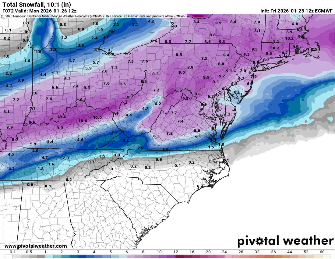
RGEM shorter term models has mixing up into north jersey and central jersey by 4pm....verbatim is 6-10 region wide..also less qpf than other models

That's a little bit of a blanket statement. Kids in my town shovel and their parents even promote their services on the town FB page.where do you live..if its north jersey you are likely all snow and you need to do it in stages since 12 inches plus isnt pretty to do
if you are further south where sleet will fall you are in a damned if you do damned if you dont situation...remove some snow before changeover but here is the problem, if you remove all the snow and then 2 inches of sleet falls on the ground its almost impossible to shovel sleet. if there is a little based of snow on the bottom of the sleet you perhaps might be able to chip a tunnel and then be able to lift. Either way it will not be easy
and yes everyone needs to grab wife and kids and get out there because this stuff isnt going away for 2 weeks at least. Its going to be one big glacier of ice everywhere once it freezes sometime monday night, it will still be in the 20s monday morning but you can get alot of it done before it deep freezes...its a shame that i never see kids shovelling anymore...when i was a kid the whole family including my mother was out there and my father did what he could do but he had heart issues and shouldnt have been doing it at all.
we have lazy group of children in society..how dare they pick up a shovel
Just what i observeThat's a little bit of a blanket statement. Kids in my town shovel and their parents even promote their services on the town FB page.
Canadian model has mixing up all the way through Somerset County by evening Sunday....8-11 inches region wide
I said above that the NWS says that in my area (Cherry Hill) there will be a changeover from snow to snow/freezing rain on Sunday afternoon. But they think there may be a shift back to snow about 4 a.m. that night. If this is right, we will have a little snow on top of freezing rain and then snow below it. I am surprised there is no mention of sleet.
yeah some models to have lingering precip or wrap round even later on Monday but its often hard to count onI said above that the NWS says that in my area (Cherry Hill) there will be a changeover from snow to snow/freezing rain on Sunday afternoon. But they think there may be a shift back to snow about 4 a.m. that night. If this is right, we will have a little snow on top of freezing rain and then snow below it. I am surprised there is no mention of sleet.
i think mt holly is going to have to slice those totals for your area soon
Ukie is general 8-10 inches it has a weird dryslot near nyc where they only have 5-6
these percentages dont even match their forecast...if they are saying 14 for most of nj on their map yet the percentages of greater than 12 for many of these areas are 37% or less
��
|
where do you live..if its north jersey you are likely all snow and you need to do it in stages since 12 inches plus isnt pretty to do
if you are further south where sleet will fall you are in a damned if you do damned if you dont situation...remove some snow before changeover but here is the problem, if you remove all the snow and then 2 inches of sleet falls on the ground its almost impossible to shovel sleet. if there is a little based of snow on the bottom of the sleet you perhaps might be able to chip a tunnel and then be able to lift. Either way it will not be easy
and yes everyone needs to grab wife and kids and get out there because this stuff isnt going away for 2 weeks at least. Its going to be one big glacier of ice everywhere once it freezes sometime monday night, it will still be in the 20s monday morning but you can get alot of it done before it deep freezes...its a shame that i never see kids shovelling anymore...when i was a kid the whole family including my mother was out there and my father did what he could do but he had heart issues and shouldnt have been doing it at all.
we have lazy group of children in society..how dare they pick up a shovel
Just above 78 at the Union/Morris/Somerset County intersection.
Will have to play it by ear.
If I lived closer to you, I would stop by and help you shovel as we debate various Rutgers football topics. But sorry, too far, I'm down at the Monmouth/Ocean border.Just above 78 at the Union/Morris/Somerset County intersection.
Will have to play it by ear.
Patterson moonlight as a meteorologist?
Whoops. There is a hidden message with the local weather-it will be a cold day at Rutgers before we hire a DC!Patterson moonlight as a meteorologist?
well you may stay all snow and get at least 10...the thing is in the afternoon its coming down at least an inch an hour so piling up alot quickly...stages recommendedJust above 78 at the Union/Morris/Somerset County intersection.
Will have to play it by ear.
Translation please. . . . .
i dont know but does seem like he is forecasting for our area
Mt holly not really budging...sliced a tiny bit...10-15 inches
NJZ008>010-012>015-020-026-PAZ060-103-105-106-241100-
/O.UPG.KPHI.WS.A.0001.260125T0600Z-260126T1800Z/
/O.NEW.KPHI.WS.W.0001.260125T0000Z-260126T1800Z/
Morris-Hunterdon-Somerset-Middlesex-Western Monmouth-Eastern
Monmouth-Mercer-Ocean-Coastal Ocean-Berks-Western Montgomery-
Upper Bucks-Lower Bucks-
Including the cities of New Brunswick, Long Beach Island,
Perkasie, Reading, Trenton, Pottstown, Somerville, Sandy Hook,
Collegeville, Flemington, Freehold, Jackson, Morrisville,
Doylestown, Morristown, and Chalfont
1238 PM EST Fri Jan 23 2026
...WINTER STORM WARNING IN EFFECT FROM 7 PM SATURDAY TO 1 PM EST
MONDAY...
* WHAT...Heavy snow with mixed precipitation expected. Total snow
accumulations between 10 and 15 inches and ice accumulations
around one tenth of an inch.
* WHERE...Portions of New Jersey and southeast Pennsylvania.
* WHEN...From 7 PM Saturday to 1 PM EST Monday.
* IMPACTS...Travel could be very difficult to impossible. The
hazardous conditions could impact the Monday morning commute.
PRECAUTIONARY/PREPAREDNESS ACTIONS...
If you must travel, keep an extra flashlight, food, and water in
your vehicle in case of an emergency. The latest road conditions for
the state you are calling from can be obtained by calling 5 1 1.

did cut for philly and so jersey but to be honest this should extend up to south of 78, middlesex monmouth
/O.UPG.KPHI.WS.A.0001.260125T0000Z-260126T1800Z/
/O.NEW.KPHI.WS.W.0001.260125T0000Z-260126T1800Z/
New Castle-Kent-Kent MD-Queen Annes-Talbot-Caroline-Salem-
Gloucester-Camden-Northwestern Burlington-Cumberland-Southeastern
Burlington-Delaware-Philadelphia-Western Chester-Eastern Chester-
Eastern Montgomery-
Including the cities of West Chester, Glassboro, Cherry Hill,
Media, Camden, Philadelphia, Norristown, Dover, Millville,
Centreville, Lansdale, Wilmington, Easton, Moorestown, Denton,
Wharton State Forest, Pennsville, Chestertown, Honey Brook,
Kennett Square, Oxford, and Mount Holly
1238 PM EST Fri Jan 23 2026
...WINTER STORM WARNING IN EFFECT FROM 7 PM SATURDAY TO 1 PM EST
MONDAY...
* WHAT...Heavy snow and mixed precipitation expected. Total snow
accumulations between 8 and 12 inches and ice accumulations around
three tenths of an inch.
* WHERE...Portions of central and northern Delaware, northeast
Maryland, southern New Jersey, and southeast Pennsylvania.
* WHEN...From 7 PM Saturday to 1 PM EST Monday.
* IMPACTS...Significant ice accumulation on power lines and tree
limbs may cause widespread and long-lasting power outages. Power
outages and tree damage are likely due to the ice. Travel could be
nearly impossible. The hazardous conditions could impact the
Monday morning commute.
PRECAUTIONARY/PREPAREDNESS ACTIONS...
If you must travel, keep an extra flashlight, food, and water in
your vehicle in case of an emergency. The latest road conditions for
the state you are calling from can be obtained by calling 5 1 1.
&&
Bac, whose forecasts are these?these percentages dont even match their forecast...if they are saying 14 for most of nj on their map yet the percentages of greater than 12 for many of these areas are 37% or less
��
Location Low-End
AmountExpected
AmountHigh-End
AmountChance of Seeing More Than 0.1" .1 1" 2" 4" 6" 8" 12" 18" Allentown, PA 7" 14" 17" 100% 100% 100% 98% 96% 86% 53% 5% Atlantic City, NJ 3" 9" 11" 100% 100% 96% 85% 47% 34% 4% 0% Bethany Beach, DE 1" 7" 8" 100% 96% 84% 47% 32% 16% 0% 0% Cape May, NJ 2" 9" 11" 100% 97% 93% 66% 42% 31% 1% 0% Centreville, MD 3" 11" 13" 100% 100% 99% 89% 64% 42% 19% 0% Cherry Hill, NJ 5" 13" 16" 100% 100% 100% 95% 83% 59% 33% 0% Chestertown, MD 4" 11" 13" 100% 100% 99% 93% 74% 48% 18% 0% Clinton, NJ 7" 14" 17" 100% 100% 100% 98% 94% 86% 44% 5% Coatesville, PA 7" 14" 17" 100% 100% 100% 98% 95% 85% 41% 5% Denton, MD 2" 10" 12" 100% 100% 97% 81% 48% 38% 14% 0% Dover, DE 4" 11" 13" 100% 100% 98% 91% 65% 43% 19% 0% Doylestown, PA 6" 14" 17" 100% 100% 100% 96% 91% 76% 39% 5% Easton, MD 3" 10" 12" 100% 100% 97% 78% 48% 37% 13% 0% Flemington, NJ 7" 14" 17" 100% 100% 100% 97% 93% 81% 42% 7% Freehold, NJ 5" 16" 19" 100% 100% 100% 96% 89% 71% 40% 16% Georgetown, DE 2" 9" 11" 100% 99% 92% 71% 44% 33% 5% 0% Glassboro, NJ 5" 12" 15" 100% 100% 99% 94% 80% 52% 29% 0% Hackettstown, NJ 7" 15" 18" 100% 100% 100% 99% 96% 88% 59% 12% Jim Thorpe, PA 8" 16" 19" 100% 100% 100% 99% 96% 90% 65% 16% Joint Base MDL, NJ 5" 15" 18" 100% 100% 100% 96% 84% 60% 36% 10% King of Prussia, PA 6" 13" 16" 100% 100% 100% 97% 92% 71% 35% 1% LBI, NJ 3" 9" 11" 100% 100% 98% 86% 57% 38% 8% 0% Long Branch, NJ 5" 16" 20" 100% 100% 100% 95% 84% 66% 39% 19% Mays Landing, NJ 4" 11" 13" 100% 100% 98% 91% 68% 45% 19% 0% Media, PA 5" 13" 16" 100% 100% 100% 96% 85% 71% 34% 1% Middletown, DE 5" 12" 15" 100% 100% 99% 93% 82% 49% 29% 0% Milford, DE 3" 10" 12" 100% 99% 95% 83% 50% 39% 16% 0% Morristown, NJ 7" 14" 17" 100% 100% 100% 98% 95% 87% 50% 9% Mount Holly, NJ 5" 14" 17" 100% 100% 100% 95% 84% 63% 35% 4% Mount Pocono, PA 8" 17" 21" 100% 100% 100% 100% 97% 92% 75% 24% Nazareth, PA 7" 15" 18" 100% 100% 100% 99% 96% 88% 61% 10% New Brunswick, NJ 6" 13" 16" 100% 100% 100% 96% 91% 77% 37% 2% Philadelphia, PA 5" 13" 16" 100% 100% 100% 95% 84% 64% 33% 0% Reading, PA 7" 14" 16" 100% 100% 100% 98% 96% 88% 49% 4% Salem, NJ 5" 12" 14" 100% 100% 99% 94% 81% 50% 26% 0% Seaford, DE 2" 10" 12" 100% 99% 92% 71% 45% 36% 13% 0% Smyrna, DE 4" 11" 13" 100% 100% 99% 92% 75% 45% 19% 0% Somerville, NJ 6" 13" 16" 100% 100% 100% 96% 91% 77% 37% 1% Sussex, NJ 7" 14" 17" 100% 100% 100% 100% 96% 89% 63% 7% Tabernacle, NJ 4" 15" 18" 100% 100% 100% 95% 82% 58% 36% 10% Toms River, NJ 4" 12" 14" 100% 100% 99% 93% 80% 49% 26% 0% Trenton, NJ 5" 14" 17" 100% 100% 100% 96% 89% 72% 37% 5% Vineland, NJ 4" 11" 13" 100% 100% 98% 91% 75% 46% 21% 0% Wantage, NJ 7" 14" 17" 100% 100% 100% 100% 96% 89% 64% 9% West Chester, PA 6" 13" 16" 100% 100% 100% 97% 92% 76% 36% 2% Wilmington, DE 5" 13" 16" 100% 100% 100% 95% 85% 58% 32% 0%
still a bit high here
Inland Sussex-Delaware Beaches-Atlantic-Cape May-Atlantic Coastal
Cape May-Coastal Atlantic-
Including the cities of Rehoboth Beach, Ocean City, Atlantic
City, Cape May Court House, Hammonton, and Georgetown
1238 PM EST Fri Jan 23 2026
...WINTER STORM WARNING IN EFFECT FROM 7 PM SATURDAY TO 7 AM EST
MONDAY...
* WHAT...Heavy snow with mixed precipitation expected. Total snow
accumulations between 6 and 10 inches and ice accumulations around
one tenth of an inch. Winds gusting as high as 35 mph.
* WHERE...Portions of southern Delaware and southern New Jersey.
* WHEN...From 7 PM Saturday to 7 AM EST Monday.
* IMPACTS...Travel could be very difficult. The hazardous conditions
could impact the Monday morning commute.
I don't care about the snow, but that ice really worries me.did cut for philly and so jersey but to be honest this should extend up to south of 78, middlesex monmouth
/O.UPG.KPHI.WS.A.0001.260125T0000Z-260126T1800Z/
/O.NEW.KPHI.WS.W.0001.260125T0000Z-260126T1800Z/
New Castle-Kent-Kent MD-Queen Annes-Talbot-Caroline-Salem-
Gloucester-Camden-Northwestern Burlington-Cumberland-Southeastern
Burlington-Delaware-Philadelphia-Western Chester-Eastern Chester-
Eastern Montgomery-
Including the cities of West Chester, Glassboro, Cherry Hill,
Media, Camden, Philadelphia, Norristown, Dover, Millville,
Centreville, Lansdale, Wilmington, Easton, Moorestown, Denton,
Wharton State Forest, Pennsville, Chestertown, Honey Brook,
Kennett Square, Oxford, and Mount Holly
1238 PM EST Fri Jan 23 2026
...WINTER STORM WARNING IN EFFECT FROM 7 PM SATURDAY TO 1 PM EST
MONDAY...
* WHAT...Heavy snow and mixed precipitation expected. Total snow
accumulations between 8 and 12 inches and ice accumulations around
three tenths of an inch.
* WHERE...Portions of central and northern Delaware, northeast
Maryland, southern New Jersey, and southeast Pennsylvania.
* WHEN...From 7 PM Saturday to 1 PM EST Monday.
* IMPACTS...Significant ice accumulation on power lines and tree
limbs may cause widespread and long-lasting power outages. Power
outages and tree damage are likely due to the ice. Travel could be
nearly impossible. The hazardous conditions could impact the
Monday morning commute.
PRECAUTIONARY/PREPAREDNESS ACTIONS...
If you must travel, keep an extra flashlight, food, and water in
your vehicle in case of an emergency. The latest road conditions for
the state you are calling from can be obtained by calling 5 1 1.
&&
its nws mt holly probablity forecastBac, whose forecasts are these?
Thanks! Here's the link for others who may be interested. Ice forecasts can be found at the same site.its nws mt holly probablity forecast
https://www.weather.gov/phi/WINTER
Ill give my 2nd call tonight but i am favoring 7-11 IMBY to cover under and overperforming. I really like the idea of 8 or 9.
Mt Holly still going with higher totals because of high ratios and dont believe in the sleet
Important runs thus afternoon tonight and tomorrow morning and afternoon to hone in on details
Mt Holly still going with higher totals because of high ratios and dont believe in the sleet
Important runs thus afternoon tonight and tomorrow morning and afternoon to hone in on details
Nam coming in warm..cuts central jersey to 4-6 inches vebatim
mixes by 4pm and 1/3 of storm is sleet
mixes by 4pm and 1/3 of storm is sleet
Last edited:

Just saw that. Oof, weenie suicide on AmericanWx. Will be interesting if other model runs show this too. I was thinking this would happen all along.Nam coming in warm..cuts central jersey to 4-6 inches vebatim
mixes by 4pm and 1/3 of storm is sleet
It has been trending this way since Wednesday I believe. Like always way to much hype so early on
uglie 18z suite thus far with icon showing a good amount of sleet and rgem mixing up through central jersey as well. Its not that we do not thump snow, its that the 2nd half of the storm wont

a higher resolution model...it can be good with short term placement of say thundertorms, etc.what is "3knam" ?
are we down to 6" yet?
Seems like all the model runs they don't like they discredit on AmericanWx.
Weather channel app just cut my area back from 8-12 to 5-8. Apple phone app showing 3-4”. Bust incoming
Where are youWeather channel app just cut my area back from 8-12 to 5-8. Apple phone app showing 3-4”. Bust incoming