OT: Significant snowstorm on Friday night into Saturday
- Thread starter Mikemarc
- Start date
You are using an out of date browser. It may not display this or other websites correctly.
You should upgrade or use an alternative browser.
You should upgrade or use an alternative browser.

Totals for Allenwood dropped from 3-7 to 2-4 inches, calling for mostly sleet mixed with snow.Oddly, Somerset, Middlesex and Monmouth were upgraded to warnings, but for the same 3-5" we already had under advisories and the maps didn't change (still shows 4-6" for all 3 counties) nor did the point/clicks which show 3-7" for the northern half of these counties or the hourly graphics, which show almost 6" for northern locations in each county. I'm perplexed. Wondering if they left an intern in charge for Christmas, lol.
No big model changes at 0Z tonight although the NBM did increase snowfall a bit along the SE side of the heavy snow areas under warnings. Can't imagine the NWS making significant changes. Still going to be a challenge to get this right with the sleet risk for many and variations from 0.4" to nearly 1" of liquid equivalent falling (4-10" of snow at 10:1 ratios) across the models. Bust potential is pretty high in both directions.
Should be an impactful storm no matter what though as snow and maybe sleet falling heavily with temps in the upper 20s from 5 pm to 1 am (the main show) will accumulate everywhere, even on treated roads to some extent at those temps; we're fortunate it's mostly after rush hour with many people off and the next day being a Saturday.
Last edited:

A more detailed post....
Update: NWS has backed off a bit on snowfall amounts for most folks SW of about a Mt. Pocono to Long Branch line, due to sleet intrusion reducing snow accumulations (sleet is ~3x as dense as snow for the same mass), combined with more precip/snow falling NE of that line, and where NE of that line all snow is expected. I also included 3 other media source snowmaps: TWC, which is similar to the NWS, Mike Masco (Ch 11), who is very bullish on snow, and Lee Goldberg, who is between those two extremes.
Obviously, things can still change in either direction (more snow/less sleet or less snow/more sleet; plain rain is unlikely except for SENJ), since we're ~24 hours from the start of the storm late Friday afternoon with the heaviest snow/sleet falling from about 4-5 pm through 1-2 am. But even though "snow" forecasts have decreased, even areas that might get 2" of snow and 1" of sleet (3" depth) would actually be getting 5" worth of snow as frozen precip, since 1" of sleet is equivalent to 3" of snow, so those areas will still be impacted significantly wrt/roads and removal. One note: while models have trended sleetier and less snowy the past 12-18 hours, the models just coming out now are reversing that trend a bit, leading to more snow/less sleet for areas SW of that Mt. Pocono to Long Branch line; if that continues, forecasts may be bumped back up again.
So only Monroe (PA), Morris, Warren, Sussex and NENJ from Union up to Bergen are under warnings for about 4-8" of snow, while the next tier of counties bordering the warned counties is under advisories for about 3-5" snow/sleet, i.e., Monmouth, Middlesex, Mercer, Somerset, Hunterdon, and Carbon/Lehigh in PA with the next tier of counties to the SW in PA or S in NJ (from Bucks to Burlington to Ocean and SW/S of there through most of SEPA/SNJ) are under advisories for or 1-3" snow/sleet.
The county map shows warnings in pink and advisories in blue. One interesting point is that some media sources have also backed off a bit on snow due mostly to getting more sleet for some areas, while others are still very bullish on 6-10" of snow for most of NEPA/CNJ/NNJ/NYC. Lastly, time for my usual guess: I'll go with 6.1" vs. my NWS point and click of 5.7" (and our advisory of only 3-5").
https://www.weather.gov/phi
https://www.americanwx.com/.../62460-snow.../page/31/...
View attachment 1093924
View attachment 1093918
View attachment 1093919
View attachment 1093921
View attachment 1093922
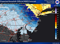
Summary: The updated NWS snowfall map and updated warnings (pink) and advisories (blue) map are below, with the NWS adding Monmouth, Middlesex and Somerset to the warnings, but really only for the northern parts of these counties where 5-6" is expected vs 3-5" for the southern parts (where sleet will replace some of that snow) - so CNJ is right on the knife's edge of snow vs. sleet. Advisories are up for counties S/SW of the Monmouth to Somerset/Warren swath in NJ/PA for 1-3/2-4" snowfall (Hunterdon/Mercer are forecast to get 2-4" snow/sleet) with at least an inch or so of sleet (and maybe a bit of freezing rain in some locations). For areas from Philly and adjacent SNJ SW-ward, the advisories are for <1" of snow but up to 0.1" of freezing rain. Expect snow to start around 4-6 pm with temps in the upper 20s so the snow will accumulate on all surfaces, and the snow (and sleet for some) will hit heavy from then through about 1-2 am with lighter precip the rest of the overnight through maybe 9-10 am, but probably 80% of the precip falls by 2 am. Further NE, all snow is expected for Warren, Sussex, Morris and all of NENJ from Union up to Bergen, as well as for all of NYC/LI and the Hudson Valley (where the most snow is likely, due to more precip). Most other media sources are showing fairly similar forecasts to the NWS (and similar to what I shared last night).
https://www.weather.gov/phi/winter
https://www.americanwx.com/bb/topic/62460-snow-potential-dec-26-27/page/40/
Details: So, I honestly have no idea what's going to happen with this one (well, not nearly as much as I'd like, lol). If one looks at the low end (10% chance) snowfall map from the NWS, one can see the huge bust potential on snowfall amounts, noting that the difference between the expected snowfall and the low end snowfall maps is mostly sleet, so the impacts will still be there even for the "low end" scenario. The high end scenario (10% chance) only has 2-3" more of snow than the expected scenario so the bust potential is a smaller difference; link to the NWS winter weather page is below. And trying to predict how much warm air comes in between the 700 and 850 mbar levels in the atmosphere several thousand feet up to melt the falling snowflakes, which then refreeze in the sub-32F bottom 2000-3000 feet of the atmospheric column into sleet, is really really difficult. Really.
To illustrate this, just for the Edison area, snowfall amounts across about 10 global and mesoscale models show a range of 3-10" of snow with a mean of about 5-6" (which is what the NWS is predicting), but it needs to be noted that for the models showing low amounts of snow, they do forecast at least 1" or so of sleet, which is equivalent (in mass) to 3" of snow (so 2" of snow and 1" of sleet would be equivalent, in mass, to 5" of snow), so the storm is going to be quite impactful whether it's all snow or half snow/half sleet and while sleet isn't nearly as pretty and doesn't cause visibility issues it's just as difficult to drive on as snow and it melts much more slowly and is just as hard to remove/shovel.
It's also worth noting that the 12Z NAM finally caved to the rest of the models: for 2 days it has shown little snow SW of about Wantage (Sussex Co) to NYC (showing mostly sleet), but with the 12Z run it has several inches of snow SW of that line (the 3" line is Long Valley to Perth Amboy). Also, keep in mind that for most of the region temps will be in the upper 20s when precip starts around 4-6 pm, so any snow (or sleet for some) will rapidly accumulate on all surfaces making for hazardous driving conditions, even on treated surfaces, especially through 10-11 pm when the heaviest precip will be falling. And even tomorrow morning, with much lighter snow (any sleet will change back to snow for most by 5 am) temps will be in the upper 20s, so not much melting will occur during the day (highs will be around 32F for most). Be careful out there, but also try to get out in it and have a little fun - maybe make a snow (or sleet) angel.


Attachments
-
 1766757195641.png485.9 KB · Views: 4
Last edited:

the gfs has always consistently been the snowiest model for this storm but the 12z now starting to show chinks in the armor, is it caving to the euro and canadian

the writing on the wall on this one...every model has shifted in the last few days from a sweet spot of northern nj through north central jersey, nyc, and northern nj coast to sweet spot now in extreme NJ into ny state. Cannot deny it.
its really starting to look like a 9 hour window of precip with most of it falling in the 7pm to midnight timeframe where we get our thump of snow with possible heavy amounts in the northern sections and then snizzle kind of precip after.
its really starting to look like a 9 hour window of precip with most of it falling in the 7pm to midnight timeframe where we get our thump of snow with possible heavy amounts in the northern sections and then snizzle kind of precip after.
These updated predicted totals for the Shore are strange. Manasquan getting a coating to 1 inch, while Point Pleasant, South of Manasquan 2-4 inches, and Belmar, slightly north getting 2-4 inches, and Red Bank, 10-12 miles north of Manasquan getting a coating to 1 inch. Maybe the editor messed these up:
Here are predicted inch counts for towns in Monmouth County:
Here are predicted inch counts for towns in Ocean County:
- Allentown: 1 to 3 inches
- Asbury Park: 3 to 6 inches
- Belmar: 2 to 4 inches
- Eatontown: 3 to 6 inches
- Freehold: 3 to 6 inches
- Highlands: 3 to 6 inches
- Keyport: 3 to 6 inches
- Long Branch: 3 to 6 inches
- Manalapan: 3 to 6 inches
- Manasquan: 2 to 4 inches
- Red Bank: 1 to 3 inches
- Shrewsbury: 1 to 3 inches
- Tinton Falls: 3 to 6 inches
- Union Beach: 3 to 6 inches
- Barnegat Light: coating to 1 inch
- Beach Haven: rain only
- Harvey Cedars: coating to 1 inch
- Jackson: 1 to 3 inches
- Lacey: coating to 1 inch
- Lakewood: 2 to 4 inches
- Little Egg Harbor: coating to 1 inch
- Manchester: some ice
- Point Pleasant: 2 to 4 inches
- Seaside Heights: coating to 1 inch
- Ship Bottom: coating to 1 inch
- Toms River: 2 to 4 inches
- Tuckerton: coating to 1 inch

Snow forecast: Predicted town totals for Monmouth, Ocean counties
Check the latest snow forecast for Monmouth and Ocean counties. Accumulating snow is expected to begin around 1 p.m. Friday.www.app.com
predicted inch counts for towns in Monmouth County:
- Allentown: 1 to 3 inches
- Asbury Park: 2 to 4 inches
- Belmar: 2 to 4 inches
- Eatontown: 1 to 3 inches
- Freehold: 2 to 4 inches
- Highlands: 2 to 4 inches
- Keyport: 3 to 6 inches
- Long Branch: 1 to 3 inches
- Manalapan: 1 to 3 inches
- Manasquan: coating to 1 inch
- Red Bank: 1 to 3 inches
- Shrewsbury: 1 to 3 inches
- Tinton Falls: 1 to 3 inches
- Union Beach: 3 to 6 inches
- Barnegat Light: 1 to 3 inches
- Beach Haven: coating to 1 inch
- Harvey Cedars: 2 to 4 inches
- Jackson: coating to 1 inch
- Lacey: 1 to 2 inches
- Lakewood: 1 to 2 inches
- Little Egg Harbor: 1 to 3 inches
- Manchester: 2 to 4 inches
- Point Pleasant: 2 to 4 inches
- Seaside Heights: 1 to 2 inches
- Ship Bottom: 2 to 4 inches
- Toms River: 2 to 4 inches
- Tuckerton: 1 to 3 inches

Snow forecast: Predicted town totals for Monmouth, Ocean counties
Check the latest snow forecast for Monmouth and Ocean counties. Accumulating snow is expected to begin around 3 p.m. Friday.
www.app.com
In all aspects, the Asbury Park Press is an embarrassment.These updated predicted totals for the Shore are strange. Manasquan getting a coating to 1 inch, while Point Pleasant, South of Manasquan 2-4 inches, and Belmar, slightly north getting 2-4 inches, and Red Bank, 10-12 miles north of Manasquan getting a coating to 1 inch. Maybe the editor messed these up:
predicted inch counts for towns in Monmouth County:
predicted inch counts for towns in Ocean County:
- Allentown: 1 to 3 inches
- Asbury Park: 2 to 4 inches
- Belmar: 2 to 4 inches
- Eatontown: 1 to 3 inches
- Freehold: 2 to 4 inches
- Highlands: 2 to 4 inches
- Keyport: 3 to 6 inches
- Long Branch: 1 to 3 inches
- Manalapan: 1 to 3 inches
- Manasquan: coating to 1 inch
- Red Bank: 1 to 3 inches
- Shrewsbury: 1 to 3 inches
- Tinton Falls: 1 to 3 inches
- Union Beach: 3 to 6 inches
- Barnegat Light: 1 to 3 inches
- Beach Haven: coating to 1 inch
- Harvey Cedars: 2 to 4 inches
- Jackson: coating to 1 inch
- Lacey: 1 to 2 inches
- Lakewood: 1 to 2 inches
- Little Egg Harbor: 1 to 3 inches
- Manchester: 2 to 4 inches
- Point Pleasant: 2 to 4 inches
- Seaside Heights: 1 to 2 inches
- Ship Bottom: 2 to 4 inches
- Toms River: 2 to 4 inches
- Tuckerton: 1 to 3 inches
Snow forecast: Predicted town totals for Monmouth, Ocean counties
Check the latest snow forecast for Monmouth and Ocean counties. Accumulating snow is expected to begin around 3 p.m. Friday.www.app.com
I’d say that’s a bit aggressive. But a hugely difficult forecast.Metuchen Borough in with a prediction of 6 inches
id go with lower amounts across most of NJ due to recent trends.
But it’s pretty much time to now cast
I’m usually fond of snow but my neighbor and his family are sunning themselves in Playa del Carmen and I’ll have two sidewalks and long driveways to clear. Not looking forward to it.

For this storm, snow increases from SW to NE, which is not the usual gradient (usually increases SE to NW) due to the orientation of the incoming system moving NW to SE as opposed to a coastal low moving SW to NE. Explains much of those numbers.These updated predicted totals for the Shore are strange. Manasquan getting a coating to 1 inch, while Point Pleasant, South of Manasquan 2-4 inches, and Belmar, slightly north getting 2-4 inches, and Red Bank, 10-12 miles north of Manasquan getting a coating to 1 inch. Maybe the editor messed these up:
predicted inch counts for towns in Monmouth County:
predicted inch counts for towns in Ocean County:
- Allentown: 1 to 3 inches
- Asbury Park: 2 to 4 inches
- Belmar: 2 to 4 inches
- Eatontown: 1 to 3 inches
- Freehold: 2 to 4 inches
- Highlands: 2 to 4 inches
- Keyport: 3 to 6 inches
- Long Branch: 1 to 3 inches
- Manalapan: 1 to 3 inches
- Manasquan: coating to 1 inch
- Red Bank: 1 to 3 inches
- Shrewsbury: 1 to 3 inches
- Tinton Falls: 1 to 3 inches
- Union Beach: 3 to 6 inches
- Barnegat Light: 1 to 3 inches
- Beach Haven: coating to 1 inch
- Harvey Cedars: 2 to 4 inches
- Jackson: coating to 1 inch
- Lacey: 1 to 2 inches
- Lakewood: 1 to 2 inches
- Little Egg Harbor: 1 to 3 inches
- Manchester: 2 to 4 inches
- Point Pleasant: 2 to 4 inches
- Seaside Heights: 1 to 2 inches
- Ship Bottom: 2 to 4 inches
- Toms River: 2 to 4 inches
- Tuckerton: 1 to 3 inches
Snow forecast: Predicted town totals for Monmouth, Ocean counties
Check the latest snow forecast for Monmouth and Ocean counties. Accumulating snow is expected to begin around 3 p.m. Friday.www.app.com
lol, maybe they're using my guesstimate of 6.1" - where do you see that?Metuchen Borough in with a prediction of 6 inches
Phone call and text alerts.lol, maybe they're using my guesstimate of 6.1" - where do you see that?
The heaviest precip axis has shifted NE, no doubt. However, the amount of precip forecast by most models today vs. 48 hours ago for most of CNJ/NNJ/NYC hasn't changed all that much (apart from the Euro, which has definitely decreased precip), so the amount of snow/sleet still looks pretty similar which is why the NWS total precip maps for our area haven't changed much; of course the breakdown of snow vs. sleet SW of a line from about NYC to the Sussex/Warren border will likely remain in question until the storm is well underway. You are correct, though on 75% of the precip falling by 1-2 am, which I've been noting also; although coastal sections might get a late band coming through from coastal enhancement around sunrise.the writing on the wall on this one...every model has shifted in the last few days from a sweet spot of northern nj through north central jersey, nyc, and northern nj coast to sweet spot now in extreme NJ into ny state. Cannot deny it.
its really starting to look like a 9 hour window of precip with most of it falling in the 7pm to midnight timeframe where we get our thump of snow with possible heavy amounts in the northern sections and then snizzle kind of precip after.
I do communicate my weather info (which remains largely NWS info, which they know) to the mayor (who is a good friend) and the Board of Ed Superintendent, who sometimes use it for their communications.Phone call and text alerts.

Jonathan is a also a friend and neighbor. Really good guy and a solid mayor.I do communicate my weather info (which remains largely NWS info, which they know) to the mayor (who is a good friend) and the Board of Ed Superintendent, who sometimes use it for their communications.
Will there be one more NWS update today?For this storm, snow increases from SW to NE, which is not the usual gradient (usually increases SE to NW) due to the orientation of the incoming system moving NW to SE as opposed to a coastal low moving SW to NE. Explains much of those numbers.
Still seeing a disconnect between the text NWS and graphical hourly totals for "Allenwood," about 3 miles west of Manasquan. Text forecast is back up to 2-4 inches from 1-3 inches, while the graphical forecast is showing 3.1" total with a long period of rain. Yeah, splitting hairs here. We land around midnight tomorrow at EWR, and hoping our flight is not delayed and there is minimal snow on our driveway.
So, you're saying I'll get an inch to maybe two in Howell. I am writing this down and holding you to that. Just like the B1G wrestling tickets I have the memory of an Elephant. We're talking decdes until I let this sh*t go.These updated predicted totals for the Shore are strange. Manasquan getting a coating to 1 inch, while Point Pleasant, South of Manasquan 2-4 inches, and Belmar, slightly north getting 2-4 inches, and Red Bank, 10-12 miles north of Manasquan getting a coating to 1 inch. Maybe the editor messed these up:
predicted inch counts for towns in Monmouth County:
predicted inch counts for towns in Ocean County:
- Allentown: 1 to 3 inches
- Asbury Park: 2 to 4 inches
- Belmar: 2 to 4 inches
- Eatontown: 1 to 3 inches
- Freehold: 2 to 4 inches
- Highlands: 2 to 4 inches
- Keyport: 3 to 6 inches
- Long Branch: 1 to 3 inches
- Manalapan: 1 to 3 inches
- Manasquan: coating to 1 inch
- Red Bank: 1 to 3 inches
- Shrewsbury: 1 to 3 inches
- Tinton Falls: 1 to 3 inches
- Union Beach: 3 to 6 inches
- Barnegat Light: 1 to 3 inches
- Beach Haven: coating to 1 inch
- Harvey Cedars: 2 to 4 inches
- Jackson: coating to 1 inch
- Lacey: 1 to 2 inches
- Lakewood: 1 to 2 inches
- Little Egg Harbor: 1 to 3 inches
- Manchester: 2 to 4 inches
- Point Pleasant: 2 to 4 inches
- Seaside Heights: 1 to 2 inches
- Ship Bottom: 2 to 4 inches
- Toms River: 2 to 4 inches
- Tuckerton: 1 to 3 inches
Snow forecast: Predicted town totals for Monmouth, Ocean counties
Check the latest snow forecast for Monmouth and Ocean counties. Accumulating snow is expected to begin around 3 p.m. Friday.www.app.com

Wow, Mt. Holly updated their warnings for Somerset, Middlesex and Monmouth to 4-7" (they'd been saying 3-5" but noted 5-6" likely for northern sections of each county in their morning AFD and they still note the sharp south to north gradient due to sleet). And my hourly graphic snow went up from 5.7" to 6.1" which is exactly my prediction from yesterday, lol. The rest of the advisories and warnings were updated too, which includes Hunterdon/Mercer being upped from 2-4" of snow/sleet to 3-5" and the warnings for all of NENJ (Union to Bergen), NYC, SENY and most of LI were bumped up to 6-9".
URGENT - WINTER WEATHER MESSAGE National Weather Service Mount Holly NJ 125 PM EST Fri Dec 26 2025 Somerset-Middlesex-Western Monmouth- Including the cities of Somerville, New Brunswick, and Freehold 125 PM EST Fri Dec 26 2025 ...WINTER STORM WARNING REMAINS IN EFFECT UNTIL 10 AM EST SATURDAY...
URGENT - WINTER WEATHER MESSAGE National Weather Service Mount Holly NJ 125 PM EST Fri Dec 26 2025 Somerset-Middlesex-Western Monmouth- Including the cities of Somerville, New Brunswick, and Freehold 125 PM EST Fri Dec 26 2025 ...WINTER STORM WARNING REMAINS IN EFFECT UNTIL 10 AM EST SATURDAY...
- WHAT...Heavy mixed precipitation expected. Total snow and sleet accumulations between 4 and 7 inches and ice accumulations around a light glaze.
I'm saying nothing on a forecast- too much uncertainty. I'm sitting in sunny Arizona, trying to decide if I should come back to the cold, snowy hellhole that is NJ.So, you're saying I'll get an inch to maybe two in Howell. I am writing this down and holding you to that. Just like the B1G wrestling tickets I have the memory of an Elephant. We're talking decdes until I let this sh*t go.
You never let us know if you brand new 3-4 year old snowblower worked in the last storm--did it? If so, may I come by and borrow it, because mine crapped the bed during the last storm? Need to replace the auger belt, and I have no desire to tear into it or send it for service until the Spring.
I was ahead of my time with those wrestling tickets that my fire dept buddy welched on buying after I bought them from you. Never been to a wrestling match, and given the state of the program, never will be.
Good luckWow, Mt. Holly updated their warnings for Somerset, Middlesex and Monmouth to 4-7" (they'd been saying 3-5" but noted 5-6" likely for northern sections of each county in their morning AFD and they still note the sharp south to north gradient due to sleet). And my hourly graphic snow went up from 5.7" to 6.1" which is exactly my prediction from yesterday, lol. The rest of the advisories and warnings were updated too, which includes Hunterdon/Mercer being upped from 2-4" of snow/sleet to 3-5" and the warnings for all of NENJ (Union to Bergen), NYC, SENY and most of LI were bumped up to 6-9".
URGENT - WINTER WEATHER MESSAGE National Weather Service Mount Holly NJ 125 PM EST Fri Dec 26 2025 Somerset-Middlesex-Western Monmouth- Including the cities of Somerville, New Brunswick, and Freehold 125 PM EST Fri Dec 26 2025 ...WINTER STORM WARNING REMAINS IN EFFECT UNTIL 10 AM EST SATURDAY...
ADDITIONAL DETAILS...There will be a sharp gradient from south to north across the counties. Highest snow amounts will be in the northern half of the county as sleet mixes in from the south. Rates of up to 1 inch an hour will cause travel impacts Friday night.
- WHAT...Heavy mixed precipitation expected. Total snow and sleet accumulations between 4 and 7 inches and ice accumulations around a light glaze.
2-5 call for appropriate...what model supports more than 5 inches in Somerset?
In fact their probability take is less than 50% for more than 4 inches
I'd rather have just snow then any mixing. It's way easier to shovel then that heavy slop.
I did see Monday is gonna be in the 50's with rain so what ever falls should be gone quick
I did see Monday is gonna be in the 50's with rain so what ever falls should be gone quick
It worked great. You know the usual fumbling around with the controls until I got used to them. 301 cc on a 28" auger is enough power that I can hurl rocks 35 to 40 feet with it. Broke a shear pin within 30 mins. and got it so wedged in, it took me 20 minutes with a punch to hammer it out. It was everything I thought it was going to be. I've now spent another $70 bucks on larger shoes so it won't dig into the stone driveway.I'm saying nothing on a forecast- too much uncertainty. I'm sitting in sunny Arizona, trying to decide if I should come back to the cold, snowy hellhole that is NJ.
You never let us know if you brand new 3-4 year old snowblower worked in the last storm--did it? If so, may I come by and borrow it, because mine crapped the bed during the last storm? Need to replace the auger belt, and I have no desire to tear into it or send it for service until the Spring.
I was ahead of my time with those wrestling tickets that my fire dept buddy welched on buying after I bought them from you. Never been to a wrestling match, and given the state of the program, never will be.
NWS-Philly finally updated their snowfall map and they're clearly not backing down, despite some models showing less at 12Z than they did earlier (but not all - a few show more). We'll see if they're right or not, but I'll admit I'm a bit pessimistic about reach my 6.1" prediction for my house. 4-5" might be a better guess now, but can't change what I predicted - will have to go down with the ship if I'm wrong.Wow, Mt. Holly updated their warnings for Somerset, Middlesex and Monmouth to 4-7" (they'd been saying 3-5" but noted 5-6" likely for northern sections of each county in their morning AFD and they still note the sharp south to north gradient due to sleet). And my hourly graphic snow went up from 5.7" to 6.1" which is exactly my prediction from yesterday, lol. The rest of the advisories and warnings were updated too, which includes Hunterdon/Mercer being upped from 2-4" of snow/sleet to 3-5" and the warnings for all of NENJ (Union to Bergen), NYC, SENY and most of LI were bumped up to 6-9".
URGENT - WINTER WEATHER MESSAGE National Weather Service Mount Holly NJ 125 PM EST Fri Dec 26 2025 Somerset-Middlesex-Western Monmouth- Including the cities of Somerville, New Brunswick, and Freehold 125 PM EST Fri Dec 26 2025 ...WINTER STORM WARNING REMAINS IN EFFECT UNTIL 10 AM EST SATURDAY...
ADDITIONAL DETAILS...There will be a sharp gradient from south to north across the counties. Highest snow amounts will be in the northern half of the county as sleet mixes in from the south. Rates of up to 1 inch an hour will cause travel impacts Friday night.
- WHAT...Heavy mixed precipitation expected. Total snow and sleet accumulations between 4 and 7 inches and ice accumulations around a light glaze.
State of emergency called in NJ. Weather Channel shows 1 to 3 in their discussion in Hillsborough.