Down goes Mount Holly!Mt Holly conducting fire sale on snow amounts in new disco
Down goes Mount Holly!Mt Holly conducting fire sale on snow amounts in new disco
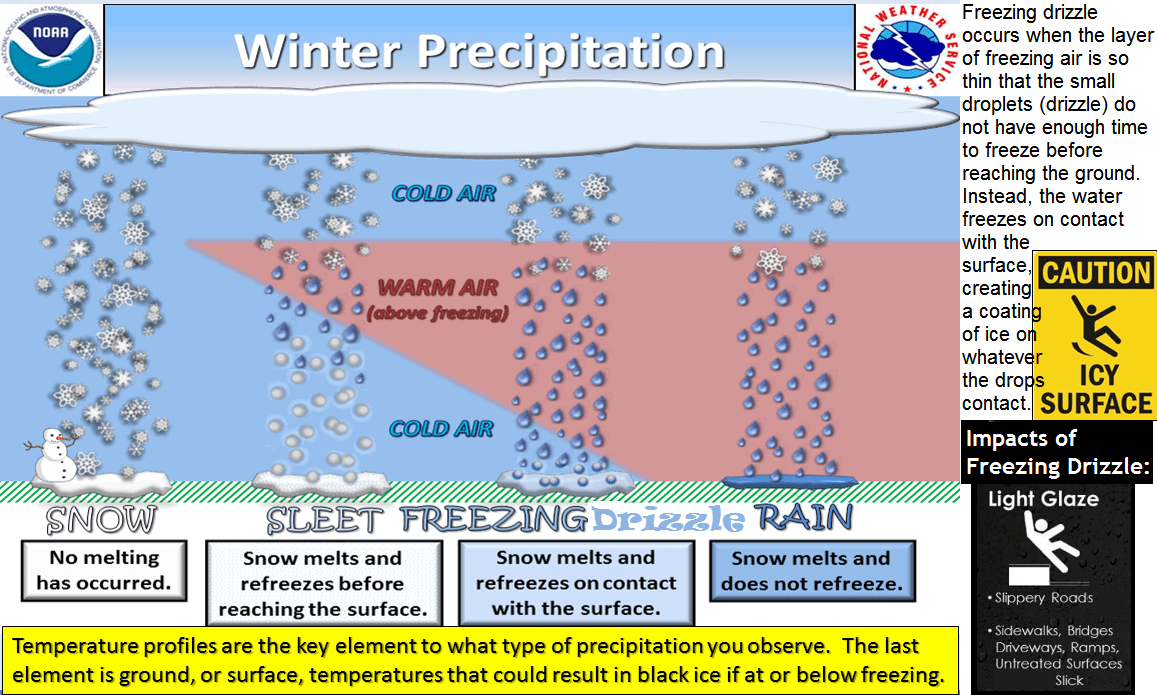
Freezing rain happens when snow melts into rain in a warm air layer aloft, then falls through a shallow, cold layer near the ground, becoming supercooled (below freezing but still liquid) and freezing instantly upon contact with surfaces below 32°F (0°C), creating a clear, dangerous glaze of ice. This requires a specific temperature profile: cold air (snow), then warm (melted snow), then a thin cold layer (supercooling).I've got straight up ice pellets coming down in Howell. It's 28 degrees here, (have outdoor thermomotor), so one of you weather weenies is going to have to explain the meteorological mumbo jumbo for me into layman's terms on this occurrence.
Same story in East Brunswick.Straight icing in Sayreville. Ugh.

I've got straight up ice pellets coming down in Howell. It's 28 degrees here, (have outdoor thermomotor), so one of you weather weenies is going to have to explain the meteorological mumbo jumbo for me into layman's terms on this occurrence.
I mean ... that's funny.Back to snowing. Hopefully stays that way.
Edit: Now back to ice. This storm is bipolar.
He has ice pellets, aka sleet, not freezing rain, but at least the graphic is good, as it does explain sleet.Freezing rain happens when snow melts into rain in a warm air layer aloft, then falls through a shallow, cold layer near the ground, becoming supercooled (below freezing but still liquid) and freezing instantly upon contact with surfaces below 32°F (0°C), creating a clear, dangerous glaze of ice. This requires a specific temperature profile: cold air (snow), then warm (melted snow), then a thin cold layer (supercooling).
The mt holly map did another huge slash for my areaAs of 8:00 pm, we've had 1/3" of pure sleet that is hard and crusty and slippery as hell and should be the equivalent of about 1" of snow, mass-wise. That sleet was mostly over by about 6:30 pm and since then we've had more of a mix of snow and sleet, which is dense, but not crusty, on top of that sleet; that layer is about 3/8" right now, so officially 0.7" snow/sleet so far and we have probably 50/50 snow/sleet falling now. I sure hope we get some of that pure white snow ("twice as sweet as sugar, twice as bitter as salt" - name that tune w/o Google). My updated point/click says 2-4" and my hourly graphic says 3.0" of "snow" to come. Crossing fingers. It really is icy out there.
Radar looks awful but short term model wants to refire by midnight...its iffyUp here in western Bergen and radar looks like it's almost done...? Or am I being too simplistic?
That's what I'm seeing in eastern Bergen....a coating and the radar indicating it will be done by 9 p.m.Up here in western Bergen and radar looks like it's almost done...? Or am I being too simplistic?
I really would love to be a meteorologist they have to be wrong 80% of the time what a great job!!As of 8:00 pm, we've had 1/3" of pure sleet that is hard and crusty and slippery as hell and should be the equivalent of about 1" of snow, mass-wise. That sleet was mostly over by about 6:30 pm and since then we've had more of a mix of snow and sleet, which is dense, but not crusty, on top of that sleet; that layer is about 3/8" right now, so officially 0.7" snow/sleet so far and we have probably 50/50 snow/sleet falling now. I sure hope we get some of that pure white snow ("twice as sweet as sugar, twice as bitter as salt" - name that tune w/o Google). My updated point/click says 2-4" and my hourly graphic says 3.0" of "snow" to come. Crossing fingers. It really is icy out there.
Yup and despite yearly busts it all gets memoryholed with no accountabilityI really would love to be a meteorologist they have to be wrong 80% of the time what a great job!!
As of 8:00 pm, we've had 1/3" of pure sleet that is hard and crusty and slippery as hell and should be the equivalent of about 1" of snow, mass-wise. That sleet was mostly over by about 6:30 pm and since then we've had more of a mix of snow and sleet, which is dense, but not crusty, on top of that sleet; that layer is about 3/8" right now, so officially 0.7" snow/sleet so far and we have probably 50/50 snow/sleet falling now. I sure hope we get some of that pure white snow ("twice as sweet as sugar, twice as bitter as salt" - name that tune w/o Google). My updated point/click says 2-4" and my hourly graphic says 3.0" of "snow" to come. Crossing fingers. It really is icy out there.

What does this even mean? Do you want to have them blindfolded and shot? Public flogging? It's a friggin' hard science to get right and there will be busts from time to time. There's no conspiracy here, especially since forecasts are way better today than they were even 25 years ago. I actually kind of like that it's so chaotic and complex that we still get busts occasionally (in both directions - see Feb 24 where we got 11" vs. 3" expected), as that always adds some drama to the enterprise.Yup and despite yearly busts it all gets memoryholed with no accountability
You just scored some Rock! Freeze! Rock! Freeze!
More sadness for snow lovers as the NWS cut back further...Ouch. Looks like the NAM was right all along. Big fail for numerical modeling today, assuming this verifies. Warnings dropped for Warren, Somerset, Middlesex and Monmouth and snowfall amounts cut back there and SW of there, by quite a bit. Concern now is whether this could mean a lot more freezing rain, which would suck. Updated snow and ice maps below.
Area Forecast Discussion
National Weather Service Mount Holly NJ
621 PM EST Fri Dec 26 2025
.NEAR TERM /THROUGH SATURDAY/...
620 PM update...
Well, that changed quickly. The models that were surging in the
warm air aloft (NAM in particular) seem to have mostly had a
handle on things, at least across our CWA, with most areas
already changed to freezing rain and sleet. Have made a
significant cut to snowfall totals, which necessitated dropping
the warnings for Monroe, Warren, Middlesex and Monmouth
counties. That having been said, we are now starting to get
anxious about ice accumulation, since several more hours of
freezing rain may put some areas in the game for ice storm
warning criteria (1/4 inch). Made some upward adjustments in the
ice forecast and will watch obs closely over the next few
hours.
View attachment 1095318
View attachment 1095321

Should we change the title again to "Significant Bust On Friday Night"?
Masco clinging on.Yup and despite yearly busts it all gets memoryholed with no accountability
Public flogging would be nice. Can't be so bad at your job without some criticism. Remember, every time they screw the pooch, the more likely people will ignore the next warning (even if the next event is legit).What does this even mean? Do you want to have them blindfolded and shot? Public flogging? It's a friggin' hard science to get right and there will be busts from time to time. There's no conspiracy here, especially since forecasts are way better today than they were even 25 years ago. I actually kind of like that it's so chaotic and complex that we still get busts occasionally (in both directions - see Feb 24 where we got 11" vs. 3" expected), as that always adds some drama to the enterprise.
Such an epic bust that it's not worth trolling. Just sad.bust city


