OT: Tracking Winter Storm Fern 1/25-26
- Thread starter bac2therac
- Start date
You are using an out of date browser. It may not display this or other websites correctly.
You should upgrade or use an alternative browser.
You should upgrade or use an alternative browser.


early calls are starting
I think that’s a little conservative but I guess better to start low and go higher
Had Dan Zarrow posted a recent update? Was he at 6-8 in CNJ?do they even exist anymore
I think he is waiting until tonight,,,,6 plus for everyone, i expect him to be 6-12 for a wide swathHad Dan Zarrow posted a recent update? Was he at 6-8 in CNJ?
for the coast it looks conservative as G might feel that mixing or changeover takes place.....certainly there is support but for elsewhere its in line..some can quibble and say 8-12..for central jersey into suburbs of nyc instead of 6-10 but its a first call, I think 6-12 would satisfy all and maybe put the coast 4-8I think that’s a little conservative but I guess better to start low and go higher
early calls are starting
I'd be pretty bummed in the Red Bank/Long Branch area if we only got 4-6" after all of the early hype talking about a "memorable storm". 4-6" isn't any different than any other run of the mill winter snow storm.
well that 4-6 inches would have sleet and ice too on top of that and you still may get 8-10 inches which is hardly a disappointment
i think the hype 7-10 days out is always unwarranted, this is still close to giving everyone a foot but modelling 7 days outs is never going to be accurate and even 3 days out we still havent pinned the details out
i think the hype 7-10 days out is always unwarranted, this is still close to giving everyone a foot but modelling 7 days outs is never going to be accurate and even 3 days out we still havent pinned the details out
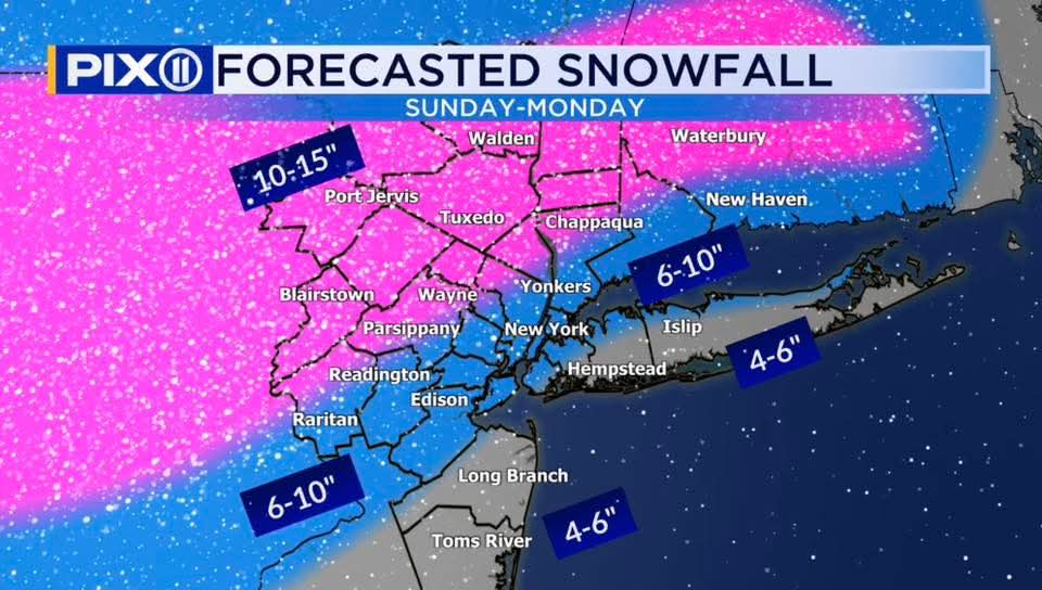
Shoujd be colder than 10:1 ratio - here is the kuchera map which factors in ratioEuro Monday morning snowfall 6-10 inches


We have no ideas ratios yet..its best to go with 10-1 until we figure out how much of the warm nose infiltrates. Near the changeover mixing will cancel out the early high ratiosShoujd be colder than 10:1 ratio - here is the kuchera map which factors in ratio
Last edited:
I’m ready for whatever comes. My snowblower will be back from the shop in two weeks. 

Had an issue with my snowblower that we leave at a customers house. He is a corner lot with sidewalks that have to get done. Cord pulled out so we use the electric start on it. Just plug in outside outlet and we are good to go.
We have no ideas ratios yet..its best to go with 10-1 until we figure out how much of the warm. Near the changeover mixing will cancel out the early high ratios
agree about not knowing what ratios it will be…Which is why I think kuchera should be what we’re using since it factors in temperature to estimate the likely ratio.
But all good - just goes to show how unpredictable this storm will be and range of outcomes possible
Gotta admit to being a bit jealous Here in Bend (OR) we're on our sixth day of freezing fog, which actually deposited a very thin layer of light snow/frost that could be shoveled. Ski areas are one the verge of closing. Guess I should enjoy it but I cannot. What supplies have you stocked up on for the big storm?
There are only 3 things on everyone's list.Gotta admit to being a bit jealous Here in Bend (OR) we're on our sixth day of freezing fog, which actually deposited a very thin layer of light snow/frost that could be shoveled. Ski areas are one the verge of closing. Guess I should enjoy it but I cannot. What supplies have you stocked up on for the big storm?
what do you mean when you say "euro at 7PM"?
that’s what the European model predicts the weather will be like at 7pm Sunday.
Pink is mixed precipitation and it’s almost in North NJ.


Mt holly is going to stick with NBM til they fall of a cliff
and their amounts do not even line up with Upton
EDIT the Upton Map goes until 7pm sunday so not complete but at that time the mixing issues are already happening according to most models
they definitely are hugging the gfs
and their amounts do not even line up with Upton
EDIT the Upton Map goes until 7pm sunday so not complete but at that time the mixing issues are already happening according to most models
they definitely are hugging the gfs
Last edited:

Mt holly is going to stick with NBM til they fall of a cliff
and their amounts do not even line up with Upton
EDIT the Upton Map goes until 7pm sunday so not complete but at that time the mixing issues are already happening according to most models
they definitely are hugging the gfs
they also love the Blend of models which continues to increase totals.
thats the same thing..nbm which i dont see how its actually increasing totals given the modellingthey also love the Blend of models which continues to increase totals.
There’s models in the blend I’ve never even heard of and aren’t shared - so I’d assume those are showing more aggressive totals as wellthats the same thing..nbm which i dont see how its actually increasing totals given the modelling
noThere’s models in the blend I’ve never even heard of and aren’t shared - so I’d assume those are showing more aggressive totals as well
all these are available...
What goes into the NBM (Inputs)?
Global Models
- ECMWF (Euro)
- GFS
- CMC (GGEM)
- UKMET
- ICON (limited elements)
Ensembles
- EPS
- GEFS
- GEPS
- HREF (short range)
Regional / Mesoscale
- HRRR
- NAM / NAM-Nest
- RAP
- RGEM
Observations & Post-Processing
- Surface observations
- Climatology
- MOS-style bias correction
- Downscaling to fine grids (~2.5 km)
no
all these are available...
What goes into the NBM (Inputs)?
Global Models
- ECMWF (Euro)
- GFS
- CMC (GGEM)
- UKMET
- ICON (limited elements)
Ensembles
- EPS
- GEFS
- GEPS
- HREF (short range)
Regional / Mesoscale
- HRRR
- NAM / NAM-Nest
- RAP
- RGEM
Observations & Post-Processing
- Surface observations
- Climatology
- MOS-style bias correction
- Downscaling to fine grids (~2.5 km)
NBM Model Inputs - MDL - Virtual Lab
 vlab.noaa.gov
There are many more than you listed. And some you listed (UKIE) aren’t used.
It was taken from a respected poster on the americanwx board soNBM Model Inputs - MDL - Virtual Lab
There are many more than you listed. And some you listed (UKIE) aren’t used.
It was taken from a respected poster on the americanwx board so
all good but my list is taken directly from the agency that uses the model.
the model seems to get new inputs often so I’d assume that poster hasn’t seen the updated list
If that happens, you win an all expenses sleigh ride up the Parkway to Metuchen to party with the Snow Miser.now that i've canceled my plans i hope we get 2 feet
18z nam was colder... storms comes in earlier..the mix gets to central jersey eventually but at taile end after we thump. These amounts are a decent bounce up from their earlier run. Remember the Nam is still a bit out of its range at this time. It does look like the warming trend on models has at least stopped or is slowing retreating
10-1 ratios, would be slightly higher depending on ratio. 6-12 and less in southern coastal nj

10-1 ratios, would be slightly higher depending on ratio. 6-12 and less in southern coastal nj
At 3 p.m., the NWS in Mount Holly issued a new briefing. They are saying that "widespread total snow amounts ranging from 8-18 inches [are] likely." The lower amounts will be "farther south and closer to the coast, where more wintry mix is likely." The forecast otherwise is for 12-18 inches. "A light glaze to 0.10” of ice is possible,
especially near and southeast of I-95." There is a cold weather advisory for Friday night into Saturday morning, with "dangerously cold wind chills between -10° and 0°" and wind chills as low as -20° in the southern Poconos. In addition, "a prolonged period of well below normal temperatures is expected to continue through next week, with
wind chills in the single digits to below zero at night each night."
https://www.weather.gov/media/phi/current_briefing.pdf

just saw Lees map...much of NJ north of 95 is 6-12...its northwest NJ and morris etc 12 plus also says mixing will cut totals toward monmouth, ocean and coast to south jersey
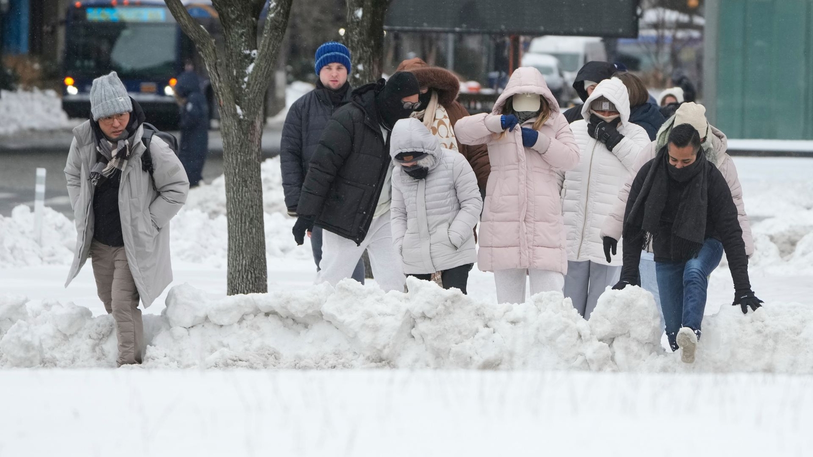
Winter storm pulls away after dumping heavy snow; frigid air won't budge | Live updates
The winter storm of January 2026 that once covered 2,000 miles across the nation has pulled away, leaving New York City and the Tri-State area to dig out from the biggest snowfall in years.
 abc7ny.com

Eyewitness News Live Streaming Video
Watch live streaming video on abc7ny.com and stay up-to-date with the latest Eyewitness News broadcasts as well as live breaking news whenever it happens.
abc7ny.com