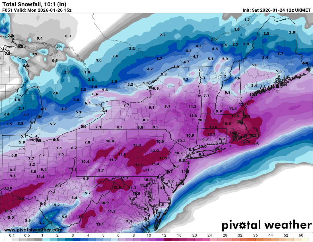
It's Saturday morning and the Accuweather website still has not budged from their prediction of 4-8 inches for Bloomfield ( and NYC)
OT: Tracking Winter Storm Fern 1/25-26
- Thread starter bac2therac
- Start date
You are using an out of date browser. It may not display this or other websites correctly.
You should upgrade or use an alternative browser.
You should upgrade or use an alternative browser.

What difference does it make what anyone wants? Whatever is going to happen is going to happen regardlessThis! There are people who HAVE to get out and get to work…ie health care workers among others. It’s not fun.
The weather thread is always funny because posters project whatever is happening near them is happening all over the state. I mean the difference live north of 78 vs South could mean few inches of snow.
2nd call
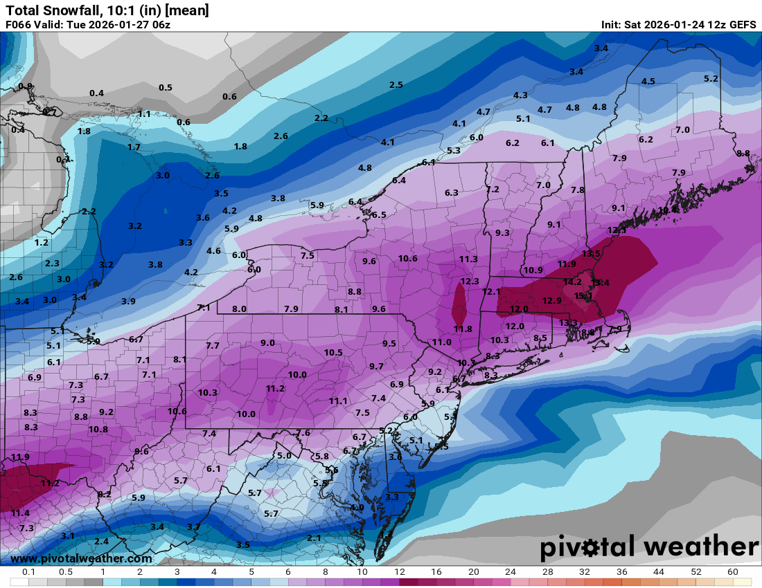
I still think 7-11 is a good call for Union Somerset Mercer Burlington Middlesex. Chances for more north of 78.
10-15 northern nj north of Newark nw counties
6-9 Monmouth/Ocean
3-6 southern Atlantic
Hillsborough Deli: 8
NYC: 8
Newark: 9
Philly: 8
Still could tweak this before final call tonight
I still think 7-11 is a good call for Union Somerset Mercer Burlington Middlesex. Chances for more north of 78.
10-15 northern nj north of Newark nw counties
6-9 Monmouth/Ocean
3-6 southern Atlantic
Hillsborough Deli: 8
NYC: 8
Newark: 9
Philly: 8
Still could tweak this before final call tonight
Maybe as much as foot differenceThe weather thread is always funny because posters project whatever is happening near them is happening all over the state. I mean the difference live north of 78 vs South could mean few inches of snow.
It can happen. Yet its true its on the low side especially for Bloomfield. Everyone is getting the initial thump of snow. The intensity could bring 1-2 inches an hour. How long that lasts before mixing or if we get that intensity can cause wild swings. There are models differences. We will get some more short term modelling today that could give us better confidenceIt's Saturday morning and the Accuweather website still has not budged from their prediction of 4-8 inches for Bloomfield ( and NYC)
The Euro used to be king but has lost its luster. The AI versions of GFS and Euro have been doing well of late. The NAM which is being retired scores high marks on fleshing out warm air aloft like in this storm. They all seem to have their strengths and minuses but none are perfect. See last week where on Friday only the GFS had snow for last Sundays stormWith all these models being not really in line with each other what is considered the overall best model for winter weather?
News 12
Looks like he upped their amounts across CJ

the NAM was really bad for snow lovers....quicker changeover to sleet and totals cut waaaaaaaaaaay back
start time 3-5 AM
thump for 6 hours
mixing entering central jersey by 1pm
sleet goes all the way up to NJ/NY border
verbatim its only 4-6 inches
6-9 hours of mix that could give 1-2 inches of sleet
start time 3-5 AM
thump for 6 hours
mixing entering central jersey by 1pm
sleet goes all the way up to NJ/NY border
verbatim its only 4-6 inches
6-9 hours of mix that could give 1-2 inches of sleet
People look at AccuWeather still?It's Saturday morning and the Accuweather website still has not budged from their prediction of 4-8 inches for Bloomfield ( and NYC)
the RRFS model which is replacing the NAM
snow arriving 3-4 AM
thump for 6-8 hours
has sleet entering central jersey by 2pm
sleet goes all the way up to NJ/NY border
verbatim is 4-8 inches kuchera
snow arriving 3-4 AM
thump for 6-8 hours
has sleet entering central jersey by 2pm
sleet goes all the way up to NJ/NY border
verbatim is 4-8 inches kuchera
lol taken from the weenie board
The NAM is the Aaron Rodgers of models
Clearly ready for the exit
Was always flawed but racked up some big wins in its career
Problematic in ways that distract from its strengths (but fans like it for being "contrarian")
People vigorously rooting for it to lose
Still capable of some key plays that make it impossible to write off
Hillsborough Deli: 8.2nd call
I still think 7-11 is a good call for Union Somerset Mercer Burlington Middlesex. Chances for more north of 78.
10-15 northern nj north of Newark nw counties
6-9 Monmouth/Ocean
3-6 southern Atlantic
Hillsborough Deli: 8
NYC: 8
Newark: 9
Philly: 8
Still could tweak this before final call tonight
That's the minimum, as I remember it.
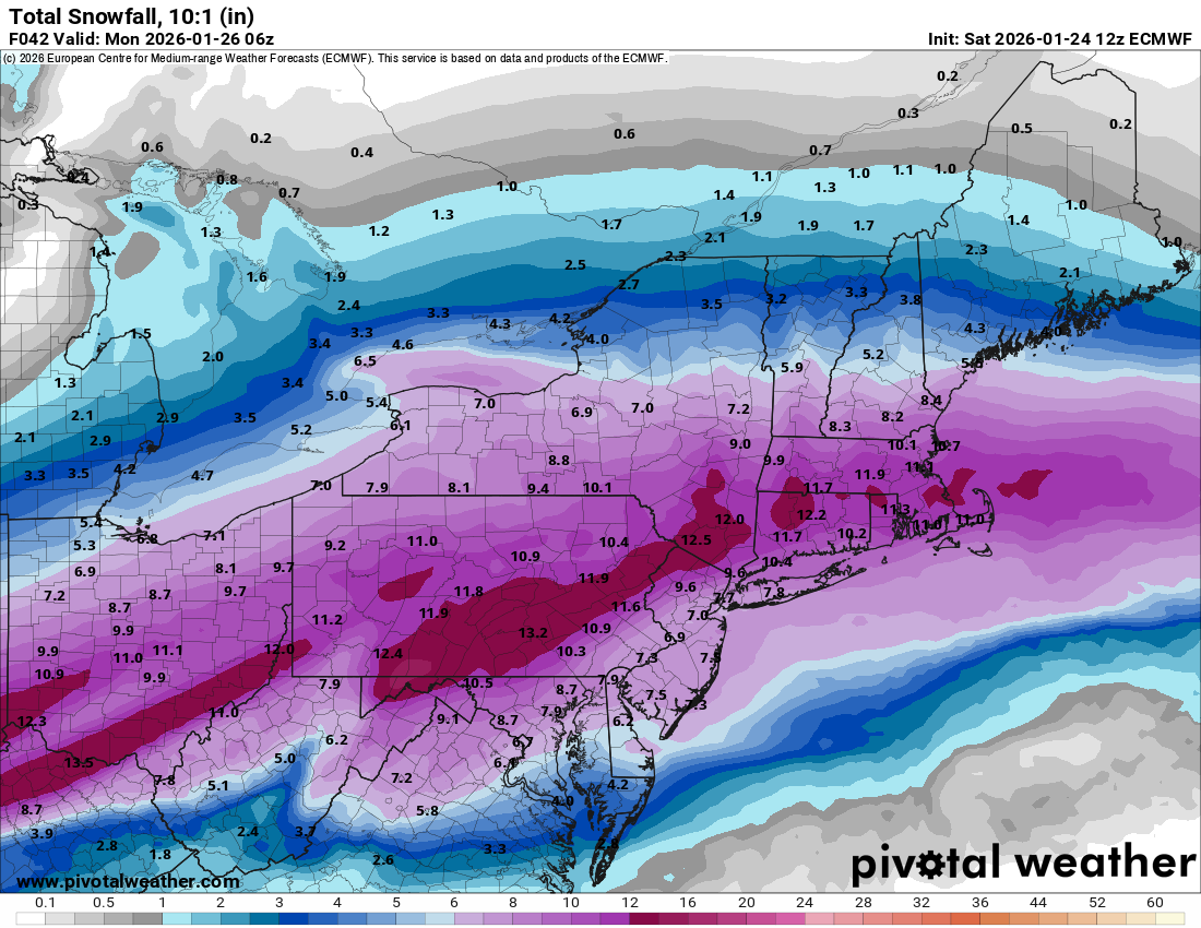
GFS snow starting by 3am
thump for 6-8 hours
sleet entering central jersey by 3-4 pm
sleet all the way up to NJ/NY border by 7pm
verbatim 4-8 inches central jersey and 8-12 north jersey , 3-6 south jersey

thump for 6-8 hours
sleet entering central jersey by 3-4 pm
sleet all the way up to NJ/NY border by 7pm
verbatim 4-8 inches central jersey and 8-12 north jersey , 3-6 south jersey
Just keep the freezing rain away please.GFS snow starting by 3am
thump for 6-8 hours
sleet entering central jersey by 3-4 pm
sleet all the way up to NJ/NY border by 7pm
verbatim 4-8 inches central jersey and 8-12 north jersey , 3-6 south jersey
the HRRR is a very short term model that runs every 18 hours except every 6 hours does a 48 hour run the last of which was the 12z and that is a bit out of its range currently. It usually is a bit boisterous on snow totals so its no surprise its the outlier snowiest model right now in recent runs showing 8-12 from south jersey to trenton and 12-16 north of that. We shall watch these runs all day to see if it cuts back
not a strong signal for that at least away from the coastJust keep the freezing rain away please.
I’ll take the snow over the sleet and rain that’ll make things heavier as far as branches and power lines.Just keep the freezing rain away please.
'The NWS's 5 a.m. briefing continues to back off on snow amounts.The 12-18 inch area in New Jersey has shrunk; it's now confined to (roughly) Morristown north. The 8-12 inch area covers most of the rest of New Jersey, but it includes only the portions of South Jersey in the Philly metro area as well as the areas in South Jersey right by the Delaware. The rest of South Jersey (including the shore south of about Tom's River) is now forecast to get 6-8 inches. At this point, there's roughly a 50-50 chance of 8 or more inches of snow, a one-in five chance of 12 or more inches of snow, in Philadelphia.
The chances of ice continue to be high according to the NWS. To quote: "There remains a threat for notable ice accumulations ranging from 0.1” to 0.3" across the I-95 corridor, southern New Jersey, Eastern Shore of Maryland, and central/northern Delaware. The combination of heavy snofollowed by sleet/freezing rain and breezy northeast winds gusting 20-30 mph could result in some isolatedm instances of downed trees and power lines, and power outages." The prime area for ice accumulations takes in Gloucester county south along the Delaware.
The NWS continues to forecast bitter cold for the days after the storm.
IMHO, snow-haters should not like this forecast; ice is more dangerous and disruptive than snow.
https://www.weather.gov/media/phi/current_briefing.pdf
That 8-12 for Toms RIver is a fireable offense.'The NWS's 5 a.m. briefing continues to back off on snow amounts.The 12-18 inch area in New Jersey has shrunk; it's now confined to (roughly) Morristown north. The 8-12 inch area covers most of the rest of New Jersey, but it includes only the portions of South Jersey in the Philly metro area as well as the areas in South Jersey right by the Delaware. The rest of South Jersey (including the shore south of about Tom's River) is now forecast to get 6-8 inches. At this point, there's roughly a 50-50 chance of 8 or more inches of snow, a one-in five chance of 12 or more inches of snow, in Philadelphia.
The chances of ice continue to be high according to the NWS. To quote: "There remains a threat for notable ice accumulations ranging from 0.1” to 0.3" across the I-95 corridor, southern New Jersey, Eastern Shore of Maryland, and central/northern Delaware. The combination of heavy snofollowed by sleet/freezing rain and breezy northeast winds gusting 20-30 mph could result in some isolatedm instances of downed trees and power lines, and power outages." The prime area for ice accumulations takes in Gloucester county south along the Delaware.
The NWS continues to forecast bitter cold for the days after the storm.
IMHO, snow-haters should not like this forecast; ice is more dangerous and disruptive than snow.
https://www.weather.gov/media/phi/current_briefing.pdf
Ukie is now the coldest and snowiest model
8-11 inches statewide and sleet comes in very late
8-11 inches statewide and sleet comes in very late
Last edited:
we shall see when the dust settles if it is, but its a very aggressive forecastThat 8-12 for Toms RIver is a fireable offense.
not that I think they will be accountable either way. Numbers of course will defend them as if they are his relatives
I think he favors the lower totals in central NJ and along the shore.we shall see when the dust settles if it is, but its a very aggressive forecast
not that I think they will be accountable either way. Numbers of course will defend them as if they are his relatives
Seems that reading the couple of amateur weenies I follow (Mostwill and Tomer), nobody can accurately make a call on the dry slot and what you called warm nose (warm air advection).
My IPhone apple weather app says 17-20” for Philly lol. Where do they get their forecast?
thats true...still uncertainty and not sure any modelling will figure that outI think he favors the lower totals in central NJ and along the shore.
Seems that reading the couple of amateur weenies I follow (Mostwill and Tomer), nobody can accurately make a call on the dry slot and what you called warm nose (warm air advection).
I turned my weather app and alerts off on my Google PixelMy IPhone apple weather app says 17-20” for Philly lol. Where do they get their forecast?
yeah once you flip you pretty much stay that way...so you will get sleet accumulations which could be an inch or a bit aboveBac
Monmouth beach. I’m expecting about 6. Once the mixing starts, do we think that’s it for accumulation? I know it’s supposed to get bitter cold but no switch back ?
FWIW, the forecast for my zip code in Cherry Hill anticipates a change back to snow on Monday morning -- but only less than half an inch of additional accumulation. Previously, this change back was supposed to happen about 4 a.m.yeah once you flip you pretty much stay that way...so you will get sleet accumulations which could be an inch or a bit above
Yeah any snizzle after midnight and monday morning will be total nuisance type stuffFWIW, the forecast for my zip code in Cherry Hill anticipates a change back to snow on Monday morning -- but only less than half an inch of additional accumulation. Previously, this change back was supposed to happen about 4 a.m.
Far cry from what the weenies were saying for the past week.everyone should sign up for euro 6-8 central jersey
18z NAM held serve..still 4-6 inches. Remains least snowiest and warmest model