A more detailed post....
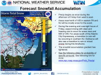
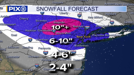
Update: NWS has backed off a bit on snowfall amounts for most folks SW of about a Mt. Pocono to Long Branch line, due to sleet intrusion reducing snow accumulations (sleet is ~3x as dense as snow for the same mass), combined with more precip/snow falling NE of that line, and where NE of that line all snow is expected. I also included 3 other media source snowmaps: TWC, which is similar to the NWS, Mike Masco (Ch 11), who is very bullish on snow, and Lee Goldberg, who is between those two extremes.
Obviously, things can still change in either direction (more snow/less sleet or less snow/more sleet; plain rain is unlikely except for SENJ), since we're ~24 hours from the start of the storm late Friday afternoon with the heaviest snow/sleet falling from about 4-5 pm through 1-2 am. But even though "snow" forecasts have decreased, even areas that might get 2" of snow and 1" of sleet (3" depth) would actually be getting 5" worth of snow as frozen precip, since 1" of sleet is equivalent to 3" of snow, so those areas will still be impacted significantly wrt/roads and removal. One note: while models have trended sleetier and less snowy the past 12-18 hours, the models just coming out now are reversing that trend a bit, leading to more snow/less sleet for areas SW of that Mt. Pocono to Long Branch line; if that continues, forecasts may be bumped back up again.
So only Monroe (PA), Morris, Warren, Sussex and NENJ from Union up to Bergen are under warnings for about 4-8" of snow, while the next tier of counties bordering the warned counties is under advisories for about 3-5" snow/sleet, i.e., Monmouth, Middlesex, Mercer, Somerset, Hunterdon, and Carbon/Lehigh in PA with the next tier of counties to the SW in PA or S in NJ (from Bucks to Burlington to Ocean and SW/S of there through most of SEPA/SNJ) are under advisories for or 1-3" snow/sleet.
The county map shows warnings in pink and advisories in blue. One interesting point is that some media sources have also backed off a bit on snow due mostly to getting more sleet for some areas, while others are still very bullish on 6-10" of snow for most of NEPA/CNJ/NNJ/NYC. Lastly, time for my usual guess: I'll go with 6.1" vs. my NWS point and click of 5.7" (and our advisory of only 3-5").
https://www.weather.gov/phi
https://www.americanwx.com/.../62460-snow.../page/31/...
View attachment 1093924
View attachment 1093918
View attachment 1093919
View attachment 1093921
View attachment 1093922


.thumb.png.d3a3793a6c318a535447bf3e246a6b52.png)